Buffalo Bumble
-
Posts
1,613 -
Joined
-
Last visited
Content Type
Profiles
Blogs
Forums
American Weather
Media Demo
Store
Gallery
Everything posted by Buffalo Bumble
-
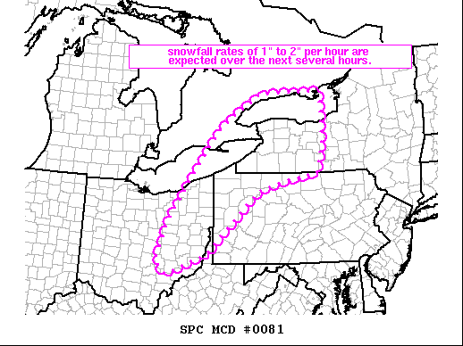
 Has to be 4”/hr here right now. As others have said just massive dendrites in this band.
 -
Heaviest part of the band moving into my area now. Some huge flakes embedded in what’s probably 3”/hour here. I know that’s a warning sign for sleet, cool to watch those flakes pour down though.
-
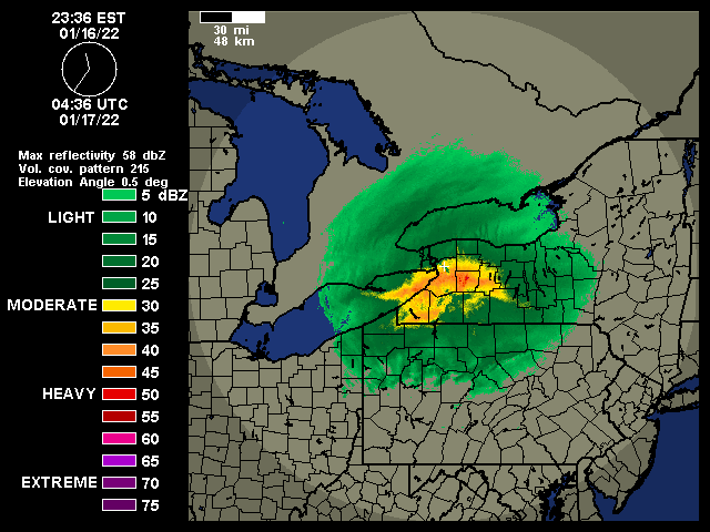
I was a bit worried about downsloping causing this band to dissipate before making it to BUF but here it is…

-
Not the best in the dark but some of the live feeds from Angola to Lackawanna are worth a look at what’s going on in that band right now: https://www.thruway.ny.gov/travelers/map/text/twytextcameras.cgi?region=BUI90W
-
These radars! Like a giant wave of snow rolling north across the southern tier from Bing to Hamburg.
-
Intensity picked up here, probably not quite 1”/ hr rate.
-
Wow! You really don’t often see a band that strong moving in that direction in far WNY. Looks like something coming in at Boston from the ocean.
-
Yep, was just about to post about those incoming “yellows”. Gonna go scout it out as they move in momentarily.
-
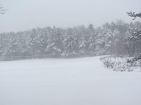
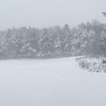
First flakes flying here!
-
?? Current conditions at Pittsburgh - Allegheny County Airport (KAGC) Lat: 40.36°NLon: 79.92°WElev: 1237ft. Light Snow Fog/Mist 22°F -6°C Humidity 92% Wind Speed E 7 mph Barometer 29.74 in (1009.4 mb) Dewpoint 20°F (-7°C) Visibility 1.75 mi Wind Chill 13°F (-11°C) Last update 16 Jan 5:53 pm EST
-
35 deg at BUF currently, forecast high I think was 29. Warm spot in upstate currently, some downslope warming on light southeast wind? Hopefully not a harbinger of “overachieving warmth” to come here in WNY.
-
Looks like she’s finally rounding the bend and starting the journey north. Nice to see a bonafide storm moving our way after days and days of tracking!
-
Another Bills TD! That one was for Tombo.
-
I vaguely remember a big storm around that time, 12”+ in early April in early/mid 2000’s. Track might have been similar too with big negative tilter. Recall being amazed and admittedly annoyed that much snow fell in early April.
-
Wrong forum there Tombo
-
BUF dropping 18-24” for a synoptic storm in WNY. Just wow.
-
Off topic, but are you getting slammed with snow/wind today? Looks like a monster storm ongoing in Newfoundland...
-
Good call! Like Dave said, you can shoot east easily if the heaviest stuff sets up closer to Rochester. Not sure how familiar you are with the area…Besides the obvious attraction at Niagara Falls, Lewiston is a great spot to visit just 10 minutes or so away. Quaint village with coffee house/brewery and a place called Artpark with trails along the Niagara River gorge. If you want room to spread out and walk around or get a snowstorm experience along the shore of Lake Ontario, head to Wilson Tuscorara State Park, 15-20 minutes from NF. If you get there while it’s clear on Sunday you can see the Toronto skyline (usually) across the lake. Fantastic brewery in Wilson too. Happy chasing!!
-
If someone who knows the models better than me can please post something immediately about the NAM being terrible past 24 hours I would really appreciate it.
-
Clearly the Canadians hacked the weather models tonight. It’s the only logical reason for what we’re seeing. Well done Canada.
-
Very cool! We've had snow here all afternoon, mood flakes to start but nice squall ongoing for the last 30 minutes or so. Nice whitening of everything at least as the frigid air moves in.
-
Ok, I was a bit heavy there on the hyperbole. Should have said I'm skeptical of models showing WNY in the bullseye. BUF has a great write-up this morning. Have to check those dates to see how the snow was distributed across upstate. The deterministic runs continue to show a low track that is farther west than climatology. East coast systems typically track along the coast and close to the coastal front, but in THIS case the strong synoptic scale dynamics may overcome that trend and force the low track farther west and well inland across the Mid Atlantic and PA. One big reason for this can be blamed on a large sfc high that will precede the storm...with the high moving off the New England coast and blocking a more typical storm track up the coast. Nor`easters usually run up the coast ahead of the Canadian high...but the timing is such that the sfc high will force the storm system inland and up the coastal plain. Storms of this nature have a history of generating widespread snow throughout all of western and north central New York. Similar sfc patterns occurred with the following storms: 2/13/93, 12/29/97, 1/12/96, 2/23/98, 12/11/92 and 2/12/85.
-
From BUF: The upper level system that will force this system was still over the Pacific Ocean for the 00Z guidance suite, but will move onshore today in the Pacific Northwest and will be better sampled by the radiosonde network and aircraft soundings from this point forward, which should continue to promote converging model solutions and increasing forecast confidence over the next day or two.