

roardog
-
Posts
1,631 -
Joined
-
Last visited
Content Type
Profiles
Blogs
Forums
American Weather
Media Demo
Store
Gallery
Posts posted by roardog
-
-
16 minutes ago, snowman19 said:
All indications are that the SPV is going to strengthen in November right now
Doesn’t it pretty much always strengthen in November as we head into Winter?
-
32 minutes ago, GaWx said:
Thanks Charlie,
This tells me that they still don’t know why there was a sudden spike in the first half of 2023. Just a lot of speculation.
It just seems crazy to me that a volcano can throw as much water vapor into the atmosphere as this one did and it’s pretty much shrugged off as nothing to see here.
-
 1
1
-
-
5 hours ago, WestMichigan said:
Starting with April every month has been below normal in precipitation at GRR including this month so far. The deficit starting with April is not as bad as some places but still a hefty 8.07" below normal since April 1.
Over here, we're only down .64 for the year and actually slightly above normal at this point in the month with 1.59 inches this month. You guys have definitely been much drier over there.
-
3 hours ago, chris21 said:
MJO is forecast to make a serious pass in 5/6 by the GFS.
If I'm remembering correctly, isn't this what you want to see in October according to the research Bluewave has done?
-
30 minutes ago, so_whats_happening said:
Remarkably similar 2 month period with some probably pretty important differences.
That’s crazy. The sensible weather even felt the same.
-
3 hours ago, BlizzardWx said:
Yes, and he says that. But I suppose if September is well above normal it could in theory help October. I don't know, just passing it along basically.
I can’t remember for sure but I always thought it was based on how much the snowcover advances from the beginning of October until the end. In that case, you wouldn’t want above normal snowcover in early October I would assume.
-
2
-
 1
1
-
-
1 hour ago, cyclone77 said:
Exciting times ahead.

If we’re going to have nice “warm” days it might as well be October(especially early October). A cold and wet October isn’t exciting to me anyway unless you’re just looking for the first flakes of snow. November on the other hand is when we need a more active pattern for severe and or winter weather.
-
2
-
2
-
-
I think these warm blobs are nothing more than a result of the pattern and not an influencer of the pattern. I think it could help feedback but no way can it overpower other influencing factors IMO.
-
5
-
 1
1
-
1
-
-
4 hours ago, bluewave said:
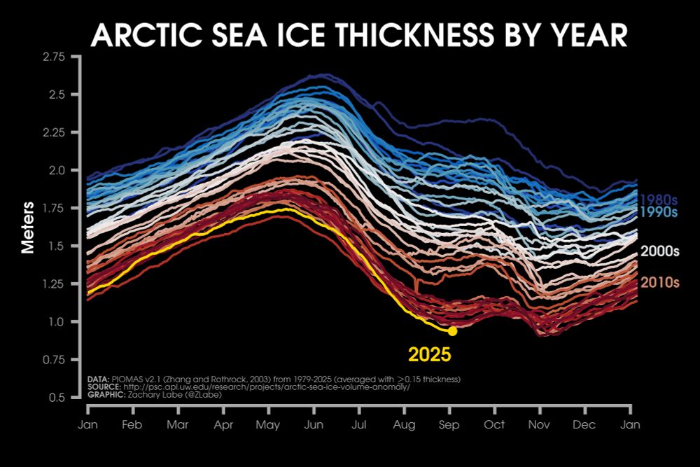
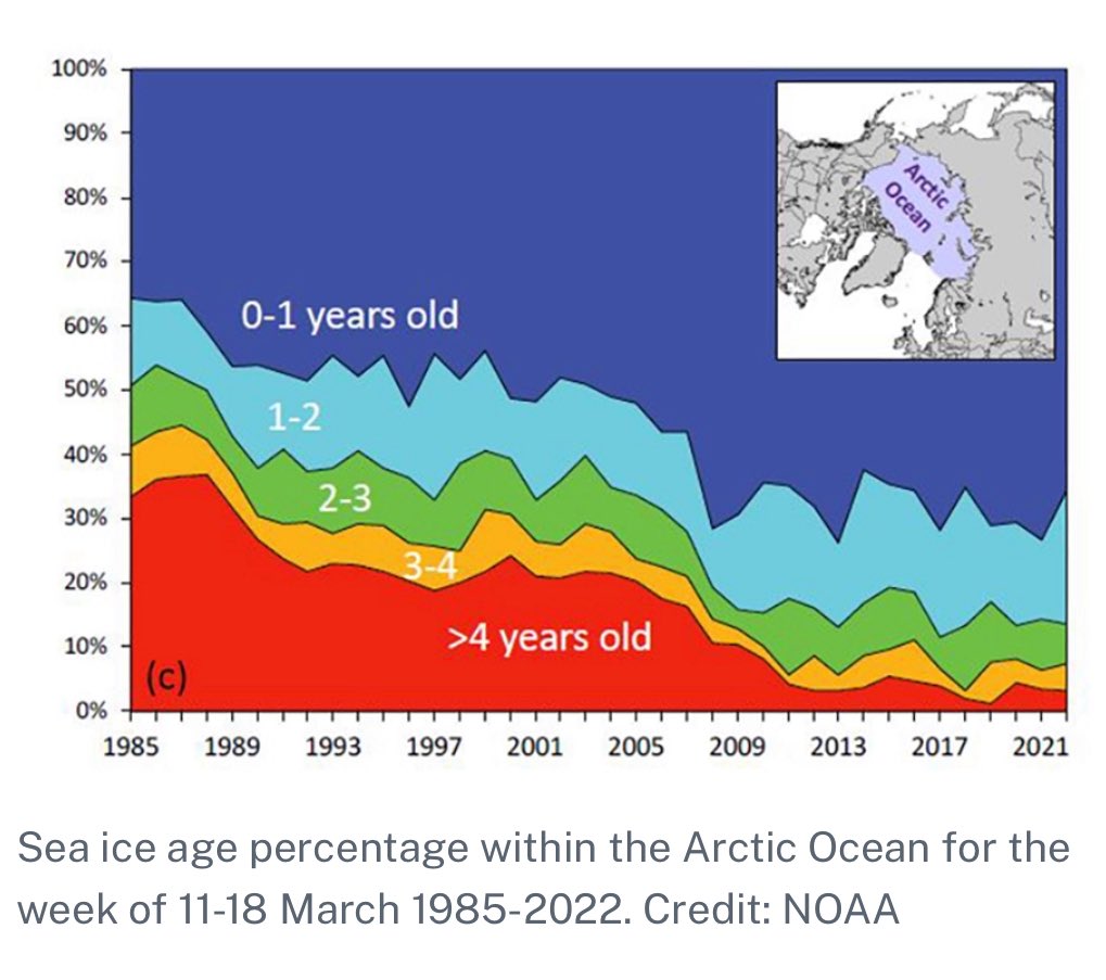
The volume is close to the lowest on record for this time of year since the ice is so thin due to the record MYI melt over the years. This allows the big disparity between extent and area. As the concentration is also near record lows.
Follow⚠️ While extent will not be setting any annual minimum records this year, the average thickness of #Arctic sea ice is actually at historic lows for this time of year (in the dataset by PIOMAS). Thinner ice is younger and usually more fragile. More graphics of volume: zacklabe.com/arctic-sea-i...ALTSeptember 10, 2025 at 8:07 AMEverybody can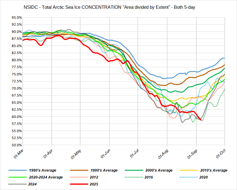

Yeah. Volume doesn't really tell you much about what's happening now. The low volume is the result of decades of warming. We could have an asteroid impact the planet today and cool it 3 degrees and the volume would still be low next year.
-
53 minutes ago, PhiEaglesfan712 said:
What about 57-58 and 09-10 (the two very snowy el ninos)? Were the 500mb height anomalies similar when adjusted for climate?
I never really compared those winters so I don't know without looking into it.
-
2 hours ago, 40/70 Benchmark said:
You absolutely nailed that...full credit. While my outlook went up in flames, it was one of the more instructional experiences that I have had in seasonal forecasting. This is why I always say the ones that are missed are our most valuable resources. We saw something similar with the 1972-1973 El Nino, but obviously this was warmer given CC.
I think this year we may see something similar in that seasonals will overbake ENSO into the output.
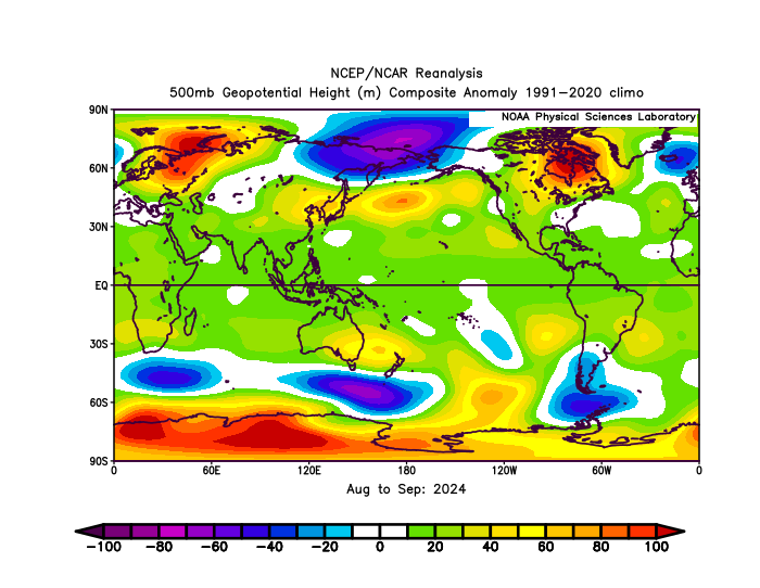
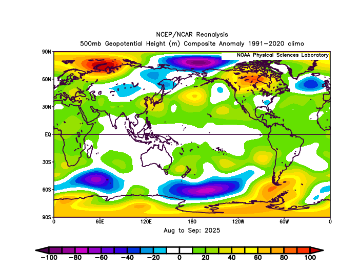
In the end, the 500mb height anomalies in 72-73 were very similar to 23-24 when you adjust for the current climate.
-
1
-
1
-
-
1 hour ago, HillsdaleMIWeather said:
This really is the best time of the year temperature wise
Yeah. The dewpoints usually aren’t real high and the longer nights allow it to start cooling down fairly early even if it does get really warm during the afternoon.
-
3 hours ago, michsnowfreak said:
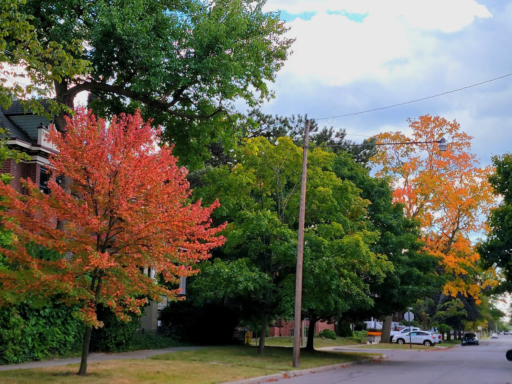
Exactly. Theres always a few stressed trees showing color by late August, but the amount of color for early September is clearly more than normal this year.
45F again at DTW. Its incredible how many upper 30s and low 40s the cold spots of SE MI have had the past 2 weeks.
The period of Aug 25 - Sept 7 (the last week of Aug & first week of Sept) was 6th coldest on record for Detroit, and coldest since 1935.
Mid 30s here this morning. I looked for frost on the rooftops this morning but didn't see any.
-
1
-
-
3 hours ago, TheClimateChanger said:
28F at the Water Treatment Plant in Wauseon yesterday.

Is that even possible?
-
5 hours ago, michsnowfreak said:
Color continues to expand. Seems like we will be looking at an early color show, especially if it stays dry.

Yeah. There’s a couple areas around here where there’s some groups of trees that have a decent amount of color. There’s always some trees with color at this time of year but I feel like it’s been awhile since there’s been this much color already in early September.
-
2
-
-
3 hours ago, snowman19 said:
2011-12 didn’t turn into an all out disaster until the end of November. A few days after Thanksgiving that massive Bering Sea vortex developed and just sat and spun there for months on end…right through April. It was one of the most persistent patterns I’ve ever seen. There was damn near close to consensus on east having another cold and snowy winter and all those forecasts busted horribly
If that happens this winter, I expect if someone working in an Antarctic research station posts a tweet about it, you’ll find it and post it here. lol
-
 2
2
-
-
21 minutes ago, michsnowfreak said:
Not sure about MUCH warmer than normal, but overall warmer than normal wouldn't surprise me at all. It actually fits perfectly with your expected nina. A mild Fall with a sharp turn colder in late November or early December is classic nina.
The caveat of course is that "warmer than normal" comes with rapidly cooling averages. Not sure how far south this applies, but for here at least, even a warm October is far from hot. A few days of low humidity 80s and a few frosts normally happen in warm Octobers.
I’ll take Nina over Nino every time around here in the winter. Hopefully we do have a “warm” October. It feels like a lot of times a cold October turns into a mild December. Although, that’s probably due to a cold October being more common in a Nino. A cold October is kind of useless anyway except for chasing the first flakes of the season or some sloppy early season slush accumulation that melts in a few hours.
-
1
-
2
-
-
57 minutes ago, bluewave said:
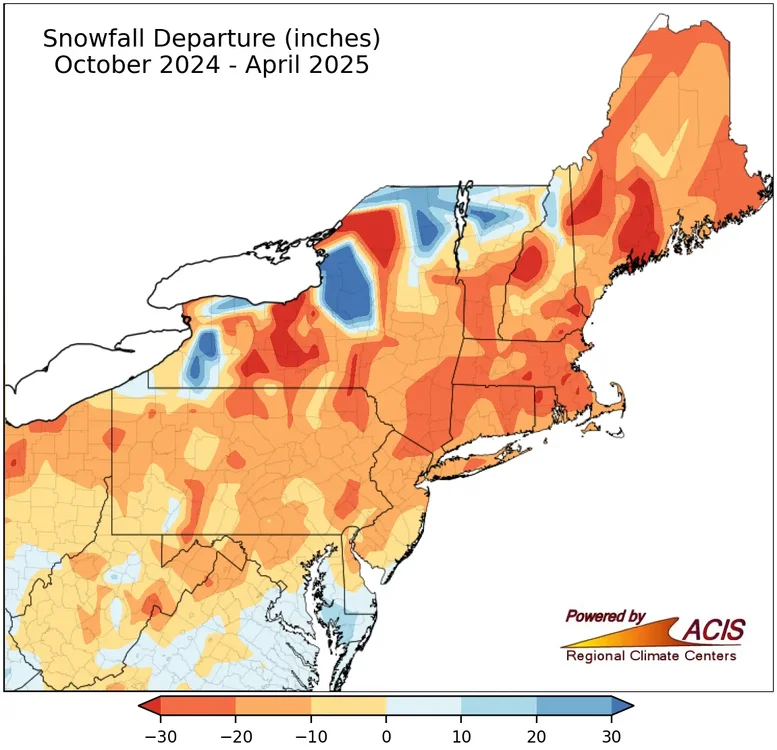
The much below average snowfall forecast from the seasonal models run during the fall of 2024 from Philly to Boston did work out. They even got the very low snowfall correct for Chicago.
That’s what most on here follow anyway.
A continuation of the warm storm tracks through the Great Lakes theme.
I’m pretty sure the model was forecasting all of that below average snow because it had a country wide blowtorch. So it was right for the wrong reason pretty much.
-
2
-
2
-
-
-
2 hours ago, michsnowfreak said:
Last week of August was 7th coldest on record at Detroit which plummeted the hot summer ranking out of the top 20.
August started cool and obviously ended very cool with just “heat” in the middle of the month which was more like very warm with obnoxious dewpoints. July was certainly hot overall but June was fairly cool until the last week to 10 days of the month. For all the talk of record setting ridges and all that stuff, it wasn’t even anything special for heat.
-
1
-
-
I gotta say. This cool airmass is impressive not only in strength but in duration. I mean, the sun has been set for about an hour and a half here and the temperature is already down into the 40s. That’s impressive for August even if it is at the end of the month.
-
1
-
-
2 hours ago, michsnowfreak said:
I also have a feeling the trees are really going to start taking off with these cool nights. Its not at all uncommon to see some stressed color by now, but I've been noticing many trees starting to get some color the last few days.
Yeah. I’m seeing that too. I remember a lot of early color in 2017 after that cool August and early September. Then it of course turned hot in late September as you know. lol.
-
1
-
-
3 hours ago, michsnowfreak said:
We had a warm, humid summer here, and while once again, extreme temps were not a thing (14 days of 90F+, which is only 1 day more than normal, and only 4 of these days were 93+) it was the warm humid nights that made their mark.
Yet now, we are in a stretch of a what will be about 10 days straight of unseasonably cool nights, several of them flirting in record low territory, so to say that summers back is broken is an understatement. The trees are starting to get some color as well.
Through yesterday, we are now at .4 above average for the month around here. Tomorrow will be well below average and the lows around here for sure will be below average the rest of the month. The highs might be too but Sunday might be close. I think we’re going to end the month slightly below average with the low temperatures leading the way which has become quite unusual in recent times.
-
3
-
-
2 hours ago, FPizz said:
Plenty of articles about that. But, maybe it is just a holding pattern for now, and then there will be another dip lower (or higher haha).
I still think that all of the extra water vapor/moisture around the globe(compared to a few decades ago)helps keep the summers cloudier and cooler there while keeping the other seasons warmer. Every year when October rolls around these days, the temp anomaly maps go from light blue to dark red. It just can’t cool down as fast as it used to with so much more moisture in the air. Having more open water than decades ago probably just adds to the moisture.


2025-2026 ENSO
in Weather Forecasting and Discussion
Posted
It was interesting to track 10 years ago, now it’s just boring.