

canderson
-
Posts
23,872 -
Joined
-
Last visited
Content Type
Profiles
Blogs
Forums
American Weather
Media Demo
Store
Gallery
Posts posted by canderson
-
-
19 minutes ago, MAG5035 said:
I saw this gem shared on my F-book feed. S&S needs to get their head in the game lol

I spit out tea when I saw this image.
-
 2
2
-
-
CTP hinting at a much lower impact for the LSV.
-
21 minutes ago, Bubbler86 said:
In refence to the cold?
Yup. I didn’t Goodfellas ya.
-
16 minutes ago, Bubbler86 said:
Some of us have to get out of the house tomorrow and will be living vicariously via mobile. LOL. It's been a long haul...some 6-10 models 4x a day.
Hope your car starts!
-
CTP's 11 am discussion is very detailed and a good read.
QuoteA closed mid-level low pivoting across the Gulf Coast early
Sunday morning will begin to lift northeast and take on a
negative tilt across the southern Appalachians Sunday afternoon
and then race northeast to be over NJ by 12Z Monday. This will
be accompanied by an increasingly coupled jet structure
downstream of the pivoting trough, with intense ascent through
diffluence aiding in the development and then strengthening of a
low pressure system moving north to a nearly stacked position by
the end of D3. The guidance has come into much better
agreement with the placement of this low lifting roughly along
the I-95 corridor. As this low initially develops, mid-level
confluence over the Mid-Atlantic will help reinforce a wedge of
high pressure down the east side of the Appalachians in a
typical Cold Air Damming (CAD) setup.As the low strengthens, moisture will surge northwestward
behind robust isentropic lift and likely produce a period of
moderate to heavy snow (WAA thump) early Sunday night (00-06Z
Mon). Mixed thermal profiles and possible dry slot are in play
into early Monday morning to the southeast of I-99/80 which
could transition snow to ice over the southeast part of the CWA.
While there are still some details to resolve, there is a
strong enough model signal to issue a well-collaborated winter
storm watch for most of the CWA from 18Z Sunday to 18Z Monday.
The multi-model/blended QPF and SLRs indicate potential for 6"
or more of snow with a minor ice glaze also possible across the
southeast 1/3 of the area.Deformation snow appears to linger over the northern part of CPA
through Monday morning. The expected snowfall btwn 12-18Z
Monday was not included in the storm total with this cycle
given that it is beyond the set time window. Expect cold/gusty
NW flow to take over Monday night with deformation snow
transition to lake effect/upslope snow showers into Tuesday
morning.Post-storm will likely feature a period of gusty northwest
winds and lake effect snow showers as cool temperatures remain
in place.-
 1
1
-
-
At this point I hope I get dryslotted fiercely.
-
So MDT is extremely likely looking at 1-2" snow, then a sleetfest and a little glaze of zr just to kick us when we're down?
I already despise this storm. BUUUUUT sleet >>>> zr with strong winds.
-
1 minute ago, stormtracker said:
Seems as the thread was accidentally deleted by the author...ahem @Bubbler86 Anyway, I restored it and merged
IS @Bubbler86A LONGCON RUSSIAN MOLE?!?!
-
 1
1
-
-
If I get 4” before 1-2” of sleet/zr I’d be ecstatic. I fear a huge bust and it’s a majority of a sleet storm. Wonder what 6” sleet looks like.
-
This is Valentines Day 2007 again but with less snow for the 81/78 corridor. That storm SUCKED.
-
1
-
-
Came to read the euro and 6z runs … what the heck happened?
-
10 minutes ago, MAG5035 said:
I’m just not sure winds that high mix to the surface. I could def see some 20-35mph gusts occurring in the Sus Valley pretty easily. I dunno about 50+ though.
Thank you. I pray you are correct!
-
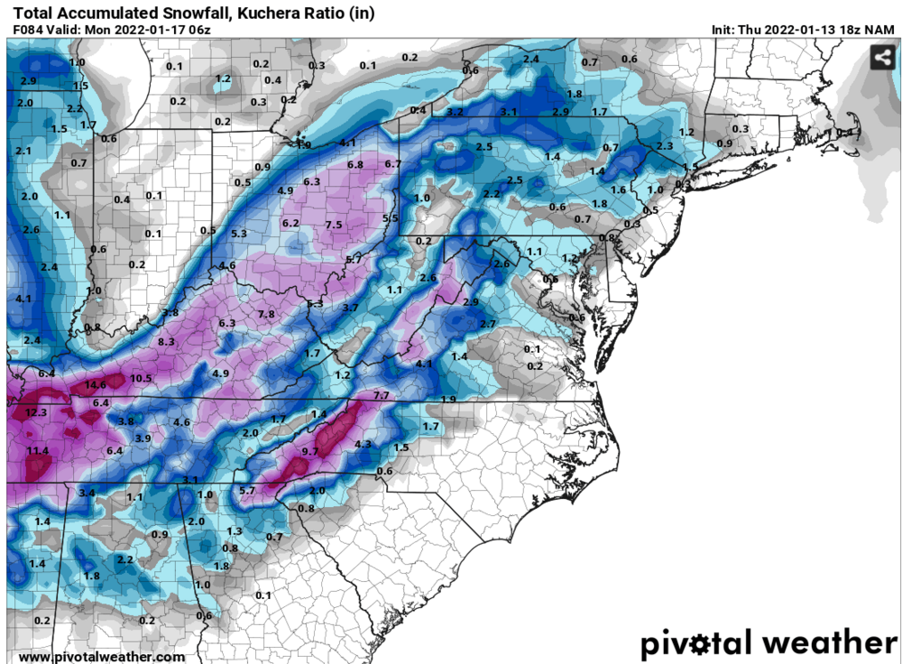
The GFS tonight decided not to head to Toledo like it did yesterday - good sign!
-
6 minutes ago, losetoa6 said:
I do think the winds and severity are being underestimated . Haven't heard much talk from mets .
Beating the dead horse hit winds will be the bigger issue here than snow. 6-10l isn’t a massive deal - sustained winds at 40 for 2 days and countless gusts maybe to 70 over that span is a nightmare.
-
60 mph winds with 1/4” ice in trees is catastrophic.
-
5 minutes ago, Voyager said:
I know, snow maps and all, but the NAM gave me a tenth of an inch of snow and six tenths inch of freezing rain.
Just think of the sleet as snow insurance.
-
This NAM gulf fetch is crazzzzzzy.
-
Just now, Blizzard of 93 said:
I thought about him earlier today - hope he’s ok.
-
2
-
-
2 minutes ago, Festus said:
If the winds verify, that's going to be as big or bigger story here. I haven't gusted north of 60 in a long time.
I think winds will be a much bigger story than snow. Mass power outages with near zero temps is a serious major issue.
-
3 minutes ago, Itstrainingtime said:
Thanks!
Fortunately, I don't live in Lancaster and my house is safely within the purple.
")
You’re in the county! The river will be the dividing line of snow. We all get 60-70 mph winds.
Its a cat 1 hurricane essentially .
-
6 minutes ago, Itstrainingtime said:
Just got home from work and saw this - between 8-9" at Harrisburg and Reading with less than 1.5" at Lancaster?
Could happen.
Probably won't happen.
If it does I’ll be kind and let you come shovel my snow. That way you don’t feel ripped off.
-
1 minute ago, Bubbler86 said:
I think that 60 is blowing through downtown Harrisburg.
I expect to lose some siding / shingles from this system. Sandy took off a bunch and this probably is windier.
-
I don’t recall a system ever behaving the way it is being depicted by the NAM - at least not since I moved to Pennsylvania 15 or so years ago. I can’t wrap my head around a low near savannah hooking so far NW Erie gets plain rain.
Edit: NAM/ICON, not GFS
-
Central PA - Winter 2021/2022
in Upstate New York/Pennsylvania
Posted
Wasn't there a storm recently that was to feature heavy sleet that the Euro was showing as snow? 2019 maybe?