

dryslot
-
Posts
58,530 -
Joined
-
Last visited
Content Type
Profiles
Blogs
Forums
American Weather
Media Demo
Store
Gallery
Posts posted by dryslot
-
-
5 minutes ago, #NoPoles said:
WSW hoisted for my area
URGENT - WINTER WEATHER MESSAGE
National Weather Service Gray ME
Issued by National Weather Service Caribou ME
351 PM EDT Mon Apr 1 2024

MEZ007-008-012-013-018>021-024>026-033-020800-
/O.NEW.KGYX.WS.A.0008.240403T1800Z-240405T1000Z/
Northern Oxford-Northern Franklin-Southern Oxford-Southern
Franklin-Interior York-Central Interior Cumberland-Androscoggin-
Kennebec-Coastal Cumberland-Sagadahoc-Lincoln-Interior Cumberland
Highlands-
Including the cities of Gray, Bethel, North Windham, Oquossoc,
Windsor, Berwick, Gorham, Boothbay Harbor, Milton, Alna,
Farmington, Hanover, Alfred, Wilton, Bowdoinham, Sidney, Roxbury,
Goodwins Mills, Coburn Gore, Bridgton, New Vineyard, Greene,
Wiscasset, Phillips, South Portland, Limington, Newcastle,
Vassalboro, Norway, New Gloucester, Middle Dam, Fryeburg, Avon,
Harrison, Rangeley, China, Westbrook, Upton, Bristol, Bath,
Naples, Sabattus, Dresden, Davis, Newry, Lebanon, Temple, Buxton,
Kingfield, Waterville, Whitefield, Topsham, Damariscotta,
Yarmouth, Waldoboro, Turner, Sanford, Lewiston, Hollis, Livermore
Falls, Oxford, Portland, Bryant Pond, South Arm, Bowdoin,
Chesterville, Wales, Jay, Augusta, Phippsburg, Byron, Palermo,
Locke Mills, Minot, Cape Elizabeth, Bremen, Wilsons Mills,
Andover, New Sharon, Rumford, Brunswick, Auburn, and Arrowsic
351 PM EDT Mon Apr 1 2024

...WINTER STORM WATCH IN EFFECT FROM WEDNESDAY AFTERNOON THROUGH
LATE THURSDAY NIGHT...

* WHAT...Heavy snow possible. Total snow accumulations greater than
  18 inches possible. Winds could gust as high as 55 mph.

* WHERE...Portions of south central, southwest, and western Maine.

* WHEN...From Wednesday afternoon through late Thursday night.

* IMPACTS...Visibilities may drop below 1/4 mile due to falling and
  blowing snow. The strong winds and weight of snow on tree limbs
  may down power lines and could cause scattered to numerous power
  outages. Significant snowfall and periods of heavy snowfall rates
  will combine with low visibility to create very dangerous driving
  conditions. The hazardous conditions could impact the Wednesday
  evening and Thursday morning commutes. Gusty winds could bring
  down tree branches.

PRECAUTIONARY/PREPAREDNESS ACTIONS...

Monitor the latest forecasts for updates on this situation.

&&
-
 2
2
-
-
I’m going topless

-
2
-
 1
1
-
 4
4
-
-
12z Euro pretty similar to the 06z run taking a quick look.
-
1
-
-
2 minutes ago, weatherwiz said:
I hardly ever look at the Canadian but this would be pretty sweet if that verified. That would be a nuking for some

Its probably not a bad thing.
-
2
-
-
Even the models are onto april fools day.
-
2
-
-
Congrats Dendrite?

.thumb.png.d3f2f9fce09692ae5feb390f9c381772.png)
-
2
-
-
2 minutes ago, 40/70 Benchmark said:


-
2
-
5
-
-
Looks like the CMC stayed home today.
-
1
-
-
Just now, MaineJayhawk said:
I doubt anything that falls after sunrise Friday is snow - pretty light rates - but before that is certainly a hoot
Yeah, The higher sun angle above prevents it this time of year but there is a pounding in there before hand.
-
-
Just now, Ginx snewx said:
These never come south... Holy shit Jeffafafafa on the GFS
I was waiting to post the clown map but it was still snowing @ 03z sunday...............
-
Phinn gets 50"+ lol
-
1
-
-
Days and Days on the GFS.
-
Convection has a way to screw things up i know when lows are moving off the coast, This happening that far west, Don't know how its going to affect the secondary to the east.
-
12z GFS a couple more tics further east with the secondary, Gets captured east of PSM and gets tugged back west, Still going too.

-
The other thing i've notice is this has slowed down a bit from the past couple days, Start time here is late weds afternoon.
-
1 minute ago, Ginx snewx said:
Yea north while you are under blizzard conditions. At least try to let the runs finish before you add your depressive takes.
Still going verbatim.
-
Reggies output would work quite well for many if it wasn't the reggie and was another model showing that output.
-
Just now, CoastalWx said:
Thought you don't want snow. Should embrace it.
I didn't, I don't think its going to matter what i want actually, I have some work to do that i was hoping not to have to do because of it, I can't take the chance of having some damage when i have a chance to avoid it.
-
1
-
-
Just now, wx2fish said:
Nam is pretty much a swfe with a deep 700 low tracking up the St. Lawrence. Type of setup where it could be snowing at PSM, while it's sleeting into the Central Greens for a time. Regardless, not getting big totals in NE with that ML track
I wouldn't go as far as totally discounting its output, But i'm not going to endorse it either unless some other models move towards it, Its a pretty far west outlier ATTM and still out around 60hrs.
-
1
-
-
A little more wiggle room still here having a little more latitude helps, But the 12z NAM did go a couple tics east of the 06z run it looked like.

-
Just now, tamarack said:
The spreads in the GYX snowfall predictions are huge - 90%/expected/10% for Farmington are 4/8/20. MHT <1/4/13. Lots of uncertainty still.
Yes, And i mentioned that earlier when i posted that map and reading the AFD, I gathered the same.
-
1 minute ago, PowderBeard said:
Ouch, that could have ruined the season. Ill be happy just getting mine loaded and fired up on muffs next weekend. It is currently in the garage buried under all about 20 Plano cases, 40 lbs of plastic baits, and a couple dozen rods. Guess it is time to start the annual fishing thread.
Brothers in the marine repair business, Ours is all ready to go, Both motors have been summarized.
-
Just now, PowderBeard said:
Yup! At least it will be pushing 50* afterwards. My concern now is the boat ramps. My first bass tournament of the year is in two weeks.
Ha, Well my plans were to be on the lake next weekend, My boats in Alfred at my brothers, He just unwrapped it but he had a branch off a 200 yr old maple fall all across his yard and missed the boat by 3' from that last storm where they got ice when we had the sleet, So he's cutting that up today so i wont go down to get it until next week now but i'm ready to fish.
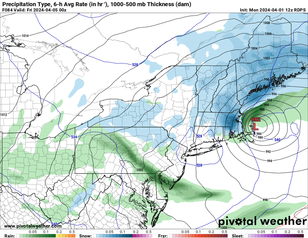
.png.8365200351b4ea3e9a31f2239e4df9d1.png)


Significant Miller B Nor'easter watch, Apr 3rd-4th
in New England
Posted
Ran the generator, All good.