

dryslot
-
Posts
58,506 -
Joined
-
Last visited
Content Type
Profiles
Blogs
Forums
American Weather
Media Demo
Store
Gallery
Posts posted by dryslot
-
-
2 minutes ago, wxeyeNH said:
That map is confusing to me. Look at Plymouth NH. Most people see the 8-12". Looking at the side bar Plymouth is in the 12-18" with lollies to darker reds over 18". There has got to be a better way
If you hit the point forecast on that graphic it gets more specific of where some fall in that grid.
-
 1
1
-
-
2 minutes ago, PWMan said:
I was tempted to spam my friends and family with the 1-in-10 map showing 21" for Portland.
That BTV precip onset map really is something. And of course the whole purpose of maps like that is to help the general public plan. Yikes.
Wait to spam them with the 18z HRRR one instead, That model is very cold.
-
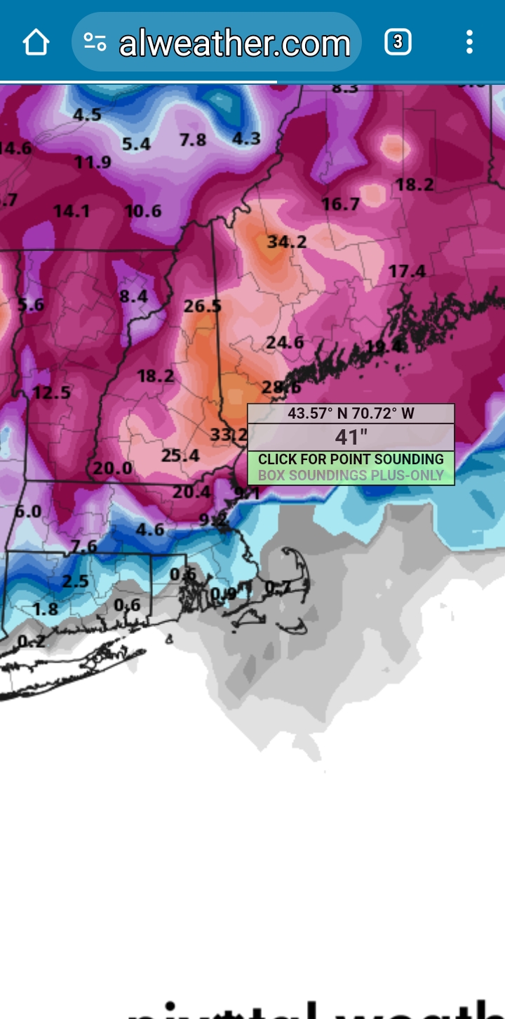
A bit easier reading the colors on this map.........

-
1
-
-
4 minutes ago, tamarack said:
GYX table of 90%/expected/10% still shows lots of uncertainty:
PWM #: 0/6/20
ASH #: >1/5/16
Less of a spread at Farmington: 13/18/25.

-
CMP is booking all available hotel rooms here locally
-
8 minutes ago, SJonesWX said:
I hope there aren't any Buffalo Bills fans nearby
They’re too busy, jumping off the Tobin after the Stefon Diggs trade
-
 1
1
-
-
Already getting numerous alerts of closures for tomorrow.
-
Some -SHRN with the moisture off the Atlantic here, 37/31F.
-
5 minutes ago, AstronomyEnjoyer said:
You're right. I need to set out a decoy table.
8’ table below your deck would work
-
3
-
-
-
2 minutes ago, CoastalWx said:
Euro is paltry on QPF. Either a big win, or glue factory.
It looked like it’s having some convective feed back issues

-
1
-
-
Just now, tunafish said:
Wonder how the color gradients are for old eyes?
Don't know, I can't see behind the large font lol
-
2
-
-
4 minutes ago, tunafish said:
Good lord. I hope they take that graphic out back and shoot it.
They made it for old people to read with that 24 font..............

-
2
-
-
5 minutes ago, CoastalWx said:
Rips my face off here. Ray offering shitty support to clients tomorrow if correct.
Shit face?
-
2
-
-
OVC, 38/32°F, Some moisture feeding into here off the atlantic on a easterly fetch.
-
Just now, tunafish said:
You sure you wouldn't prefer a model without an STD?
Don't they still have antibiotics?
-
2
-
-
I'm riding the herpes model
-
1
-
-
Just now, ma blizzard said:
For marginal areas, you'd want the convection to really get going and get as organized as possible this afternoon .. would go a long way overnight to have a more uniform area of big lift as opposed to a more banded structure
That's the wild card really, Convection plays different rolls good or bad, If the precip field has that convective showery look to it that generally does not bode well for results.
-
1
-
-
Just now, weatherwiz said:
yup going to be interesting to watch that evolve later on
I was just telling a coleague that here that it will be interesting, As that will affect the slp track a bit east or west or where its modeled now.
-
1
-
-
1 minute ago, weatherwiz said:
Not too long until we start seeing those
Some of those are where that secondary is going to develop around the delmarva.
-
2
-
-
1 minute ago, Ginx snewx said:
Asking again, any insight into new Rapid Refresh @OceanStWx
.thumb.png.778745b741bcef208a3674045fe14a27.png)
Yeah, I'm not sure on that and would have to defer to the mets that know.
-
Further south TOR watches are up from SPC for some areas.

-
Just now, Ginx snewx said:
Holy crap

Run after run for days and days.
-
Already getting some light precip moving in here on easterly fetch off the Atlantic on radar.

-
4
-


.png.65b030e6496907b83a5da7f51639d115.png)
Significant Miller B Nor'easter Apr 3rd-4th OBS
in New England
Posted
They just toned it down a bit, But not a lot.