

dryslot
-
Posts
58,530 -
Joined
-
Last visited
Content Type
Profiles
Blogs
Forums
American Weather
Media Demo
Store
Gallery
Posts posted by dryslot
-
-
Quite bullish on the 06z GEFS

-
 1
1
-
-
1 minute ago, CoastalWx said:
Looking forward to pics of day care toys in snow.
Its looking more likely, Models have ticked colder too up here.
-
1
-
-
No changes.
-
2 minutes ago, RUNNAWAYICEBERG said:
No math needed for many in sne on that AI run.
Warm here too, Foothills mtns get smoked.
-
Even at 7-8:1, Do the math

-
2
-
 2
2
-
-
As much as i don't want anymore of it, Were in the prime spot for it.
-
3 minutes ago, tunafish said:
I have 0 reason to be confident in my location for this, but I am.
East winds certainly are not your friend.
-
1
-
-
2 minutes ago, Prismshine Productions said:
Yeah, which benefits everybody overall with a colder column
Sent from my SM-S146VL using Tapatalk
Whether its rain or snow, It will by high impact, Wind and storm surge from the east just enhances things too.
-
1 minute ago, Prismshine Productions said:
Yeah, 2m temp avg cooled off by a full degree Celsius vs 12z
Sent from my SM-S146VL using Tapatalk
I think you will see this continue as we get closer,Most of the time, These trend colder in the end.
-
Looking at the 18z GEFS we start out mid 30's on weds with temps dropping into the 20's at the surface as some of the heavier precip falls Wednesday night into 12z thursday as the low gets cranking.
-
1
-
-
1 minute ago, NW_of_GYX said:
Ya it’s a much different system than last weekends. If I had to guess I’d say the winners will be further south than the last one
I agree.
-
1 minute ago, powderfreak said:
Yeah, I want that energy and players to be onshore, on the field in data rich environments. Not saying it’ll happen but Day 5, thing could still bomb out and crush like central PA or go out to sea.
Its a stout block so escaping ENE is on the table or even a push further south.
-
1
-
-
Just now, CoastalWx said:
I have been savagely beaten last two years.
Some of these projected SLP positions are pretty favorable for you if the air mass cooperates though.
-
1 minute ago, CoastalWx said:
Can’t do it
Deep down we know though.
-
1 minute ago, powderfreak said:
Nothing like these snow maps at Day 5 to give that final kick in the nuts this winter, ha.
At this lead, There's going to be a siggy system on the EC, Details still TBD going forward.
-
1
-
-
2-3" modeled qpf though, Amazing how wet these systems have been all winter.
-
2
-
-
Just now, powderfreak said:
I don’t like when there’s like 20” of difference between 10:1 and the positive depth maps.
The kuchera may be of better use, Some are not seeing 10:1, In fact probably many.
-
One of the strongest signals for a HECS from this lead time that i have seen.
-
4
-
-
Scooter with 28" plus hope he's not buying in.
-
I guess 18-24" is a step back from 30"
-
1
-
 2
2
-
-
4 minutes ago, kdxken said:
"What may bode well too is there isn't a cluster cluck of shortwave mess"
For the first time in like forever.
No, It’s a slp around 970mb crawling ENE.
-
2
-
-
5 minutes ago, weatherwiz said:
That is a pretty damn near textbook evolution of the 500mb pattern and how H5 closes off and where it tracks.
What may bode well too is there isn't a cluster cluck of shortwave mess. There's plenty of shortwave energy around but only a few distinct major pieces.
If you're outside of the far interior and don't have elevation, dynamics are going to be critical but there is plenty of cold air available not far away.
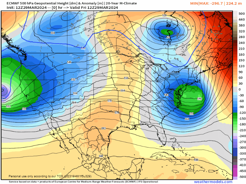
A thing of beauty.
-
1
-
-
8 minutes ago, WinterWolf said:
It’s gonna jump around…it was only a slight shift. Watch the ensembles.
Couple tics south
-
2
-
-


Significant Miller B Nor'easter watch, Apr 3rd-4th
in New England
Posted
Pretty far north actually.