

dryslot
-
Posts
58,502 -
Joined
-
Last visited
Content Type
Profiles
Blogs
Forums
American Weather
Media Demo
Store
Gallery
Posts posted by dryslot
-
-
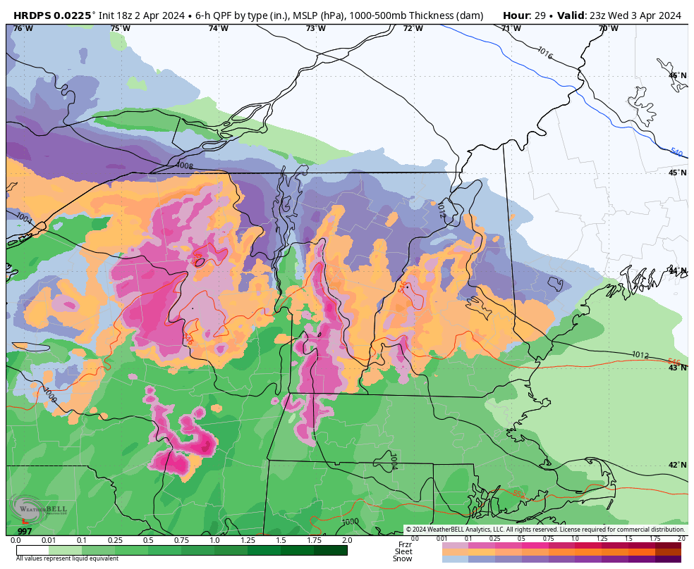
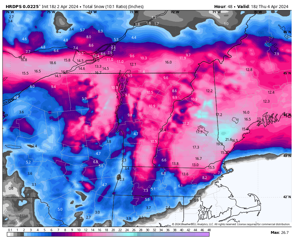
Looks like some increase in snow totals is coming for some areas.
NEAR TERM /UNTIL 7 PM THIS EVENING/...
1030am Update...Steady precip will begin re-entering SW NH this
morning. Dewpoint temps back here, sheltered from strong low
level NE winds, are well in the 20s yet. This creates a large
dewpoint depression and will likely see temperatures drop back
into the 30s once precip begins. This should result in a daily
mix of rain/snow/sleet for much of the area that sees precip
through this afternoon. Some impressive downslope winds already
in the lee of the Greens/Berks, and will likely be increasing
winds similarly this afternoon for the Monadnocks up through the
Whites. Local guidance really increases winds towards
Whitefield this evening and overnight, with some peak gusts
toward 45 or 50 mph possible. Will be perusing morning guidance,
but increase in local QPF values up interior ME and the coast
is probable. Low level FGEN has trended a bit steeper than
yesterday, and very high 00z HREF probs show that most of the
Lakes Region and southern coast of ME will see at least 8" of
snow by 8am Thursday. This includes the population corridor of
York/Cumberland counties. Thus an increase in coastal snow
amounts is likely for this afternoon`s package, but would still
expect a very tight gradient.
-
 1
1
-
-
GFS has been locked in on this event whether it is right or wrong.
-
4
-
-
2 minutes ago, weatherwiz said:
This is why the P-type maps can suck too and not great to use. Given how cold it is aloft, combined with some dry air, it isn't surprising many are seeing sleet or sleet mixing in.
You have to look at soundings to get a clearer picture of whats going on aloft, This is a good candidate for a nowcasting event.
-
2
-
-
Just now, HoarfrostHubb said:
I would be if my local ski hill was still open...but they closed this past weekend
If i was still riding i would be very giddy about another couple trips, But that shipped sailed in late march.
-
1
-
-
The Nam sucked ass in the 3/23 storm up here and its already wrong in areas that are pelting now that showed rain..............lol
-
5
-
-
The new buzz phrase is the PDC maps.
-
 1
1
-
-
The SLP is taking its time to get going is allowing for a warm air intrusion in the mid levels before it gets pinched off on the Nam that happens rather quickly.
-
Just now, MJO812 said:
Not a snow weenie ?
Not in napril.
-
 1
1
-
 1
1
-
-
3 minutes ago, WinterWolf said:
C’mon …you’re pumped about this..no? How can ya not be? I’d be if it was here. It’ll melt in no time.
Not really, Who cares about padding stats? But i do like the potential severe aspect to it.
-
2
-
-
To bad the DGZ wasn't dry the whole storm.
-
Looks like it may be more snow/sleet here verbatim.
-
Tsunami across Paugus Bay.
-
1
-
-
Lays down a bong here.
-
1
-
-
5 minutes ago, MaineJayhawk said:
What isn't GW in my 'hood? JFC
None of them.
-
Sell a horse.
-
1
-
-
GFS has remained steadfast for this area as i mentioned earlier for several cycles.
-
1
-
-
23 minutes ago, powderfreak said:
The Reggie version of the HRRR seems super warm tomorrow evening.

Edit, but recovers nicely lol.
The column collapses quickly by the time it gets up here, That's been well modeled over all guidance several days here.
-
1 minute ago, PowderBeard said:

You have a genny i presume?
-
1
-
-
1 minute ago, SouthCoastMA said:
near average after this one?
If it’s right, Close to it.
-
2
-
-
-
-
WSW hoisted.
-
2
-
-
1 minute ago, dendrite said:
@tunafish can make last call and then do his PWM measurement.
With a tilt to it or upside down?
-
1
-
-
1 minute ago, dendrite said:
Correct. But climo data doesn’t change. Everything still runs 5z-5z (1am-1am EDT)
Yes, When the bars close..............

-
1
-


Significant Miller B Nor'easter watch, Apr 3rd-4th
in New England
Posted
OVC here, 37/31°F