
dryslot
-
Posts
62,842 -
Joined
-
Last visited
Content Type
Profiles
Blogs
Forums
American Weather
Media Demo
Store
Gallery
Everything posted by dryslot
-
Obviously, But were going to be a few hundred miles from the center here and typically would see nothing.
-
The weather station is 6' up on the roof peak and its in a wide open area with no trees, So i have narrowed it down to rates as when i have inspected it in the past, There is nothing in the tipper that would impede the catch.
-
Looks like the weekend is going to be quite gusty up here being in the gradient between Fiona and the HP to the west, Gust could reach 50mph+ for the elevations.
-
Between my tipper on the weather station and the stratus gauge, It can be off a few cents depending on rainfall rates and it seems like the tipper under catches often, So i always rely on the stratus as long as i don't forget to empty it....lol.
-
1.94" in the tipper, 2.0" in the stratus, We wet.
-
Been +RN for the last 2hrs, 1.43" in the tipper so far.
-
+SHRN, 55/52°F
-
All i have is comprehensive that I've attached.
-
Read above, I was thinking rainfall, I agree on temps though, Its slightly below temp wise here as well.
-
I thought he was talking about rainfall totals, Temps i wouldn't disagree on.
-
Really? Today is only the 19th.
-
Radar last night indicated that area would do well
-
53/50°F this morning and overcast, Had 0.37" qpf overnight.
-
Yes
-
Had it in the wrong thread so i moved here where it belongs.
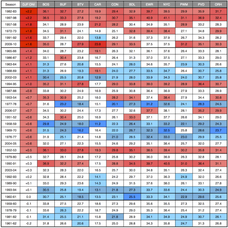
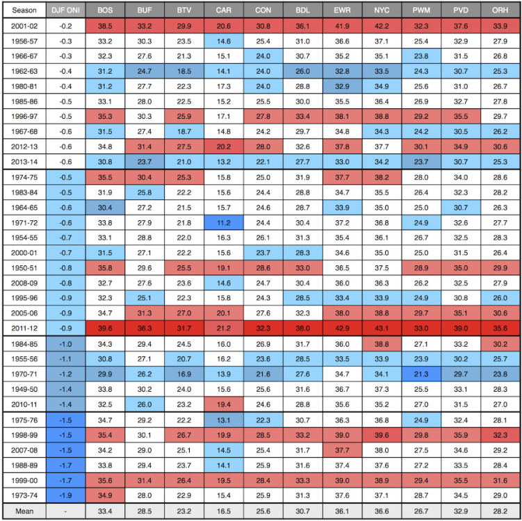
-
So are we.
-
Yup, Fall is definitely here, May still be some warm days here and there but summer is over.
-
We made it to 64.8°F, I think that's going to be about it for the high, Slipped back to 62.8°F now.
-
Sharks.
-
Most do.
-
https://www.facebook.com/100020506526199/videos/441399351349902/
-
Hit up my buddy yesterday for some crab meat and scallops, This was today's lunch at work, Nothing like fresh picked.
-
Septembers of yore.
-
Winds are suppose to dissipate here after midnight tonight, That's when i think the the overnight low temps will start to respond
-
Going to be a chilly one overnight. This Hazardous Weather Outlook is for Maine, south central Maine, southwest Maine, west central Maine, western Maine, central New Hampshire and northern New Hampshire. .DAY ONE...Today and tonight. Hazardous weather is not expected at this time. .DAYS TWO THROUGH SEVEN...Saturday through Thursday. Cool Canadian airmass will bring the possibility for the first frost or freeze across low-lying interior areas Saturday morning. Confidence is highest for temperatures to drop to the freezing mark across the valleys of Coos County and the Western Maine Mountains. Low to mid-30 temperatures are expected in the foothills regions with upper 30s for areas closer to the coast. Frost and freeze headlines could be issued on Friday for Saturday morning. Gardner`s should plan to protect any late season sensitive plants. .SPOTTER INFORMATION STATEMENT... Spotter activation is not expected at this time.