

mappy
-
Posts
45,137 -
Joined
Content Type
Profiles
Blogs
Forums
American Weather
Media Demo
Store
Gallery
Posts posted by mappy
-
-
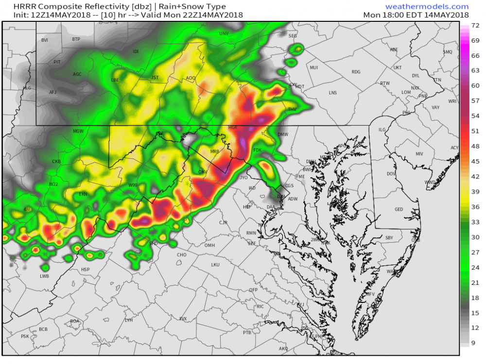
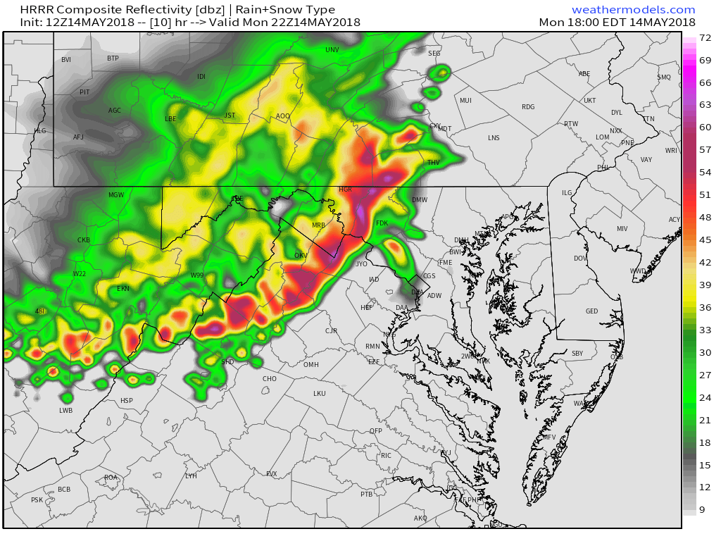
14z HRRR looking better.
12Z NAM seems to slowed down by an hour compared to 06z... 6-7pm the line drops out of PA.
-
 1
1
-
-
6 minutes ago, vastateofmind said:
Not the best shot of the last night's approaching shelf cloud (snapped just before 6:30 p.m. IMBY), as it was almost ready to move directly overhead...but you can see some of its movement at mid-screen. At that point, I think FfxCo was also under a tornado warning, so those cheesy-looking, grey/green clouds just above the treeline gave me pause.

great video! Yup, green is a tell tale sign of updrafts, in this case, lots of hail. rotation was very broad.
-
2 minutes ago, yoda said:
13z HRRR is better... not sure about severe... but storms are around us
yeah looks like it doesn't come together until its south of me (boo). but at least it has a decent line forming.
1 minute ago, vastateofmind said:Really interesting to hear the derecho talk this morning...in looking at radar around 6:30 p.m. last night (and I could kick myself for not grabbing a screencap), there appeared to be a prominent bow echo, with the leading edge bearing down on the Alexandria/Belle Haven area, then bending back over the District to the north and PWCo to the south. Some excellent pics of shelf clouds associated with last evening's derecho or near-derecho, too, on Twitter today.
I don't know the clear definition, as there seems to be a new proposed one going around too. Discussion seems to be based on that.
-
2 minutes ago, DCTeacherman said:
Where do you get these zoomed in convective outlooks?
http://www.spc.noaa.gov/public/state/images/
-
1
-
 1
1
-
-
lot of fun discussion about it this morning.
-
Id wait until NWS comes out saying so, but perhaps it was.
-
1
-
-
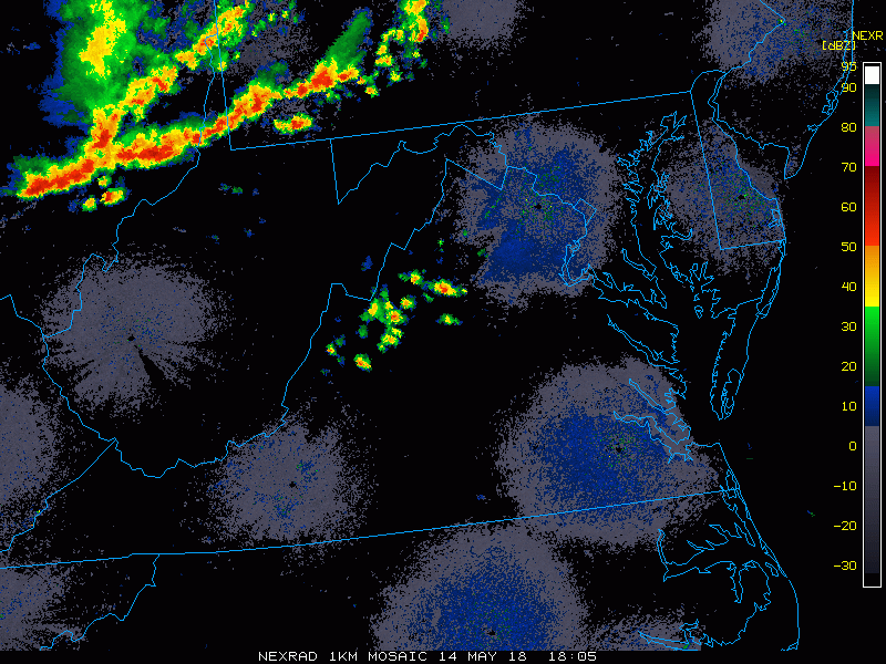
Combo of high EML, and CAPE, should provide enough for storms dropping out of PA to gain strength. Just need them to come through earlier in the evening rather than later.
HM on twitter earlier
-
1
-
-
updated day 1
15% wind 15% hail 2% tornado runs along the PA line
One source of uncertainty in this scenario is an area of outflow to
   the south, across parts of VA/MD/Delmarva and eastern PA,
   originating from yesterday's MCS, and sampled peripherally by the
   12Z IAD sounding.  Airmass recovery is expected from the southwest,
   around the northwest rim of that outflow pool and south of the
   morning convective/frontal baroclinic zone.  Expect midday to
   afternoon preconvective destabilization arising from both theta-e
   advection and diabatic surface heating.  68-70 F surface dew points,
   such as forecast by the NAM, may be overdone considering the
   available recovery trajectories, and the nearest dew points that
   large are 300-400 nm away over NC, on the other side of the outflow
   pool.

   Regardless, a plume of EML air advecting over this region will
   foster steep midlevel lapse rates, overlying strengthening
   boundary-layer lapse rates and low/mid-60s F surface dew points.
   That combination still supports peak MLCAPE in the 1500-2500 J/kg
   range, amidst strong west-southwesterly mean-wind and deep-shear
   vectors.  Forecast soundings suggest that, despite a nearly
   unidirectional vertical wind profile, effective-shear magnitudes of
   45-55 kt may be realized.  Downward momentum transfer from strong
   flow above 700 mb, into a well-mixed preconvective boundary layer,
   should offer favorable conditions for severe thunderstorm winds.
   Given the strong westerly component of the near-surface flow,
   more-unstable inland air may be shunted eastward to very near the
   coast across much of the region, extending the severe threat
   accordingly, before the MCS encounters too much stable marine-layer
   air and weakens.
.png.3178d9c84c1efc326be114bfb949379d.png)
-
7 minutes ago, Eskimo Joe said:
lol at the 6z GFS precip...we won't get a quarter of that. Meso guidance is a real snoozer today locally, even looks north of here.
i mean i guess if you are only looking at the HRRR, sure.
-
9z HRRR is a real snoozer for today. 06z NAM has a line dropping south around 23z-00z
-
Based on radar, I think the initial enhanced zone from 13z outlook should have stayed. But who knows...
-
12 minutes ago, losetoa6 said:
I think we still see garden variety stuff up here regardless . The derecho really didn't effect my yard back in 2012 . It was well south ...this feels and looks to hit those same areas .
Fine by me
-
1
-
-
Unless the line grows on it’s northeast side, I won’t see much
-
I think worst will stay south of me, not to say i won't get something out of it, but i have a feel the more severe stuff will be south.
-
wouldn't surprise me if we get long lead warnings with the line.
-
not bad of a line
-
Pitt did a SPEC too, at noon.
-
need the clearing to happen soon, 68/65 at home right now
-
Yeah, they are all over the derecho potential. i like it.
-
what'd i say earlier?
")
-
1
-
-
need to watch tomorrow too.
-
12z NAM says what storms?
-
Lets do this.
-
7 minutes ago, Kmlwx said:
Almost looks D-word-ish. But then again...it's the HRRR
SPC all but said the word derecho in their outlook. I wouldn't rule it out, at least a long lived squall dropping south out of the PA/Ohio area.
Pitt WFO is doing a special sounding today.
2018 Mid-Atlantic General Severe Discussion
in Mid Atlantic
Posted
EML looking good too.