

mappy
-
Posts
45,137 -
Joined
Content Type
Profiles
Blogs
Forums
American Weather
Media Demo
Store
Gallery
Posts posted by mappy
-
-
beautiful
-
 2
2
-
-
2 minutes ago, bdgwx said:
Probably splitting hairs, but that looks like a 35" contour on Wilmington.
technically Wilmington is within the 35" contour, so it would be 35"+
-
1
-
-
Just now, ag3 said:
Never said it was. Just gives credence to several other models who have shown this type of stall just offshore and then drift south.
I understand that, but just yesterday people were tossing the GFS run that did the exact same thing the Euro did. So which is it? The Euro yesterday, or the GFS today?
The ridge is the big player here -- and I honestly think up until it gets to the coast, those details, the slowing down/strength/stall/where it goes, will literally be worked out last minute.
People need to be careful making definitive statements.
-
6
-
-
1 minute ago, ag3 said:
Just remember the old version GFS has had a stall off OBX and then drift south for many days (before today's 12z run).
Several other models have shown this type of scenario one way or another as well.
This is the 1st time the Euro has shown it. Definitely could be a trend starting.
one run outcome is not a trend, nor can one say its a the start of a trend.
-
1
-
 1
1
-
-
8 minutes ago, NJwx85 said:
Didn't realize that, however the point is still the same.
check next time that you are posting the right information.
-
23 minutes ago, MikeB_01 said:
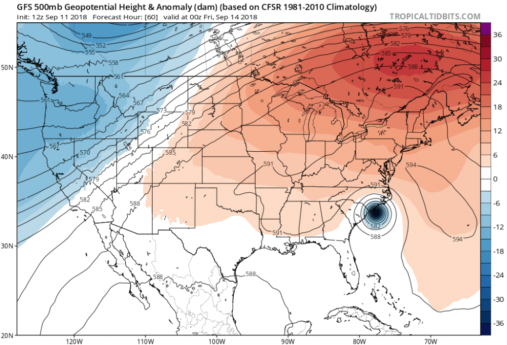
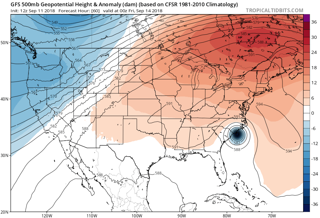
Maybe someone can help me understand this. I am looking at the steering layers and see a pretty clear path into eastern carolina - seems to be inline with where the majority of the models were yesterday. GFS moved away from there today and close to the Euro. Can anyone maybe point to something that would be driving it further south contrary to what it looks like in the steering layers of the atomosphere?
The ridge to the north is keeping the storm south. see the red area. the gfs had this weaker, and not as far west, in previous runs, thus it allowed Florence to come up the coast more. The ridge expands west as the run goes on, which causes the stall and the eventual inland movement of Florence. The Euro has had the same depiction.
-
1
-
-
4 minutes ago, OUGrad05 said:
I'm a bit concerned that as the storm widens and possibly re-intensifies that these storm surge projections may prove too conservative. While I don't think over-forecasting is a good idea either, I would think mentioning the possibility of intensification and moving those storm surge amounts higher would be good practice in this situation.
I'm not sure how the NHC can be more proactive in its warning for surge/flooding than this:
1. A life-threatening storm surge is likely along portions of the
coastlines of South Carolina, North Carolina, and Virginia, and a
Storm Surge Watch is in effect for a portion of this area. All
interests from South Carolina into the mid-Atlantic region should
ensure they have their hurricane plan in place and follow any advice
given by local officials.

2. Life-threatening, catastrophic flash flooding and significant
river flooding is possible over portions of the Carolinas and
Mid-Atlantic states from late this week into early next week, as
Florence is expected to slow down as it approaches the coast and
moves inland.
-
2 minutes ago, Raine1212 said:
Was not sure were to ask this? I am in Evans, Ga. and preparing. Wondering if I should prepare more.. What do you guys think
lets keep these type of questions here in banter.
-
1 minute ago, Eskimo Joe said:
The main Flo thread is hot garbage...what do we need to happen for Flo to bend up this way post landfall? Weaker ridging to the north, right?
ive been watching the thread for 2 hours, can you tell me whats hot garbage about it?
-
10 minutes ago, NJwx85 said:
Looks like ERC is just about complete. The inner eyewall has diminished. The new eyewall is constricting and deep, intense convection has begun wrapping around the center again.

in air recon still reporting a slight inner eye wall. not quite sure its done ERC yet.
-
1
-
-
21 minutes ago, HIPPYVALLEY said:
Does a stall increase tornado likelihood or is that irrelevant?
tornado threat is always possible with land falling hurricanes. a stalling one just means duration of the threat lasts longer.
-
1
-
-
4 minutes ago, nw baltimore wx said:
4.75" here. My yard is shaggy and the beds need a thorough weeding.
our beds are so overgrown. its embarrassing lol
-
1
-
-
4.03" since Friday
-
Tropical threat that doesn’t seem to hit us head on, and we’ve still got pinkie posts lol
-
2.03” for the weekend so far. Just over 1 since midnight.
Checked my yearly total, and I’m at 52.57". Impressive
Great football weather indeed
-
1
-
-
is it too early to start asking for posts to be deleted?
-
19 hours ago, mattie g said:
Yeah...I’m not someone who complains often about heat, but it was bad today. From early morning when we took my oldest daughter to the bus stop for her first day of kindergarten to walking to my car at about 3:00 pm, it was muggy and hot. Looking forward to the upcoming rain.
hope B had a great first day (and second)!! K starts next week (and I am not ready)
-
1
-
-
remember when people like Ian and Randy posted a lot?
-
 2
2
-
-
congrats all, we made it another year. i hope we have all rebuilt, bigger, and smarter. remember we were all chasing irene when it happened.

-
5
-
-
13 hours ago, poolz1 said:
Yes...I can’t say that it has happened every day but most mornings here recently it has. I agree, it has to some type of wildlife. Strange tho that birds would fan out in a perfect circle....
Maybe they are scrambling to bulk up before the bay freezes over in December!
Sent from my iPad using Tapatalkwas gonna explain why it looks that way, but i see mntransplant already did.
")
-
6 hours ago, poolz1 said:
1.68" Yesterday. 1" Coming in about 30 minutes.
Anyone know what the blow up is every morning on Radar in NE MD? Right around Aberdeen....Though this morning was a bit east of there. Some type of insect hatch...birds??
around 6am or so? yeah, i saw it yesterday. I assume birds.
-
1.24" yesterday, 8.90" for the month.
-
3 minutes ago, North Balti Zen said:
Wow, hardly anything fell at my place, jusssstttt to the south of you. If this were winter, that would have been an amazing cut-off.
Picked up over an inch from friday night storms
then some storms in PA saturday afternoon put out an outflow boundary that sparked some heavy rain/storms that just trained along the MD/PA line.
then off/on rain/drizzle/mist yesterday
and if it were winter, i'd be shunned
")
-
wet weekend, picked up 2.97"
7.66" so far for the month.
Major Hurricane Florence: STORM MODE THREAD
in Tropical Headquarters
Posted
nope