

mappy
-
Posts
45,137 -
Joined
Content Type
Profiles
Blogs
Forums
American Weather
Media Demo
Store
Gallery
Posts posted by mappy
-
-
2 minutes ago, North Balti Zen said:
Is that in BelAir area?
No. He said he was in Elder Hill, in Garrett County
-
Man, you guys are not subtle about dragging others at all.
-
 1
1
-
 3
3
-
-
21 minutes ago, midatlanticweather said:
Well.. YA! You had a even more specialness!
 Happy Anniversary (maybe a day early!)
Thanks! 14 years tomorrow
")
-
2
-
-
6 minutes ago, North Balti Zen said:
Don’t tell Eskimo Joe
lol -- looks like I will finish with 3" on the nose.
-
5
-
-
5 minutes ago, midatlanticweather said:
14 years ago we were about to get a good one!
I created this at the time. Lol

lololol love it.
I remember the 18th and 19th like it happened yesterday.
")
-
4
-
-
2.96" and still raining.
-
4
-
-
1.46” so far and pouring. Was under some oranges for a bit earlier.
-
3
-
-
2 hours ago, H2O said:
To be a Commanders fan is the epitome of self torture.
I def laughed when they brought in the backup and then immediately scored lol and then laughed harder when they blew 2 minutes off the clock fucking around at the 1 yard line. Terrible.
-
1
-
-
Just now, WxUSAF said:
I also prefer colder rain
I meant cold enough for snow but lol
-
On/off bands of rain. Shame it’s 53
-
1
-
-
12 minutes ago, Lowershoresadness said:
a gut punch? losing a ten point lead in 60 seconds to duke is a gut punch, taking two little blue pills only to get ghosted is a gut punch but I get it. to each their own
hahahaha I was at that game at Cole Field House. The worst 60 seconds ever.
-
2
-
-
1 hour ago, nw baltimore wx said:
I wish the settings here allowed you to click on someone’s profile and select “ignore.” You can do that and follow someone, but I wish there was a button that made ignoring just as quick.
You can do that. Easier on a computer than mobile though.
-
1
-
-
7 hours ago, Weather Will said:
Maybe a little snow too!

Super duper late to this (dress rehearsal day at the studio) but that’s a nice little almost mini jackpot imby
-
Real shame this is rain. Would make my 14th anniversary better if it were snow
-
2
-
-
8 hours ago, Eskimo Joe said:
We're blitzing across Maryland this week. Dropping 4 mesonet sites in Allegany, Washington, Caroline, and Talbot counties. Data will be reviewed internally for about a week for QA/QC, then forwarded to NOAA and the public via the NWS Enhanced Data Display. The project is now onboarding more staff, and it's possible we may be able to drop in 2 sites a week so long as the weather cooperates.
Very exciting! Congrats to you and the whole team!
-
Just now, wxmeddler said:
I'm very tired...
Welcome back friend!
-
On 12/7/2023 at 8:14 AM, mappy said:
12/6: T
12/7: T
12/11: 1
-
14 minutes ago, WxUSAF said:
Ava Marie showed a picture from pre-dawn very near BWI that was clearly measurable. I drove to Elkridge near BWI around 8am and it was a trace there and then. So I think if BWI had measured at 4-6am, they would have recorded something.
She texted me about the same thing. Mostly because they had a guess in the weather center on first measureable snowfall. Tom went with 12/10, so would have won if BWI had more than a T.
-
1
-
-
Coworker who lives in Shrewsbury measured 3".
-
4
-
-
3 minutes ago, yoda said:
000
NOUS41 KLWX 111213
PNSLWX
DCZ001-MDZ001-003>006-008-011-013-014-016>018-501>508-VAZ025>031-
036>040-050>057-501>508-WVZ050>053-055-501>506-120013-

Public Information Statement
Spotter Reports
National Weather Service Baltimore MD/Washington DC
713 AM EST Mon Dec 11 2023

The following are preliminary observations taken during the past 5
hours for the storm that has been affecting our region. Appreciation
is extended to cooperative and CoCoRaHS observers, Skywarn spotters
and media for these reports. This summary also is available on our
home page at weather.gov/lwx.

********************STORM TOTAL SNOWFALL********************

LOCATION                TOTAL      TIME/DATE  COMMENTS
                     SNOWFALL       MEASURED
                     (inches)

MARYLAND

...Allegany County...
  Potomac Park 2 NW       0.8   416 AM 12/11  Dept of Highways

...Anne Arundel County...
  Bwi Airport               T   700 AM 12/11  Official NWS Obs

...Baltimore County...
  Glyndon 1 WSW           1.5   415 AM 12/11  Trained Spotter
  Long Green 2 NW         1.0   500 AM 12/11  Trained Spotter
  Bentley Springs 1 E     1.0   545 AM 12/11  Trained Spotter

...Baltimore City...
  Pikesville 3 SE         0.3   608 AM 12/11  Trained Spotter

...Carroll County...
  Manchester 1 SSW        3.5   600 AM 12/11  Trained Spotter
  Millers                 2.3   416 AM 12/11  Trained Spotter
  Watersville 1 N         1.3   423 AM 12/11  Trained Spotter
  Eldersburg 1 SE         1.0   506 AM 12/11  Trained Spotter

...Charles County...
  Indian Head               T   659 AM 12/11  Trained Spotter

...Frederick County...
  Green Valley 1 WNW      0.8   530 AM 12/11  Trained Spotter

...Garrett County...
  Oakland                 4.0   412 AM 12/11  Dept of Highways
  Accident 3 NNE          3.5   412 AM 12/11  Dept of Highways
  Grantsville 5 W         3.0   412 AM 12/11  Dept of Highways
  Mountain Lake Park 1    2.0   452 AM 12/11  Dept of Highways
  Grantsville 4 E         2.0   450 AM 12/11  Dept of Highways

...Harford County...
  Churchville 1 N         0.1   506 AM 12/11  Trained Spotter

...Howard County...
  Sykesville 2 SSE        1.5   600 AM 12/11  Trained Spotter
  Elkridge 2 W            0.7   550 AM 12/11  Trained Spotter
  Simpsonville 1 SSE      0.6   421 AM 12/11  Trained Spotter
  Clarksville 2 N         0.4   545 AM 12/11  Trained Spotter

...Montgomery County...
  Damascus 3 SSW          2.5   413 AM 12/11  Co-Op Observer
  Damascus 1 S            1.8   521 AM 12/11  Trained Spotter
  Montgomery Village 3    1.8   359 AM 12/11  Trained Spotter
  Germantown              1.5   400 AM 12/11  Public
  Gaithersburg            1.5   415 AM 12/11  NWS Employee

...St. Marys County...
  Oakley 4 SW             3.5   600 AM 12/11  Trained Spotter

...Washington County...
  Sabillasville 2 NNW     3.5   629 AM 12/11  CoCoRaHS
  Pecktonville 3 NNW      0.5   330 AM 12/11  NWS Employee

VIRGINIA

...Arlington County...
  Falls Church 1 E        0.2   430 AM 12/11  NWS Employee
  Reagan National Apt     0.1   700 AM 12/11  Official NWS Obs

...Culpeper County...
  Culpeper 1 W            0.2   700 AM 12/11  Trained Spotter

...Fairfax County...
  Chantilly 2 ENE         1.3   442 AM 12/11  Trained Spotter
  Vienna 1 WNW            1.2   425 AM 12/11  Trained Spotter
  Herndon 2 ENE           0.9   506 AM 12/11  Trained Spotter
  Herndon 1 NNE           0.4   250 AM 12/11  NWS Employee

...Loudoun County...
  Bloomery 3 ESE          1.5   530 AM 12/11  Trained Spotter
  Arcola 3 S              1.0   422 AM 12/11  Trained Spotter
  Dulles International    0.5   414 AM 12/11  NWS Office
  Dulles International    0.5   700 AM 12/11  Official NWS Obs

...Page County...
  Honeyville 1 ESE        0.5   523 AM 12/11  Trained Spotter

...Stafford County...
  Glendie 1 N             1.3   505 AM 12/11  Trained Spotter
  Holly Corner 2 E        0.8   532 AM 12/11  Trained Spotter

WEST VIRGINIA

...Hampshire County...
  Lehew 2 WNW             5.0   345 AM 12/11  Trained Spotter

...Jefferson County...
  Millville 1 ESE         0.2   512 AM 12/11  Trained Spotter
Bentley Springs in Balt Co is me.
-
5
-
-
-
lol my dog tracked mashed potato show pic made it onto TV. gosh I love Ava
-
7
-
-
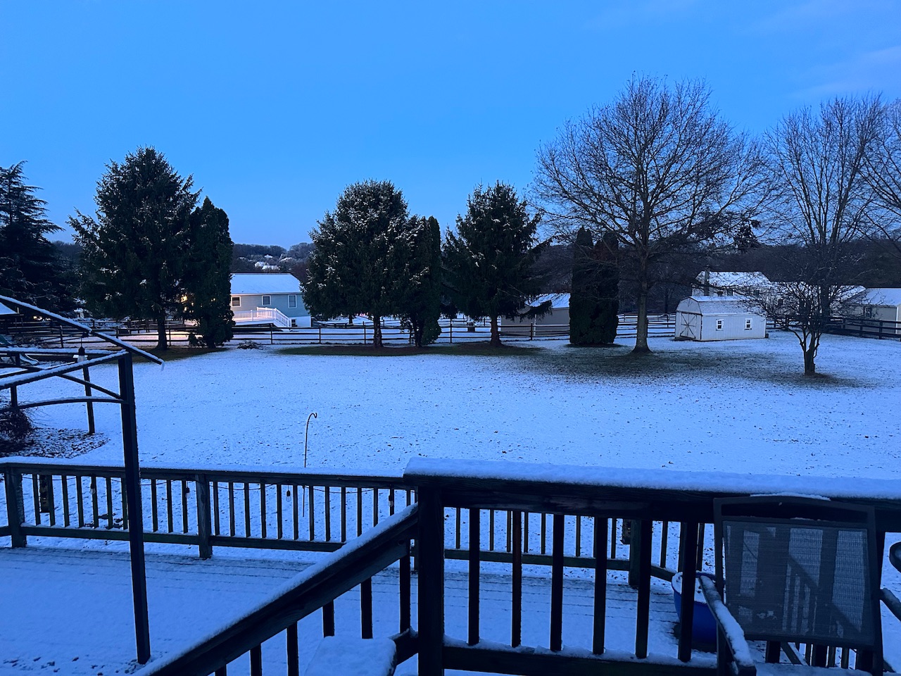
Measured an inch of mashed potatoes. May have been more when it was falling, definitely melting.
Kiddo gets her first 2 hour delay too
-
9
-
-
Winds became more WNW around 7, temp down to 47 from 55 an hour ago. 1.1” rain so far


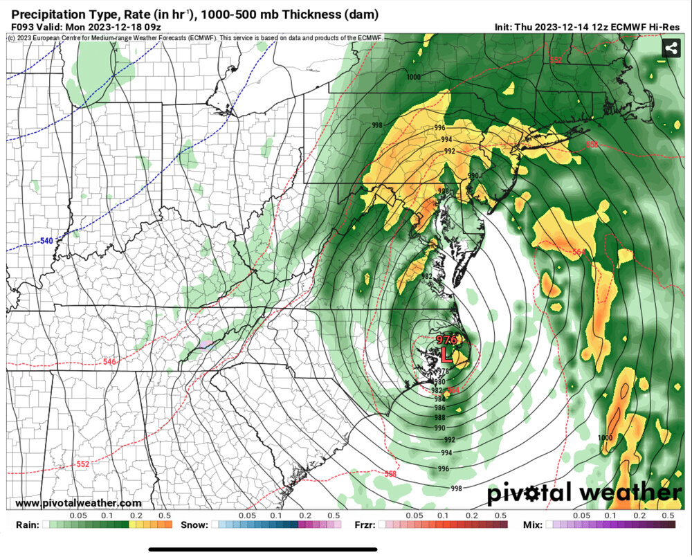
12/17/18 Disco/Obs - Rain/Wind Event
in Mid Atlantic
Posted
damn leaves!