Stormlover74
-
Posts
24,013 -
Joined
-
Last visited
Content Type
Profiles
Blogs
Forums
American Weather
Media Demo
Store
Gallery
Everything posted by Stormlover74
-
 Icon came a bit nw but not really warmer
 -
Tomorrow at 3pm
-
A bit weaker with precip
-
Advisories wouldn't be issued until later... usually inside of 24 hours but yeah they may very well go with a warning for them but not you
-
I expect Upton to go with advisories for Union eastern Essex and everyone else east of the parkway. Not sure about eastern LI. Western Essex probably gets a warning along with bergen and passaic and north of there. Somerset is a tough call for Mt holly as they don't split the county so they could go warning there
-
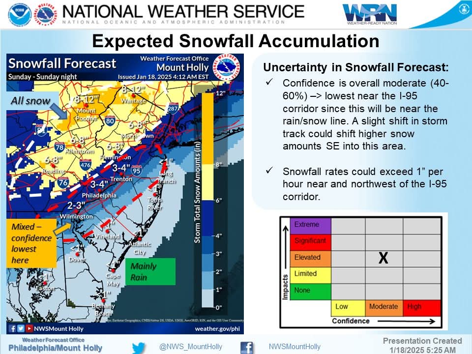
Yeah I'm not sure what to think. The euro gfs and rgem continue to adjust maybe trying to come to a consensus track just offshore. I worry we lose some precip at the onset too with temps above freezing at the start and it's such a fast mover that any delay shaves off accumulations. I like the typical areas like n&w of 287 as a lock for 6+ now. Hopefully everyone at least gets 2 or 3 from the heavy burst in the evening like the gfs has been showing.
-
33-34 at the start. Mid to upper 20s at the end
-
Euro is like 3 or 4 for us but 6+ west. Less east. Eps came way west
-
06z euro came west. It needs to stop
-
So gfs is tucked in a bit at 6z but rgem made a se jog. Still tricky for 95 and the coast
-
Friday
-
Regular nam
-
Watch the rgem go further amped at 0z
-
What else am I going to do between 7 and 9?
-
Right. I only mentioned because it made a pretty sizeable shift but it's still not very useful so it could shift back
-
Doesn't mean much but the 0z hrrr is well southeast of 18z
-
Something's gotta give. Maybe not til 0z tomorrow
-
Gfs is stronger and has heavier precip even though it all falls in about 8 hours
-
So many absolutes for being 48 hours out of things that can or can't happen. Let's remember the gfs had nothing 48 hours ago. The nam nada yesterday
-
3 to 5. Ukie like and cold
-
Yeah its 50 miles east of the 12z rgem
-
Not quite