
Stormlover74
-
Posts
20,407 -
Joined
-
Last visited
Content Type
Profiles
Blogs
Forums
American Weather
Media Demo
Store
Gallery
Posts posted by Stormlover74
-
-
7 minutes ago, paweather said:
and it doesn't transfer it just heads east. This is what you want up in NYC. That is why you see the snow totals.
Well the snow totals are high because the models are assuming anything frozen is a 10:1 ratio. Since 70% looks like sleet or freezing rain accumulations would be nowhere near what the snowmaps show
-
 2
2
-
-
6 minutes ago, RU848789 said:
Is there a map showing the primary in Pittsburgh? Maybe I missed it.
Not quite Pittsburgh but northern WV
-
Just now, USCG RS said:
I still believe that this ends up as more snow for the region than we think. I believe the LP does not make it up to Pittsburgh as shown verbatim, for reasons I've laid it before. Now.. We wait and see.
Sent from my SM-N960U using Tapatalk
50-100 miles further south is probably all it would take to keep us mostly snow
-
2
-
-
Just now, NYCweatherNOW said:
Looks like 10 inches for the city
Much of that is not going to be snow with 850s above freezing for a time
-
1
-
-
Fv3 is much improved as well. Low is south of LI with a lot of ice
-
4 minutes ago, Animal said:
Qpf is not really that impressive on the 0z nam. We will survive.
6 inches of snow or so over a sandwich of sleet & freezing rain.
1-1.5" still pretty high
-
Stays all frozen for everyone just west of the city even with the low over nj
.thumb.png.78d8436f646351984ef5c843b19db3e5.png)
-
13 minutes ago, Ericjcrash said:
NAM is amped. I'm just about done.
Yeah mixes much earlier this run. Front end dump of snow would be a few inches at best
-
21 minutes ago, SnowGoose69 said:
The odd thing though is at this range in 2007 most models showed that event being entirely snow. So either models sucked worse then on thermals or that started more off the coast and trended more NW as we got closer in. I don’t remember.
I think by 72 hours out mixing was starting to show up because of the 850 low being in ohio. Even then we got far less snow than forecast as the change to sleet was fairly quickly
-
6 minutes ago, EastonSN+ said:
Nevermind. Here it is not so bad.

Pretty big drop from 12z actually
-
15 minutes ago, Doorman said:

go to the link and then run the loop...
Keep calm and think for yourself!!!
Nice civil war battle going on the M/D line between snow and fr. rain
-
1
-
-
1 minute ago, friedmators said:
The NAM seems to be pretty fast. 6-8" NW of 95 by 6Z Sunday.
Yeah would be a decent front end thump before warming occurs
.thumb.png.c6f637afcd4e3383db6b6870af2c949c.png)
-
7 minutes ago, CIK62 said:
12Z EURO seems to be all Snow, but only 9" here. This is despite all precip. {2"}coming with temps. from 32-10, then going near 0 after storm departs. Why is this not 20" to 30"? I think you have to have a Skew-T to figure this out by examining the mid-levels. Anyone know if this is available on the internet anywhere?

Have you seen the 850 temps?
-
Just now, NJwx85 said:
What could occur synoptically that would cause the primary to die faster?
I have no idea but we've seen massive changes past 72 hours before. Could still end up a big rainstorm for all we know
-
1
-
-
3 minutes ago, TriPol said:
But with high winds and much of this precip falling quickly, how much ice actually accumulates on exposed power lines and roads? Just because 1.8" of precip falls, doesn't mean it actually accumulates.
Correct you won't see as much ice accretion as you would if the rain was lighter
-
2 minutes ago, NJwx85 said:
Yes I did say that, however the primary low tracks up to at least West Virginia on every piece of guidance.
Sure right now
-
2
-
-
25 minutes ago, NJwx85 said:
It's not happening, period. The WAA will simply not allow it. This has always been a snow to rain vs snow to ice, depending on surface temps.
Pretty sure you said to wait til Thursday before making any definitive statements
-
 3
3
-
-
Can't even imagine if the AFC championship was in New England instead of KC Sunday night
-
Just now, TriPol said:
We've officially hit the blank square stage of storm predicting in the 21st century.
Draw your own solution

-
1
-
-
Just now, Brasiluvsnow said:
Thanks 74 NO LIE that looks good to me,,,,,,but there is still lots of time but really good looks from all the models tonight, all headed the right way
Especially from just 12 hours ago.
-
1
-
-
Got from another forum. I can delete if not allowed. Looks great, even better than ukie for the city and coast

-
1
-
-
Just now, Brasiluvsnow said:
74 how much outside the city,,can u post snow map ?

-
1
-
 1
1
-
-
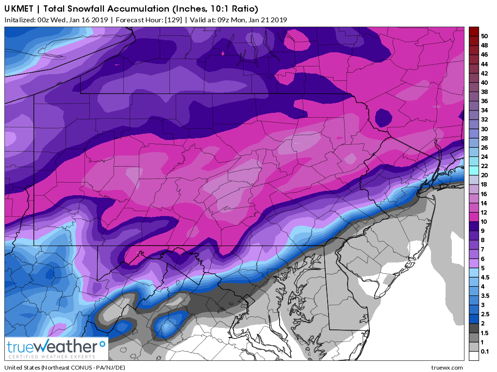
Ukie snow map isn't really that great. 2-5" with a change to sleet and freezing rain for the city and coast
-
4 minutes ago, Ericjcrash said:
Lock it up.
Don't like the west tick but considering where we were 3 hours ago we can't get Greedy. Need the PV to squash this.
Is it west or just slower? It was in GA now AL but as long as it goes offshore to the BM we should be fine
-
1
-
.png.759d1b8b636454f06402c9e001391063.png)
.png.b64415c41289f84e617aa19c9bd67d81.png)

January 19-20th Winter Storm Threat
in New York City Metro
Posted
wow a foot of sleet