mgerb
-
Posts
323 -
Joined
-
Last visited
Content Type
Profiles
Blogs
Forums
American Weather
Media Demo
Store
Gallery
Everything posted by mgerb
-
@RU848789 Not yet; haven't had the chance. I'll try to chime in this weekend!
-
Something to consider from the MA thread, which makes sense. In other words, somewhat small changes upstream can really make a difference (in either way, of course).
-
Yup, saw that's how what you do. That's not how it's done in CoCoRaHS and COOP, so I don't really agree with this article. Rather, the maximum accumulation over the prior day of all snow/sleet is what is reported each day. That said, passing this along to some "snow experts" to see if they've ever heard of this practice.
-
I also don't clear the board except for ob time. If I cleared the board at transition, would obviously have more, but that's not really kosher (at least for CoCoRaHS).
-
I had 7.6" around the time of transition, and every time I went back out to measure each hour, it remained at 7.6". So there was enough compaction to counter any sleet accum. Haven't been out since 4 PM though, so will check again at 7:00. Hopefully have resumed a bit of accumulation since then, rather than only making the existing back denser (but not deeper).
-
Snow/sleet mix now. But still plenty of flakes.
-
When I checked at 12, I had 0.64" (based on weight). Definitely a tough event to get an accurate SWE.
-
Kickass. Keep it coming. Can't believe it's still 11 deg (edit: now 12 deg).
-
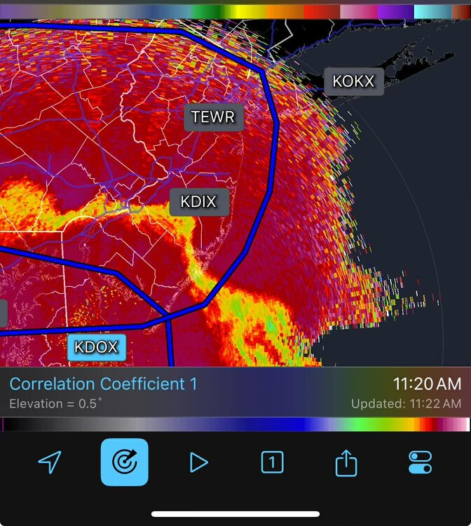
What's your mix? Some snow, some sleet? Oddly, there's little signal on KDIX base reflectivity (or the other tilts), but KDOX shows it well.
-
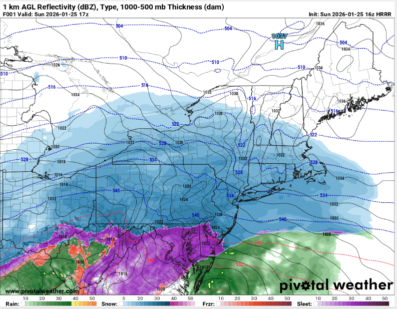
FWIW, HRRR hr 1 (12 PM) is too far south with the sleet line, as it appears to be approaching southern Mercer/Middlesex in NJ (based on CC and mPING). Around 7" so far here, so might be able to pull off low-end double digits with sleet included. But also suspect there will be some compaction with the sleet on top.
-
Snow/sleet line is further north than this indicates. KDOX shows it well.
-
OK, yeah. That was pretty unequivocal
-
He's a met. Also, someone claimed he said that. Should probably get a quote about exactly what he did or didn't say. It might not have been so cut and dry (or maybe it was!).
-
14.6" on the season just over the river in Somerset. 5" OTG this morning, with 5.7" in total over the past 2 days. I'll be working on compiling NJ snow totals for these two separate events that we'll post here: http://climate.rutgers.edu/stateclim/?section=menu&target=wint2526snowtotals Since the 1/18 event started before most morning ob times in 1/18, it will take some effort to split out the 1/17 and 1/18 snowfalls.
-
https://www.ncei.noaa.gov/access/monitoring/rsi/nesis
-
Not as applicable to our latitude, but saw Buffalo gusted to 79 mph (though I see 75 mph, so not sure if the 79 is legit).
-
FWIW, FV3 looks good (run not complete here)
-
6.2" in Somerset (but well over 7" if measuring in grass, which is why it's important to use a board!). Might pick up a few more tenths before it tapers.
-

Moderate snowfall 12/14/2025 WWA up for most of the area
mgerb replied to WeatherGeek2025's topic in New York City Metro
Using our new Franklin station? Literally just finished installing yesterday. https://www.njweather.org/station/3678 -
Jeff Berardelli is who he meant. E.g., https://www.facebook.com/JeffBerardelli/
-
Do you report to the program?
-
There's definitely a subjective aspect to it, and one author may interpret the slew of objective data sets slightly differently than another. Aside from precip, ground water, river flow, a range of drought indices, and reports from the ground are all used to compile the product. In terms of how it's made, you might check out this short video (first below) and then a much longer and presumably much more detailed video below that (second). I think they'll be instructive in explaining how it all comes together.
-
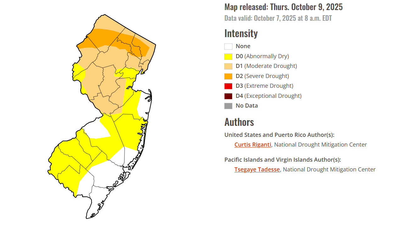
I can't reveal too much, as the final decisions lie with the national author. But from the state climate office side, we suggested mostly status quo (no change) this week, aside from removing some lingering D0 in eastern Ocean (warranted with the heavy rain from the nor'eater). They also eased up a bit in Bergen and eastern Passaic, which is fine too given the 1.50"-2.00" rainfall there, as we were on the fence about recommending improvement there or waiting. As for the areas of degradation in the western parts of the state, it's really just slight expansions of existing D0 (in Burlington) and D2 (in the far northwest), which we didn't explicitly suggest, but have no problem with given the continued dry conditions and relatively low totals from the weekend storm. Very minor changes overall. If you haven't yet, I'd recommend checking out the comparison slider, as it nicely shows the specific category changes from last week to this week. You can zoom into NJ: https://droughtmonitor.unl.edu/Maps/ComparisonSlider.aspx
-
Some of us definitely do.

-
0.41" in Somerset (0.53" including Saturday's rain). The cutoff is quite extreme, but this aspect of the event was (eventually) modeled well. Was hoping it might just push a tad further west. Better than nothing though! The drought continues.
- 731 replies
-
- 5
-

-

-
- heavy rain
- damaging wind
- (and 2 more)