

Yeoman
-
Posts
3,204 -
Joined
Content Type
Profiles
Blogs
Forums
American Weather
Media Demo
Store
Gallery
Posts posted by Yeoman
-
-
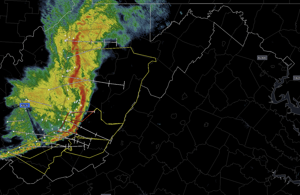
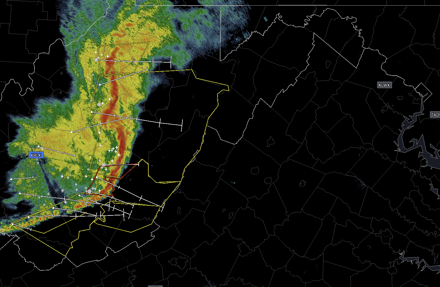
Pretty impressive line and moving quick..
 1 hour ago, EastCoast NPZ said:
And meanwhile in Stephens City....not a drop.
No one cares
-
 1
1
-
 2
2
-
-
9 minutes ago, Ji said:
i dont think this one is changing. In fact, the signal is getting better as we get closer. Kind of the opposite of February
ahh you're right.. 14 days out is the sweet spot for model accuracy
-
1
-
4
-
-
59 minutes ago, Eskimo Joe said:
WHERE.WAS.THAT.RIDGE.ALL.WINTER?!

10-15 days out at least 12 times a week.. so no different from the fantasy map he posted, which of course will change completely within 24 hours.
-
4
-
-
Beyond two or three days, even the world's best forecasts are still speculative, and beyond a week, they are worthless. Such is the paradox that is chaos.
If you have control issues, weather might not be the best hobby for you.
-
1
-
-
2 hours ago, Scarlet Pimpernel said:
But sadly, this is the bullshit reality we live in, and one feels helpless to do much about it when those in power and who have influence on policy, sit there and piss into the wind. Whatever. Sorry if I got too political there, but it's more than that. Fact is, all too many people can be so damned selfish and have no concern or care for how their decisions or policies may affect the world around them. Apologies...done with that rant.
Vote them out? Or just complain?
-
5 hours ago, cbmclean said:
I agree that we probably place too much confidence in modeling in d10+.
Only if you're a complete imbecile.
Read up on the butterfly effect, chaos theory, etc.. Weather will always be largely unpredictable until we figure out a way to control it.
-
2 hours ago, EastCoast NPZ said:
That's it. I just sold my snow thrower. Used once since the 2016 storm (and that was at my old place in cross junction). Oil drained and replaced yearly, paid to move twice...all just to sit in my garage and collect dust. Literally looks as good as the day I bought it. It would've never gotten used again in stephens city, unless maybe to cleanup future sandstorms.
Cool story.. hopefully your crops are doing better
-
2 minutes ago, J.Mike said:
Serious question: is Ji ok?
He's covering Creed at the McLean Bible Church this morning.
-
1 minute ago, EHoffman said:
I don't even care about accums now, if I don't see thundersnow this storm is a bust
In DC I wouldn't either... it will likely be history if you wake up after 9am.
-
14 minutes ago, Terpeast said:
I’m starting to prefer that. When we lose school days, the kiddo stays home and the only time she’s in a happy mood is when we’re playing outside in the snow. But if we’re not outside, it’s tantrum galore. Rather send her to preschool and keep the snow on weekends when she’s home anyway.
That’ll change when she hits kindergarten or first grade, but for now… yeah.
She's probably just angry you call her "kiddo"
-
3
-
-
24 minutes ago, snowmagnet said:
I don’t understand why the national weather service didn’t give us at least a hazardous outlook warning for slick roads.
Maybe they assume people have common sense
-
1
-
-
At least we're putting a dent in the drought
-
1 hour ago, Shad said:
thoughts on hour 240 of Euro?
It's hour 240
-
1
-
 1
1
-
 1
1
-
-
30 minutes ago, Scarlet Pimpernel said:
The complaints about "too warm leading in!" for the potential PD-3 event around here are ridiculous. First, it's 200+ hours out! Second (if you really want to get into the details!), the temperatures literally crash as the storm begins and it remains quite cold for a couple of days after. The same temperature depiction was shown for 00Z and 06Z, when everyone was ga-ga over this. Again, it's 200+ hours out, but the overall hints for this general time period have been discussed at length.
And your comment about cold smoke in March...spot on! The one I remember best was March 5, 2015. That featured a front that went through early in the morning followed by rapid cooling, as a wave moved up the front and gave us that storm. In fact, I recall @Deck Pic (I think it was him?) very early that morning saying watch how many people freak out because it wouldn't be snowing yet when they woke up, when the event wouldn't really start until mid-morning. And sure enough, people freaked out because it was still wet but no snow falling...even as the damned storm was right on our doorstep (and it began snowing shortly after)!
I think that was actually Zwyts.. regardless, a tremendous call, indeed!
-
1
-
1
-
-
43 minutes ago, TSG said:
Okay I went back and read... going to disagree pretty strongly with this entire statement. If you thought Feb 5/6 wasn't a long shot when we saw it pop up around the 25th, you weren't paying attention close enough. Numerous posts about how it would be nice to score during our "lull" that week. Here's a few from around then...

And what do we see on the 11/12th and beyond the last few GFS runs? Cold air being reestablished with shortwaves sliding across to our south.
If the can has been kicked it's like 2 days
I guess low 50s is considered cold these days..
-
1
-
-
5 hours ago, Weather Will said:
Positive news for WB 6Z GEFS, cold air gets reestablished President's weekend.

Nice.. 49 degrees instead of 52
-
2
-
1
-
-
1 hour ago, NorthArlington101 said:
This is why we lose people. We’re looking 3 weeks ahead (fine… 2.5) and have been tracking epic patterns for weeks.
I think it’s actually a credit to modeling that I’m starting to go insane. We’ve seen this look for so long you’d swear up and down it’s been 15 days away for a month. And it’s still 15 days away.The sooner you realize models are clueless beyond a few days the less you'll pay attention to that nonsense and maintain your sanity..
-
2 hours ago, WEATHER53 said:
Is mid Feb (10th to 19th) still on or delayed to 20th to 29th?
Now looking like the 30th
-
2
-
6
-
-
13 minutes ago, thunderbolt said:
No the week of the 14th
Only if Phil sees his shadow on Friday
-
2
-
-
21 minutes ago, thunderbolt said:
I guess you’re not liking this time period Coming up
The epic pattern that was supposed to start next week?
-
5
-
-
37 minutes ago, aldie 22 said:
What happened did you get laid off or something?
Not yet.. you'll know I've been laid off when I start posting as much as Ji
-
1
-
-
1 minute ago, stormy said:
I received 9 inches on April 7, 1971 at 1300 ft. !!!!! At 1850 ft, April 7, 1971 received 17 inches...
Must have been flying Air Randy
-
6 minutes ago, Kevin Reilly said:
I love it Pineapple Express??? How is this a Pineapple Express when the flow is not coming from Hawaii. Look at the Water Vapor Map. This "Pineapple Express" is used for one thing especially in this case Ratings!!
Pennsylvania Water Vapor Satellite Weather Map | AccuWeather
He meant the jet extension
-
1
-
-
1 hour ago, Ji said:
pretty scary thought---because if we dont see a big snow or two......this hobby is pretty much done
Time to dust off the crochet kit
-
2
-


April Discobs 2024
in Mid Atlantic
Posted
That's tough.. nothing more exciting than steady drizzle.
Hopefully you're still able to feed your family