

ShawnEastTN
-
Posts
1,881 -
Joined
-
Last visited
Content Type
Profiles
Blogs
Forums
American Weather
Media Demo
Store
Gallery
Posts posted by ShawnEastTN
-
-
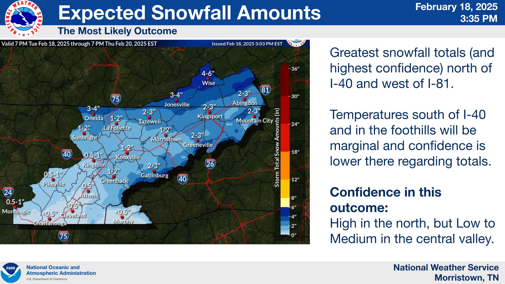
Sitting right at 2" when forecast by MRX .5 to 1". Still snowing.
-
 3
3
-
 1
1
-
-
Imby I bottomed out at 32 degrees at 9:24 pm then began warming from then till about an hour ago. About an hour ago I topped back out at 36 since then temp is falling again I believe in response to moisture in the dry air as my temp has fallen back to 33 and it's falling a tenth a degree or so every 5 minutes. Dew point is fluctuating back and forth at 25 & 26.
-
1
-
-
35/26 for me 67% humidity.
-
1
-
-
Radar starting to fill in quickly between Nashville and Crossville. I know there will be a period of virga but think it'll start sooner than forecast. Might need to move start times that MRX forecast an hour or more earlier. Virga already over me in the Great valley.
-
3
-
-
9 minutes ago, Wurbus said:
Don't look at the 9pm plumes for Knoxville. Mean cut in half to .2 qpf
Yikes!!!
-
Looks like it is getting some GOM hookup to me.Hope the GOM gets in the game soon or the Euro might be right.


-
1
-
-
3 minutes ago, nrgjeff said:
I like the models that bring snow into Chatty. Not a wish-cast, just makes sense with cold enough temperature profile and partial thickness. Surface could get up to 38 but that no problem, all else in place.
Now, the lee of the mountains. That's some cruel and unusual punishment - twice counting Jan. 10! Some high-res models agree with the snow shadow early. Then perhaps some NWFS will save last-minute.
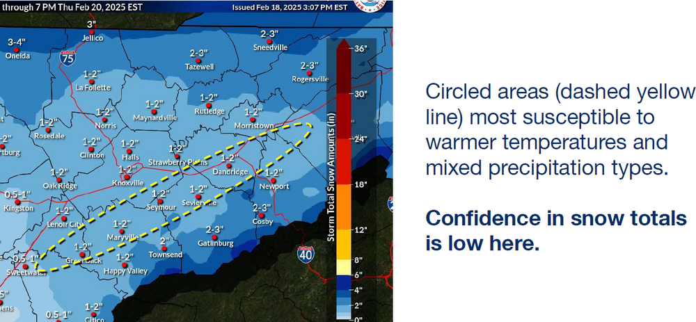
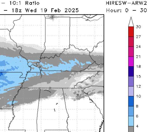
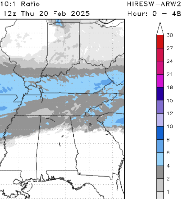
That model depiction of ARW2 looks to me what makes the most sense for most of the valley of East Tennessee. I could buy 2-4" for most of the East Tennessee valley.
-
2
-
1
-
 1
1
-
-
15 minutes ago, John1122 said:
I'm sure it's whatever the latest NBM is. They basically seem to never use anything but it. It's pretty much an ensemble mean it seems.
YES!!! It seems they always go NMB hardcore. It also seems NMB is often weighted in weird ways that seem to be way more conservative than actual verification. Great example was the deep south snow and our January snow. Both they seemed to align with NMB and in both cases it was way more conservative than actual verification.
-
3
-
-
4 minutes ago, PowellVolz said:

Slight increase for most from their last map.
-
2
-
-
8 minutes ago, John1122 said:
The HRRR has a stubborn surface warmnose up the Eastern Valley. It basically runs along 40. South Knox is 33, north Knox 30ish.
This is what I wonder if models are over doing downsloping and warm nose in combination with each other for a sort of double wammy for the East Tennessee Valley. Most modeling I've seen the push of warm air both warm nose and downsloping look a bit over done to me for this storm strength and track honestly I'm more worried about CAA and virga. Then you have models like the graf that have essentially been saying what warming of either type? Though I don't really know anything about the graf. Going to be an interesting morning tomorrow maybe some big busts in either direction.
-
2
-
-
If it means anything at all my point forecast has zero rain or mixing in now. All snow, and actual snow, not snow showers. Where yesterday and this morning included the weird snow then rain then snow again verbiage they often use. Also just reading MRX afternoon discussion which just came out about 15 minutes ago they mentioned advisory criteria area wide so they may pull the trigger on southern valley which would be smart considering Chattanooga has morning traffic too and schools and such and if they are "uncertain" as they mention over and over the wise thing to do is air on the side of caution.
-
5
-
-
Same here if the direction is more westerly I can actually get flow snow. WNW works for me but NW doesn't I think because with NW I'm in the shadow of Hinch Mountain the highest point in Cumberland County, I am due SE of it by about 10 miles. If the flow is more westerly that shadow shifts north of me just enough. Even NNW I tend to get some flow snow but not as good as WNW.Really hoping the mods are over doing the downsloping into the valley. It would really help me if the flow was more W to E. That would give my area a little more time to allow lift to kick back in. NW to SE is a killer for my area.
Something really feels off to me about this storm. Start time for most will be during the coldest part of the day, my ground has been frozen the last few mornings and shaded areas have remained frozen solid even during the day. Last night I was forecast low of 29 but got to 25. Something just feels off about MRX forecast feels almost too cautious. At least for my area which is northern edge of the southern valley. My area also Sweetwater and Madisonville even Athens don't always fit "southern valley" forecasts like Chatty and Cleveland for instance.
-
2
-
-
Didn't the Euro have the system in January pretty anemic until just before go time? Am I remembering that wrong? Seems it was on the lower end of qpf and then started bumping QPF run after run up until go time. Maybe I'm mixing it up in my head with another storm. Though it was similar if I remember where GFS was more juiced and Euro less and the euro basically came around towards the GFS.
-
2
-
-
GFS is really sticking to its guns keeping the snow/rain line down just south of the Tennessee border. Hopefully it's sniffing out the CAA better and warm nose less of an issue.Watching this baby trend south again on the 18z GFS, that makes me happy to be on the Southside of this system for once.-
5
-
-
Wondering if I can rival last year's -1 temp over the next couple mornings. Probably not as last year when that occurred I had 10" of snowpack. This year nada.
-
1
-
-
Got down to 8 and slowly climbing now up to 10.
-
Ok maybe mother nature is trying to prove something, first time today I've stepped up above flurries to an honest to goodness snow shower. Maybe there is hope yet imby.
-
3
-
-
23 minutes ago, nrgjeff said:
Guess what's happening in Chattanooga. Cloudy, windy, and cold. Nothing more than a few snow grains.
Same here, downslope by the plateau. Cold windy with a few dry flakes here and there. For me the trajectory needs to be more NNW to see anything, not really sure why that works but regular NW doesn't.
-
1
-
-
I also still have some large areas of snow that survived the rain on my property. If lucky might beat last year when snow survived 16 days.
-
4
-
 1
1
-
-
23 minutes ago, dwagner88 said:
That actually makes sense to me. The amplitude between warm moist airmasses and cold dry ones is at its peak in the shoulder seasons.
Same reason why our best chances for a winter storm regardless of month is the beginning or ending of a cold blast. The transitions have the moisture.
-
2
-
1
-
-
4 hours ago, Uncle Nasty said:
Before I fell asleep last night, I was reading an article from a met based in Missouri. He used to be based in Charlotte. I'll look for the link later on my lunch break. He says as suppressed as the midweek storm looks, don't be surprised if that push of Arctic air modifies quite a bit compared to what is depicted currently on models. If that happens, more qpf could make its way as far north as the Kentucky line, and possibly drop anywhere from. 25-.40" of qpf for parts of Tennessee. With a high ratio snow, that would quickly accumulate for several forum members. I'm not wishcasting, just repeating what a met mentioned. A late model shift and I guess anything is possible.
This is a hope I've been clinging to. A good example was the most recent cold which wasn't as extreme as originally modeled. That scenario the Met describes makes sense if the cold isn't as strong as modeled, and I hold on to hope that the late week storm that the GFS advertises is a perfect track storm that we at least get if we don't get the over running.
-
2
-
-
Looks like GFS is doing both over running event for beach towns and winding up a storm as a cutter to wrap up this cold shot before it likely reinforces another cold shot after the cutter. Could have redeemed itself and given us a good miller with a good track to round it out instead of a cutter if we aren't getting the over running.
-
Now to see what it does end of week, if anything.
-
GFS might finally be coming around to the deep south event and away from Millers or cutters. It at least has some heavy snow for Gulf beaches, and a low centered on the Yucatan Peninsula. Lol. Only out to 0z Wednesday. That run only beach towns get snow no one more than 50ish miles inland get anything.

2/19-2/20 Miller A Magic?
in Tennessee Valley
Posted
There is a ton of low level moisture out there. This might be a good event tonight if the lift is decent. I've been getting snow all day, mostly little flurries since about 10am but still loads of low level moisture.