Regan
-
Posts
577 -
Joined
-
Last visited
Content Type
Profiles
Blogs
Forums
American Weather
Media Demo
Store
Gallery
Everything posted by Regan
-

The “I bring the mojo” Jan 30-Feb 1 potential winter storm
Regan replied to lilj4425's topic in Southeastern States
What are your expectations at this point? I lowered mine a long time ago. Give it time. It’s 3:30 -
The “I bring the mojo” Jan 30-Feb 1 potential winter storm
Regan replied to lilj4425's topic in Southeastern States
They said it’s slowly moving east and we have hours to go. -
The “I bring the mojo” Jan 30-Feb 1 potential winter storm
Regan replied to lilj4425's topic in Southeastern States
They literally just said wake has hours left… you complain it’s not started and then when it’s started (before it can really get going) you start with the doom. 1-3in whatever oh brother. -
The “I bring the mojo” Jan 30-Feb 1 potential winter storm
Regan replied to lilj4425's topic in Southeastern States
Some of these radar are wonky with future casts so I’d be hesitant. Wrals and weather bugs from experience is bad. Wral doesn’t even have it moving in the right direction as the storm is moving. -
The “I bring the mojo” Jan 30-Feb 1 potential winter storm
Regan replied to lilj4425's topic in Southeastern States
So did everyone else when it started. -
The “I bring the mojo” Jan 30-Feb 1 potential winter storm
Regan replied to lilj4425's topic in Southeastern States
You sound like packgrad lol -
The “I bring the mojo” Jan 30-Feb 1 potential winter storm
Regan replied to lilj4425's topic in Southeastern States

-
The “I bring the mojo” Jan 30-Feb 1 potential winter storm
Regan replied to lilj4425's topic in Southeastern States
Uhhh. I can’t tell if you’re kidding. My senses are shot. -
The “I bring the mojo” Jan 30-Feb 1 potential winter storm
Regan replied to lilj4425's topic in Southeastern States
Sorry. No more hi res. Hi res can equal hi problems. -
The “I bring the mojo” Jan 30-Feb 1 potential winter storm
Regan replied to lilj4425's topic in Southeastern States
I will be thrilled at this point with 3in. Happy with 2. WRAL keeps saying Wake be patient because it’s coming and it’s not over til late. it’s about changing your expectations. We just need to get it here. -
The “I bring the mojo” Jan 30-Feb 1 potential winter storm
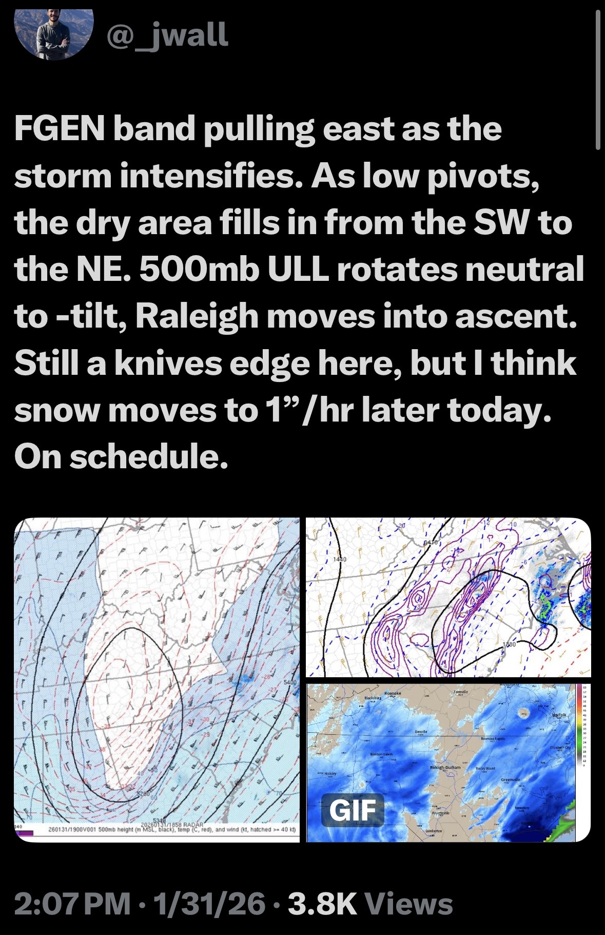
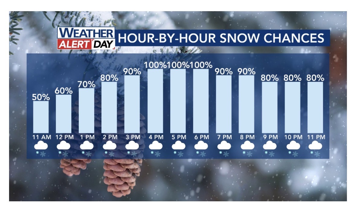
Regan replied to lilj4425's topic in Southeastern States
Based on this chart…I mean… the Dr could be right. It’s not “over”? is there any positivity? Do you really think there will be a gap the ENTIRE time? WRAL is scared to say, but now and then show their futurecast filling in.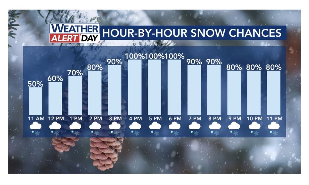

-
The “I bring the mojo” Jan 30-Feb 1 potential winter storm
Regan replied to lilj4425's topic in Southeastern States
Eh?
-
The “I bring the mojo” Jan 30-Feb 1 potential winter storm
Regan replied to lilj4425's topic in Southeastern States
But where in Raleigh? -
The “I bring the mojo” Jan 30-Feb 1 potential winter storm
Regan replied to lilj4425's topic in Southeastern States
I know you can’t be exact but if let’s say, we did… looks like I can get in on the higher numbers to the west part of wake. Derp -
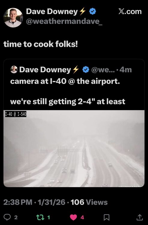
January 30th- Feb 1st ULL and coastal storm obs
Regan replied to JoshM's topic in Southeastern States
21 an still nothing near rdu airport. Hoping to get some later today. Hrrr and Nam says so -
The “I bring the mojo” Jan 30-Feb 1 potential winter storm
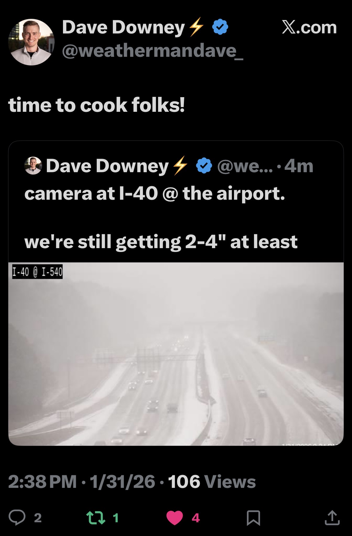
Regan replied to lilj4425's topic in Southeastern States
It’s not the 3k, but Allan just posted this 12k saying it offers hope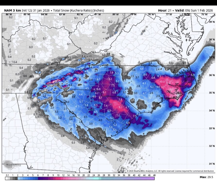
-
The “I bring the mojo” Jan 30-Feb 1 potential winter storm
Regan replied to lilj4425's topic in Southeastern States
Allan tweeted that there’s hope for make if you look at the Nam. Later today and int tonight. -
The “I bring the mojo” Jan 30-Feb 1 potential winter storm
Regan replied to lilj4425's topic in Southeastern States
https://www.facebook.com/share/18JUgpSTBJ/?mibextid=wwXIfr Fishel’s update. Sticking his guns. Says why. I mean… ok. Still. I’d love to see something fall. -
The “I bring the mojo” Jan 30-Feb 1 potential winter storm
Regan replied to lilj4425's topic in Southeastern States
When to expect? -
The “I bring the mojo” Jan 30-Feb 1 potential winter storm
Regan replied to lilj4425's topic in Southeastern States
This is always a possibility. Nobody knows anything concrete now. Modeling sucked. It snowed in many place way before it was supposed to. I feel like forecasting has been a grasp and that mets are just following suit. One says it, they all say it. Dry slot is the new buzzword. Like hanging chad back in the day. -
The “I bring the mojo” Jan 30-Feb 1 potential winter storm
Regan replied to lilj4425's topic in Southeastern States
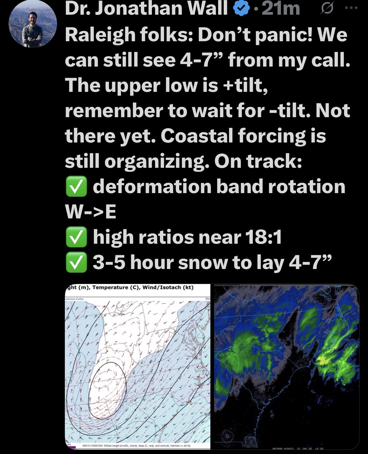
@eyewallStill not awful. Raleigh is 5 (4-8) and my zip had 3-7 total possible. id like to see 3 at least. -
January 30th- Feb 1st ULL and coastal storm obs
Regan replied to JoshM's topic in Southeastern States
24 near edu airport. Swear I saw some “dust” sized scattering in the wind. Handy flashlight helps. Also that wind hurts. -
January 30th- Feb 1st ULL and coastal storm obs
Regan replied to JoshM's topic in Southeastern States
24 near RDU airport. Nada. -
The “I bring the mojo” Jan 30-Feb 1 potential winter storm
Regan replied to lilj4425's topic in Southeastern States
24 here -
The “I bring the mojo” Jan 30-Feb 1 potential winter storm
Regan replied to lilj4425's topic in Southeastern States
Seriously. I was just up checking the temps. Still no teen. Don’t want to drip if we don’t have to. So, I peaked at the updates.