high risk
-
Posts
3,280 -
Joined
-
Last visited
Content Type
Profiles
Blogs
Forums
American Weather
Media Demo
Store
Gallery
Everything posted by high risk
-

2020 Mid-Atlantic Severe Weather - General Thread
high risk replied to Kmlwx's topic in Mid Atlantic
Soundings for Wednesday definitely look great. Shoutout to Kmlwx for noting this threat way in advance. While the dynamics as currently progged aren't great, a nearby front and small height falls could be enough. If we can trigger storms, the setup for SVR will be pretty robust. -
2020 Mid-Atlantic Severe Weather - General Thread
high risk replied to Kmlwx's topic in Mid Atlantic
nice work, everyone! I remember that event quite well. I was warning people at work not to be on the roads at rush hour. That alert didn't work out too well...... -
2020 Mid-Atlantic Severe Weather - General Thread
high risk replied to Kmlwx's topic in Mid Atlantic
The EML is definitely essential here if we want a wind system to survive its trip over the mountains. In 2000, a bow echo was racing east towards us, and SPC put out the rare PDS severe thunderstorm watch, and it completely crapped out trying to cross the mountains of West Virginia and Virginia. We ended up with showers that gusted to 30 kt. -
2020 Mid-Atlantic Severe Weather - General Thread
high risk replied to Kmlwx's topic in Mid Atlantic
Blue box issued. Montgomery and Howard are in the far southeastern corner, consistent with the idea that this first show will mainly be a fair distance northwest of the I-95 corridor. -
2020 Mid-Atlantic Severe Weather - General Thread
high risk replied to Kmlwx's topic in Mid Atlantic
I'd say overall that southern PA has a slightly higher threat for SVR than the DC area, with a clear CAM consensus for a batch of storms to develop by mid afternoon over far eastern WV and northwest MD and track northeast towards the York and Harrisburg area. -
2020 Mid-Atlantic Severe Weather - General Thread
high risk replied to Kmlwx's topic in Mid Atlantic
https://www.spc.ncep.noaa.gov/exper/href/ (under forecast tools) and if you want information on the upcoming HREFv3 upgrade: https://www.emc.ncep.noaa.gov/users/meg/hrefv3/ -
2020 Mid-Atlantic Severe Weather - General Thread
high risk replied to Kmlwx's topic in Mid Atlantic
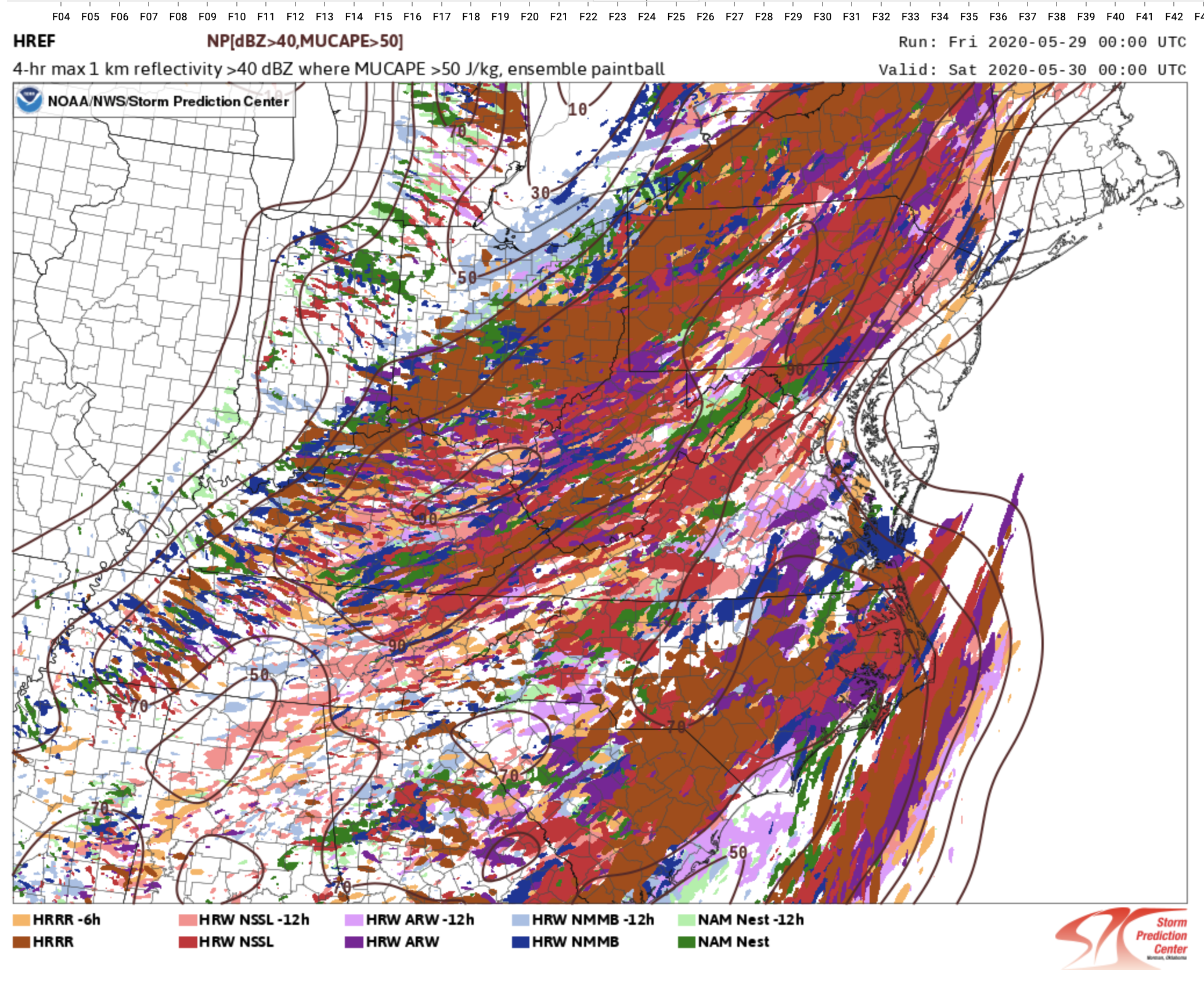
Still unsure whether storms will make it into the DC metro area. There is a better signal for storms moving northeast through northern MD, but anything in DC metro may be an iffy late evening show. It's reflected in last night's HREF members showing 40 dbz which show a clear minimum of members showing storms for DC and points east between 4 and 8pm. (Yes, the 6z NAM came in with a better solution, as shown in the previous post).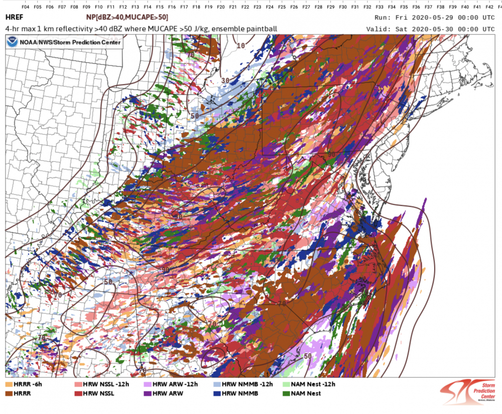
-
2020 Mid-Atlantic Severe Weather - General Thread
high risk replied to Kmlwx's topic in Mid Atlantic
The outlook is pretty legit, but as Amped noted above, the timing now definitely favors those west of the a line from Fredericksburg to Frederick. I'm not really seeing the tornado potential in the forecasted wind profiles, but there is definitely enough deep layer shear (accompanying the modest instability) for SVR. -
2020 Mid-Atlantic Severe Weather - General Thread
high risk replied to Kmlwx's topic in Mid Atlantic
The 12z HRRR shows this scenario. It has low-topped convection moving from south to north, in an environment with some instability and good low-level directional shear. The HRRR is more favorable than other CAMs in terms of instability and shear (which is why its reflectivity looks better than most other solutions), so it may be considered a bit of an outlier for now, but it's within the range of possible outcomes. -
2020 Mid-Atlantic Severe Weather - General Thread
high risk replied to Kmlwx's topic in Mid Atlantic
That would still be the best SVR day we've had all month, and it ain't even close. -
2020 Mid-Atlantic Severe Weather - General Thread
high risk replied to Kmlwx's topic in Mid Atlantic
Fire up the thread - we have a day 3 MRGL!!!! It's remarkable in May that we've gone two weeks without even the need for a wishcast, and Friday doesn't look all that impressive, but we take what we're given. There are big timing differences with the front, and instability is not all that exciting, but if we can get storm initiation later Friday, deep layer shear appears to be sufficient for a few cells to reach severe limits. -
2020 Mid-Atlantic Severe Weather - General Thread
high risk replied to Kmlwx's topic in Mid Atlantic
The SPC outlook discussion is spot on. Forcing is strong, but the soundings look very meh. Best chance of severe will definitely be further south (as suggested by EJ), where temps will be warmer, giving some hope of modest cape, but it's pretty iffy there too. For those north of DC like me, I'll be happy with thunder: NAM nest looks great for that, but it's a bit of an outlier, with several other CAMS not showing good reflectivity signals north of 66 (VA) and 50 (MD). -
2020 Mid-Atlantic Severe Weather - General Thread
high risk replied to Kmlwx's topic in Mid Atlantic
Indeed! check out the 12z NAM nest for Sunday afternoon. -
2020 Mid-Atlantic Severe Weather - General Thread
high risk replied to Kmlwx's topic in Mid Atlantic
While it looks like we'll hopefully avoid some of the nastier scenarios being depicted by various guidance in recent days, I don't think it's worthy of a 'meh' either. We'll still have a 60+ knot low level jet, some very strong lift from multiple sources including upper difluence, and impressive PW values, and even hi-res guidance can often underdo precip in these events. And while it looks to be fairly progressive, there are still some hints of a "round 2" Thursday afternoon in the HRRR and ARW2. Certainly the best chances for big amounts are east of DC, but the chances of really huge totals seem lower now, they're not zero, and we'll still have to deal with issues associated with a heavy event in a short period of time at a minimum. -
2020 Mid-Atlantic Severe Weather - General Thread
high risk replied to Kmlwx's topic in Mid Atlantic
Yeah, wind profiles look awesome to our west Wednesday night, but instability is negligible. On Thursday, the wind profiles along the I-95 corridor will be decent, but instability again looks to be effectively nada. Agree with EJ that any threat would be flooding. It had been looking like the axis of heavy rain Thursday afternoon would set up just to our east, but the 12z NAM is slower, and a heavy rain threat may set up for DC and points east. -
2020 Mid-Atlantic Severe Weather - General Thread
high risk replied to Kmlwx's topic in Mid Atlantic
very reasonable MD issued. a respectable 65/45 at BWI. heating is good - just need to maintain low to mid 40s dew points. It has mixed out to 41 at IAD, but the models have consistently shown a less favorable environment on the west side of DC. -
2020 Mid-Atlantic Severe Weather - General Thread
high risk replied to Kmlwx's topic in Mid Atlantic
Yeah, that area is going to have trouble with dew points due to downsloping. Upper 40s here. T/Td will be fun to monitor over the next 3 hours. -
2020 Mid-Atlantic Severe Weather - General Thread
high risk replied to Kmlwx's topic in Mid Atlantic
I'm slightly more bullish about this than you due to the impressive dynamics, but the better solutions say that we're roughly 64/48 just ahead of the storms. If we don't get there, it will definitely be lame. -
2020 Mid-Atlantic Severe Weather - General Thread
high risk replied to Kmlwx's topic in Mid Atlantic
cape was going to be limited no matter what, but yeah, we need every degree we can get today. At least warm advection is at least somewhat offsetting the lack of sun -
2020 Mid-Atlantic Severe Weather - General Thread
high risk replied to Kmlwx's topic in Mid Atlantic
yes. The soundings are really cape-starved. The only reason we have a chance is because the dynamics of this system are really impressive. Hail is a concern due to the low freezing levels for sure, but the meager instability argues against seeing widespread larger sizes. -
2020 Mid-Atlantic Severe Weather - General Thread
high risk replied to Kmlwx's topic in Mid Atlantic
no real change in the 12z guidance. While they differ on coverage/intensity/timing, all CAMs have some amount of convection in our area early to mid afternoon tomorrow. The best signals for coverage and intensity are areas well northeast of here, and the signal within our area is better on the east side of town than on the west. Sfc-based cape isn't great, but there is some in all progs. Soundings support some stronger wind gusts, and I agree with SPC that due to the very cold air aloft and low freezing levels, some hail is possible in any stronger, discrete cells. The MRGL seems to cover the threat well for now. -
2020 Mid-Atlantic Severe Weather - General Thread
high risk replied to Kmlwx's topic in Mid Atlantic
Slight improvement for Tuesday in the 00z suite. Best chances still appear to be for those further northeast, but both instability and simulated reflectivity improved a bit. Will be tougher to get decent convection the further west you are due to downscoping. -
2020 Mid-Atlantic Severe Weather - General Thread
high risk replied to Kmlwx's topic in Mid Atlantic
Was just coming in here to post this, but you beat me to it. The forecast soundings look better to our northeast (in the MRGL area) due to it being colder aloft, but there might be a small amount of instability in areas along and east of the Potomac. NAM nest actually has an interesting evolution for Tuesday afternoon. -
2020 Mid-Atlantic Severe Weather - General Thread
high risk replied to Kmlwx's topic in Mid Atlantic
Significant wind here in North Laurel. A nearby neighborhood has no power, and a colleague who lives a half mile away had a tree go down. -
2020 Mid-Atlantic Severe Weather - General Thread
high risk replied to Kmlwx's topic in Mid Atlantic
Interesting trade off as the line moves east. It's moving in to way better instability, but the good wind fields are quickly moving off to the east, and the low level flow is veering. Storm-relative helicity will therefore be dropping as the line approaches the DC-Baltimore area, so the tornado threat is decreasing, but the wind threat is likely increasing. That said, despite the decreasing shear, it still could be sufficient for some rotation within the line.