high risk
-
Posts
3,304 -
Joined
-
Last visited
Content Type
Profiles
Blogs
Forums
American Weather
Media Demo
Store
Gallery
Everything posted by high risk
-

2020 Mid-Atlantic Severe Weather - General Thread
high risk replied to Kmlwx's topic in Mid Atlantic
and likewise. I agree that I'd wait on any hatching up here, but I personally see enough to go up a notch to ENH. -
2020 Mid-Atlantic Severe Weather - General Thread
high risk replied to Kmlwx's topic in Mid Atlantic
I still have the same thoughts I had last night: QLCS moves through the area during the early-mid morning hours with some discrete cells in the early afternoon. The QLCS will have extreme shear - it's a question of instability, but IF we can get some sfc-based cape (and the chances seem to be going up), you have a threat of widespread wind damage and some tornadoes for sure. The 2nd event will have more instability and reduced shear but still more than enough, and a more "classic" supercell mode would be favored with a legit TOR threat. There are still uncertainties (how much instability for round 1? how much coverage of storms for round 2?), but I think that a 10% TOR threat (and an ENH risk extended north into our area) would be justified in the updated day 2. -
2020 Mid-Atlantic Severe Weather - General Thread
high risk replied to Kmlwx's topic in Mid Atlantic
Among the CAMs, the NAM nest is by far the best in terms of reflectivity, although its updraft helicity signals are modest. The other CAMs overall aren't as good. But the environment still looks like questionable instability but fantastic low level shear, so we're still very much in the game. -
2020 Mid-Atlantic Severe Weather - General Thread
high risk replied to Kmlwx's topic in Mid Atlantic
The progged hodographs ahead of that line are remarkable. If we get any heating to boost sfc-based cape, it will be a fascinating day around here. -
2020 Mid-Atlantic Severe Weather - General Thread
high risk replied to Kmlwx's topic in Mid Atlantic
Two rounds of potential here on the NAM nest: mid-morning and then mid-afternoon. The morning has better wind fields but limited heating; the afternoon will have better heating but weaker wind fields. Regardless, both have healthy potential. -
2020 Mid-Atlantic Severe Weather - General Thread
high risk replied to Kmlwx's topic in Mid Atlantic
Any tornado potential would be confined to the early morning hours Monday (and dependent upon whether we can get some sfc-based instability), but the NAM is definitely leaving the door open for a line of storms on the front in the afternoon with its timing. The best low-level wind fields are long gone by then, but some wind/hail potential would exist if it's correct. -
2020 Mid-Atlantic Severe Weather - General Thread
high risk replied to Kmlwx's topic in Mid Atlantic
Yes, those early morning wind speeds Monday will be incredible, and that's probably our best shot at SVR. The warm air will be racing north, and there may be a window in the early hours during which the amazing wind fields are overhead and we get a little bit of sfc-based instability. Ultimately, we probably won't have sfc-based convection, but if we do, watch out! But even with the front slowing down a lot, I'm not too excited about SVR potential during the afternoon (as of now). The strongest wind fields and best moisture will quickly shift to our northeast Monday morning, and we're going to end up in the dry slot with strongly veered low-level flow. The downscoping will likely send us into the low 80s, but we're going to dry out a lot in the low levels. Maybe we get a strongly-forced low top line with some wind later in the day, but I don't see more than that as of now, although there is still time for changes. -
2020 Mid-Atlantic Severe Weather - General Thread
high risk replied to Kmlwx's topic in Mid Atlantic
Looks like a box will be coming soon for DC and points east and northeast. Two lines intensifying to our west now, with SPC mesoanalysis showing 500+ sfc-based cape in the area where the watch is being considered. That's probably enough instability, given the strong wind fields and fast storm motion, to get some impressive gusts. -
2020 Mid-Atlantic Severe Weather - General Thread
high risk replied to Kmlwx's topic in Mid Atlantic
Not a bad call by LWX. Good reflectivity persists in several CAMS as the storms make it western VA, and soundings do show some modest potential for momentum transport to the ground. Still think that that most of us (except for the western and southwestern areas) have a shot at strong midday gusts in a line along the front followed by strong post-frontal gusts too. -
2020 Mid-Atlantic Severe Weather - General Thread
high risk replied to Kmlwx's topic in Mid Atlantic
I have to say that I'm surprised to see the microburst in Bethesda. It seemed like a setup in which the instability was elevated which would have led to minimal wind threat but a decent hail threat with the good lapse rates (which materialized). Progs showed much more most unstable cape than sfc cape, but I guess that the line was able to find just enough sfc-based instability in that area. -
2020 Mid-Atlantic Severe Weather - General Thread
high risk replied to Kmlwx's topic in Mid Atlantic
Yeah, that's our best shot, although the warm front is going to have a tough time getting here no matter what. I'm still not giving up on tomorrow, although solutions showing instability ahead of the front are not the majority. Seems like an early morning dying line hurts our chances. -
2020 Mid-Atlantic Severe Weather - General Thread
high risk replied to Kmlwx's topic in Mid Atlantic
00z NAM nest also does the split with the late night MCS around the metro areas, but on the plus side, it looks WAY better for Thursday. The midday line has 2000 j/kg of sfc-based cape to work with and healthy deep layer shear. This is the first cycle to show that good instability, so will need to see it maintain that signal. -
2020 Mid-Atlantic Severe Weather - General Thread
high risk replied to Kmlwx's topic in Mid Atlantic
It's still on the table for sure. I was super optimistic about this threat in my morning posts, but my enthusiasm has been tempered by multiple CAMs showing the section of the MCS in the DC-Baltimore corridor falling apart just before it arrives, while the sections further east and west persist. Still, some of the solutions have at least some of the system surviving into the metro areas, and the lapse rates aloft are still progged to be terrific, so I'm not ruling out storms with hail very late tonight. -
2020 Mid-Atlantic Severe Weather - General Thread
high risk replied to Kmlwx's topic in Mid Atlantic
Well, THAT is depressing. If this evening and late tonight fail, I still think we have a good shot at a line of storms Thursday, even if limited instability keeps them sub-severe. -
2020 Mid-Atlantic Severe Weather - General Thread
high risk replied to Kmlwx's topic in Mid Atlantic
I generally agree, but it depends on whether the GFS is right with the secondary low forming near the Carolinas. That would keep us well in the cool air for sure. The Euro would at least give us a (small) chance of getting into the warm sector. -
2020 Mid-Atlantic Severe Weather - General Thread
high risk replied to Kmlwx's topic in Mid Atlantic
I'm still intrigued by the very late night stuff, although the morning CAMs definitely trended towards washing it out. I'm also now looking closely at midday Thursday. Nice line progged on the NAM nest with impressive wind fields. Instability looks meager, which is for now tempering the severe threat. -
2020 Mid-Atlantic Severe Weather - General Thread
high risk replied to Kmlwx's topic in Mid Atlantic
morning CAMs also seem to be locking in a cell or small complex developing this afternoon over north-central VA and rolling southeast on the west side of DC during the mid-late afternoon hours. This is a bit further north and east than previously shown. This activity has the best opportunity to be sfc-based, with some wind potential. -
2020 Mid-Atlantic Severe Weather - General Thread
high risk replied to Kmlwx's topic in Mid Atlantic
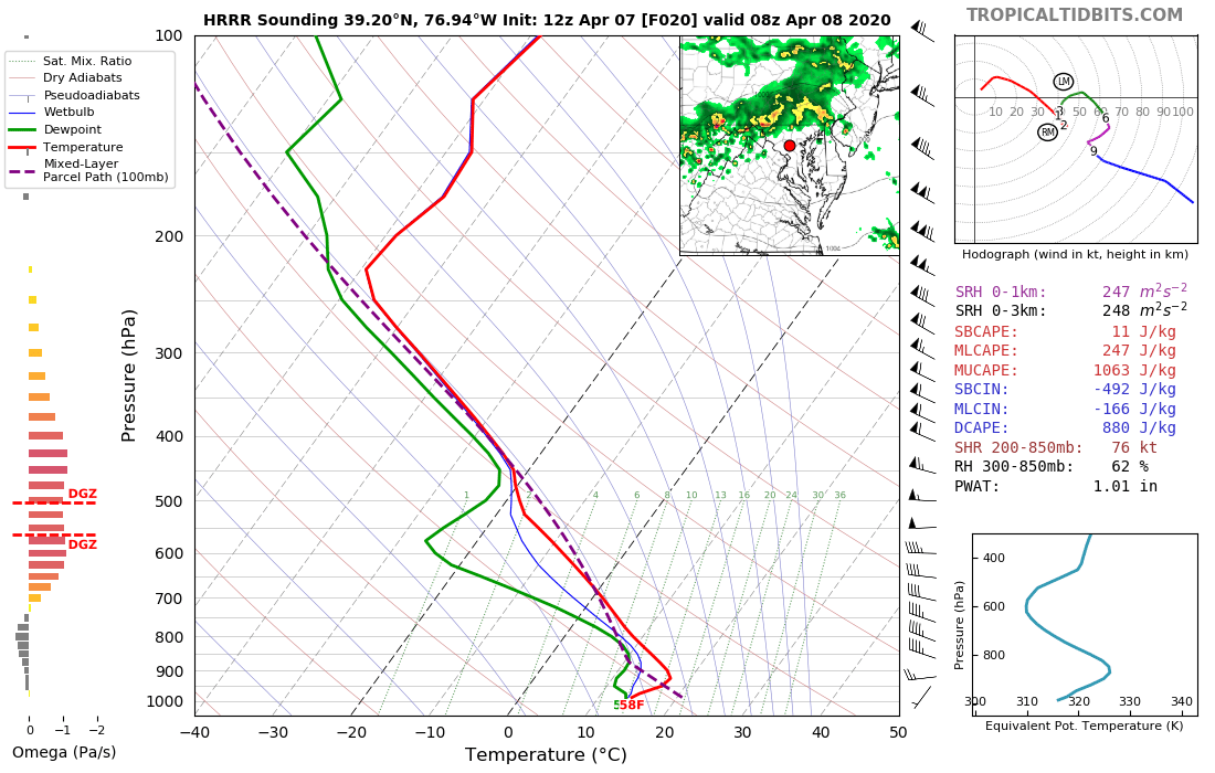
yeah, I feel good about convection in the area during the evening. The soundings just don't look great, though, in terms of any severe potential. but the soundings ahead of the late night line show lapse rates and most unstable cape values that are not common around here. That's why I think that this is our best chance on the Maryland side for severe (hail).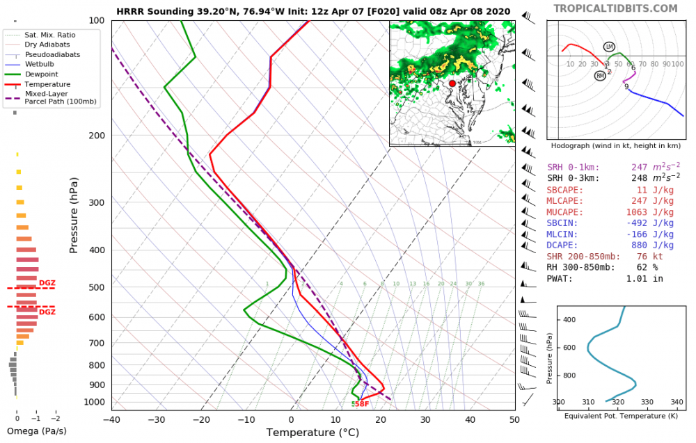
-
2020 Mid-Atlantic Severe Weather - General Thread
high risk replied to Kmlwx's topic in Mid Atlantic
The late afternoon storm threat looks to be on the west side of DC, but I like the chances for a lot of us to hear thunder in the early evening. The time period to watch, though, may be the 3-6 am period, when multiple cams show a line racing southeast across the area. It will be elevated, but impressive lapse rates will be overspreading the area, leading to some severe hail potential. -
2020 Mid-Atlantic Severe Weather - General Thread
high risk replied to Kmlwx's topic in Mid Atlantic
Looking at the CAMs, it looks like round 1 develops as a weakening Ohio Valley MCS undergoes intensification in central VA early Tuesday afternoon and rolls southeast. For the rest of us, our best chance appears to be in the evening hours, when storms that initiate in the late afternoon over eastern OH move southeast towards us. (A few solutions have another batch of storms rolling through from the northwest in the early morning hours Wednesday). Lapse rates look good, so I like our thunder chances - the potential for SVR will depend on how warm we get Tuesday afternoon and stay into the evening hours. While I like our thunder chances with that event, I'm less excited about SVR potential, as I think they'll be elevated, although I suppose I can't rule out some hail. -
2020 Mid-Atlantic Severe Weather - General Thread
high risk replied to Kmlwx's topic in Mid Atlantic
definitely. and SPC today mentions the mid-Atlantic for both Wednesday and Thursday. A quick check of the morning guidance suggests that the timing is off here for good potential on both days, but there is certainly time to adjust the setup. -
2020 Mid-Atlantic Severe Weather - General Thread
high risk replied to Kmlwx's topic in Mid Atlantic
These soundings aren't too bad - wind profiles in the lowest 1 km are a bit weak but still fairly good. Kmlwx has a good analysis - the problem is that not much guidance shows robust convective development in this area. The one way we could sneak into a better event is if the NAM nest is correct about the slow progression of the warm front. If a cell interacted with that boundary, it could get interesting. -
2020 Mid-Atlantic Severe Weather - General Thread
high risk replied to Kmlwx's topic in Mid Atlantic
wow! low-level directional shear is lacking a bit, but the low LCLs and impressive low-level cape would make that a volatile environment. Even if we chop off a few degrees from the T and Td, it's still scary. -
2020 Mid-Atlantic Severe Weather - General Thread
high risk replied to Kmlwx's topic in Mid Atlantic
for us on Sunday, right now the forecast soundings look terrible with limited instability and weak low level flow. It's also unclear whether the cool air will erode over the northeastern half of this subforum. Gonna need a huge improvement in the setup to give us anything of interest. -
2020 Mid-Atlantic Severe Weather - General Thread
high risk replied to Kmlwx's topic in Mid Atlantic
1500 is probably enough cape to handle that kind of instability, especially given that it's not "tall, skinny" cape, and there is enough low-level instability for good parcel accelerations. The forecasted soundings keep getting better, and SPC now has a day 2 MDT which looks justified. Still questions about evolution of elevated convection earlier in the day and resulting impact on how far north the warm front can get, but areas just south of wherever the warm front ends up look primed.