

osfan24
-
Posts
3,679 -
Joined
-
Last visited
Content Type
Profiles
Blogs
Forums
American Weather
Media Demo
Store
Gallery
Posts posted by osfan24
-
-
2 hours ago, CAPE said:
Hint: I never said anything about expectations for snow this winter because it's a Nino. He read into that/ had some preconceived notion or whatever the hell and went off on some tangent about certain people here being crazy for thinking average climo snowfall is ok this winter. HE HAD NO POINT. Still not sure why you replied with all this superfluous crap lol.
I had a point. You just disagreed with it. I don’t recall attacking anyone, either. I just said people who think climo in a Nino is good are crazy. Your constant posts about my one post have been far more egregious than anything I said, not that I take offense, but it’s comical.
Your post literally said we just came off a great week (true) and that if we could repeat it again, it would be a typical season at this latitude. That’s just not true for a Nino . We’ve had about 10 inches of snow. BWI is at 9.2 I believe. If you double that, it is literally climo. It’s not terrible in a Nina. In a Nino, that’s not good. That was my only point. And the fact you seem to think it’s good is why I posted.
-
2 hours ago, dallen7908 said:
I should probably put something together but I was just going with the following:
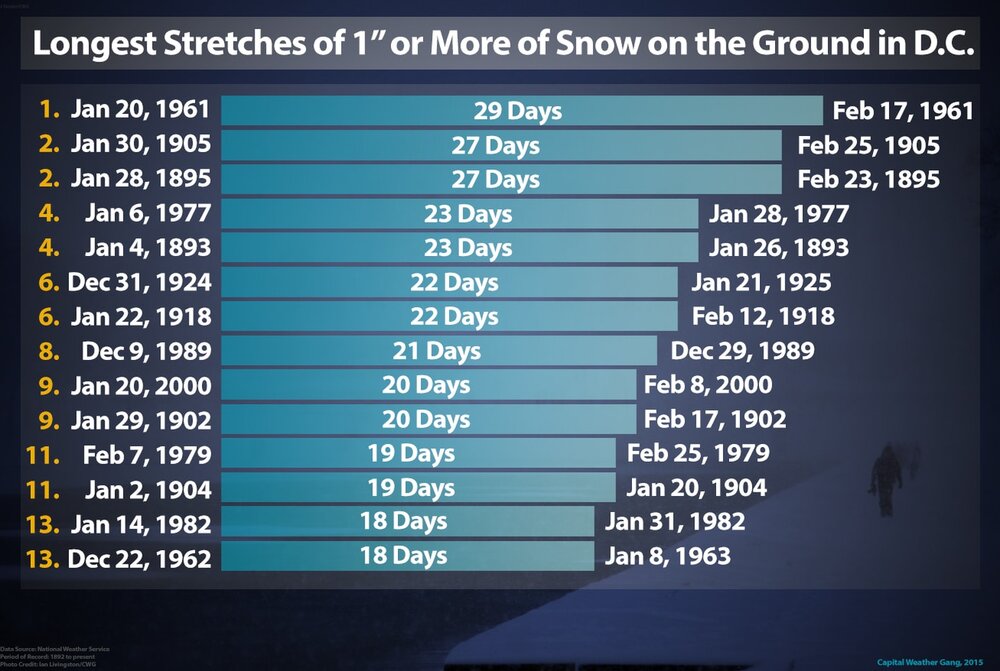
I am shocked 2014 isn’t on this list. I know it’s for DC, but 2014 to me was just an incredible winter between the constant light to moderate snowstorms and incredible cold. Even 2015 seems like it could make a run at that list.
-
 1
1
-
-
1 hour ago, CAPE said:
How many weeks of actual winter weather did we have the last time there was a strong Nino? Be careful calling people crazy when you drop turd posts like this.
Like one. But we were unlucky, and we still got a HECS, which we still could get! But that isn’t relevant to the point I am making, which has nothing to do with whether or not I think this season will end up great or a dud or anywhere in between.
My point was that I am confused that some posters seem to think reaching climo in a Nino is good and it’s not. If we swing and miss on Nino’s, or even if we end up reaching climo in them, your average seasonal snowfall is going to be basically cut in half. And yes, sometimes a Nino doesn’t work out and you get screwed. But you don’t want that becoming a pattern. So let’s say BWI averages 20 a year and reaches 20 this year. Some people will think that’s great. It’s actually pretty bad and if it continues, BWI’s real average is going to drop to like 10 inches a year. Might even be less than that. Congrats, you are now Charlotte!
2009-2010 was amazing. I’d love to see it again even though it was once in a lifetime. But we don’t need 2009-2010 to have a successful Nino. No one is saying we need 100 inches of snow. But do we need something like 2003? Yeah, we do.
-
4
-
-
59 minutes ago, CAPE said:
Amazingly, neither of you seem to know where you live. We are just coming out of a 10 day period of legit winter that produced a moderate amount of snow in the lowlands. If we get another 10-14 days with a pattern that can deliver below avg temps with a favorable storm track, that is a pretty typical winter at this latitude outside of the western highlands and PSU land.
Also a reminder- These sort of posts belong in the Panic Room thread.
But it’s not average for this type of nino. Some of you are crazy. The average winter is literally the average of the few really good winters that are Nino’s where we crush it and a lot of crappy other seasons that are Nina or neutral. Hitting climo in a nino is a failure. You suffer through the last seven years for this year.
-
1
-
 1
1
-
 1
1
-
-
3 minutes ago, Ji said:
of course i was hoping it would be a feb 1 to Feb 20 window.....but it is what is. Feb 10-March 10. Lets see what happens.
Area wide we are in the 10-13 inch zone right now
One Mecs of 15 and one Secs of 8 puts us 33-36. Thats a very good winter
One Hecs of 25 and one secs of 5 puts us 40-45 inches...that would be pretty epic around
One Hecs of 35 and a secs of 3....would put us over 50
HECS or bust.
-
1
-
-
6 minutes ago, Terpeast said:
Yeah I need a break, too. I can’t imagine a year like 2013-14 while working remotely and taking care of my daughter who is almost 3. After a crazy week, I took a nap today and slept for almost 4 hours!
I think I’d find a way to survive, lol, but yeah, I remember that year being exhausting. I also think the period from like mid January through early February in 2010 was tiring as well. But I’d be cool running that back!
-
2
-
-
5 minutes ago, brooklynwx99 said:
i don't think this would have snowed in 1873 with this antecedent airmass
I think his point is the air mass wouldn’t have been that torched in the past during late January, especially when it was very cold a week prior.
-
2
-
1
-
-
2 minutes ago, psuhoffman said:
Actually the very end of the gfs was only a few days from a better pattern. It was evolving the way we want at the end. The first week of Feb is likely toast. Accept it. If we can get out by Feb 10 it’s a win. Gfs was heading that way.
If we can get to it by Feb 10, I guess that gives us 4-5 weeks to make things happen. But will it be like what happened in January where it then took weeks to get the cold necessary to actually snow? We need the pattern to set in quickly because, on top of the need for cold, we also usually need a few chances before we actually connect. We usually score on the backend of the good pattern, not at the start or even that much in the middle.
-
2 minutes ago, Bob Chill said:
I threw an edit in my last post. I dont want to come off like I'm canceling anything because I'm most certainly not. And I strongly believe winter will make a return. But man there were some high expectations going into this one. It would be a let down for me if @WxUSAFs guess happens and half the forum walks away sour lol. His guess is basically identical to what I'm thinking and I'd be more surprised if we didn't get another warned event. Just maybe not widespread 1-2'.
The one wildcard in my head is March. For many years I expected March to be a spring month and it was right. That's changed. Maybe just cycles in cycles or maybe because oceans are warmer and it shifts climate bookends. Not sure but lately March has been better than many Dec/Jan's. March ninos are generally bad here but the front half of March can produce big storms. Maybe big storm window ends up there instead of Feb. We'll see
That would be hard to swallow. This week has been fun between the two overperformers and the cold surrounding it, making it feel like deep winter. Plus, the squall day before all of it also seemed to overperform.
But outside of that and the one dusting in December, assuming nothing happens next Sunday, which is an extreme long shot, this winter has to be like a D or D+ given expectations, especially now that it looks like we might have nothing to even track until at least mid February. It basically forces us a huge heater over the final month to have a chance for this to meet expectations. Of course, one HECS could do it, but I keep hearing certain people constantly say the upcoming pattern is amazing, hyping up HECS and everything else and not only hasn’t it happened, but it really hasn’t been remotely close.
-
3
-
1
-
-
I know it’s just one run of one OP and it’s an OP, but man, unless we fluke into next Sunday. It looks really, really ugly. Like shut the blinds until at least mid February.
-
1
-
-
32 minutes ago, clskinsfan said:
GFS is pretty close for next Sunday. That is a stout HP over the top. Better timing and its a good storm.
Ravens snow game for AFC title?!?!?
-
1
-
-
Streamers look awesome. Hoping they slide a bit east to hit Hoco.
-
2
-
-
2 minutes ago, Kmlwx said:
Light rates and sun through clouds. If you wanted it to stick around you shouldn't have shoveled

I thought the rates would pick back up. Models seemed to have steady snow most of the day today. This has basically been drizzle most of the day.
-
8 minutes ago, WxUSAF said:
5.4”, 0.1” last hour. That looks like it pending streamers. Snow peaking through even it is still snowing very lightly.
Yeah, I'm done with this. Driveway is almost completely melted after I shoveled a few hours ago. Been basically nothing since 11. Let's see if we can get under some nice streamers. Looks like they might be a bit too far west and northwest but we shall see.
-
20 minutes ago, jayyy said:

Most reports came between 11am & noon. HoCo - MoCo into Loudon stand upOuch, that 5-8 in Northern Maryland is going to fail miserably.
-
1 minute ago, yoda said:
000
NWUS51 KLWX 191831
LSRLWX

Preliminary Local Storm Report...Corrected
National Weather Service Baltimore MD/Washington DC
131 PM EST Fri Jan 19 2024

..TIME...   ...EVENT...      ...CITY LOCATION...     ...LAT.LON...
..DATE...   ....MAG....      ..COUNTY LOCATION..ST.. ...SOURCE....
            ..REMARKS..

0100 PM     Snow             Bwi Airport             39.18N  76.65W
01/19/2024  M4.1 inch        Anne Arundel       MD   Official NWS Obs


&&

Corrected remarks

Event Number LWX2401798
I believe this puts BWI right at 10 inches even on the season, unless they recorded something the day of the snow squall. I know they somehow didn't record anything with the December snow.
-
3 minutes ago, mdhokie said:
Where you at?? I'm down by 103/100 and it was pretty heavy 8-12pm. Probably have 5" total. Last hour or so its been very light, fine snow.
I am just east of where 40 and 70 meet up. There were some short bursts of maybe moderate snow in that period where the flakes were really nice but it seemed to flip back to snizzle pretty quickly. It's been mostly snizzle the past 2-3 hours. I must have had 3-4 on the ground when I woke up and it feels like I haven't added all that much since then.
-
Snow overnight, which unfortunately I slept through, was very good. Snow today has been largely disappointing, especially given what some of the meso models showed. Other than a few better bursts, it's been mostly snizzle here and all cleared, paved surfaces have been melting for a couple hours. Light rates combined with less dense cloud cover has let the sun do its thing at these temps. Not seeing the pivot or any impact from the inverted trough this way yet.
-
1
-
-
Going to need some rate increases to see anyone get to the 8 inch mark. I actually thought double digits might be possible for some isolated areas this morning. I wonder when the inverted trough sets up and if we get a pivot later this afternoon.
-
Looks like a nice band just to my west.
-
2
-
-
5 minutes ago, baltosquid said:
If the coastal gets going and the banding is good, maybe. Certainly going to be someone enjoying some wraparound fluff in the early afternoon.
I wonder if that norlun trough is going to get going and where exactly it will happen.
-
1 minute ago, WVsnowlover said:
Last three GFS runs. The trend is our friend. Big changes in Kentucky. Maybe that translates here later?

GFS seems a bit on an island with how dry it is overall.
-
1 minute ago, AlexD1990 said:
DT on FB talking about upping his numbers on his next snowfall map

But what will he have on his 6th call map?
-
3
-
-
1 minute ago, NorthArlington101 said:
it is - that map jumped the gun

That's more in line with what I expected, thanks!
-
 1
1
-

Jan/Early Feb Medium/Long Range Discussion Part 3
in Mid Atlantic
Posted
Give it a rest? Says the guy who made numerous posts about it over the past 3 pages of the thread. I made an original post, and then just responded again. But yes, I’ll give it a rest.
Your point was a repeat of what we already had would be a typical snowfall for the season. My point was that’s not the case for a Nino and nuance matters.