

Yanksfan
-
Posts
1,130 -
Joined
-
Last visited
Content Type
Profiles
Blogs
Forums
American Weather
Media Demo
Store
Gallery
Posts posted by Yanksfan
-
-
Meh, I’ll wait till the overnight runs on Friday before I buy into this. Far too often these thread the needle deals goes poof on us although at this early juncture it’s always good to have the CMC/EURO on board.
-
11 hours ago, MJO812 said:
Can someone please change my name back. Thank you.
Don’t worry Ant. I just took one for the team. I’m no longer NutleyBlizzard.
-
 1
1
-
-
-
17 minutes ago, ILoveWinter said:
This much pessimism after a bad run by one model at 18z 4 days out from the event? Way too early for that! (or being overly optimistic for that matter)
A 698 day snowless streak will do that to you.
-
1
-
-
Any improvements with this mornings EURO 6Z run?
-
The Jan. 20th threat on the EURO is suppressed and OTS as well.
-
GFS at 6Z is on board for a snowstorm for next Tuesday. EURO continues with the threat as well.
-
 1
1
-
-
1 minute ago, mannynyc said:
GEFS
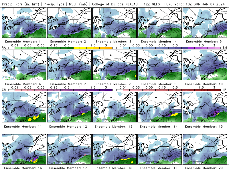
A good number of big hitters in there. Looks colder too.
-
1
-
1
-
-
Just now, bluewave said:
These global models haven’t had much success with the proper placement of the rain-snow line near NYC at the 72-96 hr range. It usually comes down to mesos like the NAM to correctly diagnose the warm tongue from the ESE and the other models have a cold and weak bias with this feature. Unfortunately, the NAM hasn’t been updated since 2017. And several models like the HRRR have had a cold bias. So I hope they can come up with a suitable NAM replacement before retiring the model.
I’ll follow the Nam but I don’t take it seriously until it’s within 36 hours of game time. The go to model for me is the RGEM.
-
1 minute ago, NEG NAO said:
I bet the 0Z EURO tonight looks different
The EPS will be telling.
-
3 minutes ago, Allsnow said:
06z gfs was colder and further southeast then 00z. The high and confluence really helping locations closer to the coast
The run looked wonky to me. Low was really stretched out and scooted east thus the lower amounts.
-
1
-
-
1 hour ago, Allsnow said:
Happy hour gold at the end of the gfs lol.

Sure it’s the 384 GFS, but taken verbatim that’s a HECS pattern right there.
-
2
-
 2
2
-
-
35 minutes ago, MJO812 said:
Crazy gfs differences from 12z
Looked like the beginnings of an east coast snow mauler at the end of the run. One can only dream.


-
2
-
1
-
-
22 minutes ago, MJO812 said:
Looks like the weeklies from a few days might be right with a developing winter pattern by the end of this month .
We can only hope. I’m getting ticked off with all these rainstorms.

-
2
-
-
ENSO 1.2 down to .89 according to tidbits.

-
2
-
1
-
-
12 minutes ago, Stormlover74 said:
Farmers almanac bs
As we already know there will be other factors in play this winter. What will the PNA and NAO do?
-
1
-
-
23 minutes ago, MJO812 said:
We can only hope.
-
1
-
-
53 minutes ago, so_whats_happening said:
Not a bad forecast and generally agree. He has showed us tidbits throughout the summer so it shouldn't come as a big surprise to folks what the final outlook was. I wanna see how the rest of this month shakes out, I don't do seasonal forecasts, but like the idea of the overall temp trends that will happen this month to being how winter goes. Warm start of the month equal to a rather warm December, to a mild and more tame temp profile mid month eqaul to January and potentially cold latter third of the month eqaul to a cold February. Precip probably a bit too variable to know for certain for me at least.
If there’s any indication what we’re seeing thus far this fall with all the coastal development, I would have gone higher with the precipitation up into the mid Atlantic . My thinking in the 125%-150% range. Overall good forecast.
-
1
-
 1
1
-
-
17 minutes ago, bluewave said:
This is currently a split flow pattern with the PAC Jet dominating over the STJ. That big jet extension all the guidance is showing is what we usually see with La Ninas this time of year. So the -PDO pattern is really pushing back against the El Niño development at the present time. The firehose jet will give cause the -EPO to flip to an +EPO and erode the +PNA ridge.

A raging Pac jet is the last thing we need this winter. We all know what happened the past three years with this stubborn feature.
-
Wow I didn’t realize that Decembers have been that warm in recent times. I yearn for the days growing up when most years followed certain guidelines. Turning colder towards Thanksgiving with some flakes in the air, followed by bouts of cold and snowy conditions up until mid January when the 7-10 thaw would kick in. Finally the snow and cold bouts would come roaring back till the end of February/early March. Those winters around here are a distant memory.
-
1
-
-
2 hours ago, bluewave said:
All we can say that is the summer matched a warmed up weak El Niño MEI composite. September has had mixed El Niño and La Niña influences. So it wouldn’t be a surprise if we see more back and forth going forward like the models show. Obviously, El Niño winters are typically backloaded for their best effects. So it’s still way too early to know how the typically best part of the winter plays out. Our sample size of El Niño experiences since the WPAC warm pool has greatly warmed is pretty small. 15-16 was well coupled and we still got a Niña-like month in December before the heart of the season. So everything worked out once we got a great El Niño blocking pattern. 18-19 was showing signs from the fall of not being able to couple which carried though the winter. So hopefully we see improved coupling going forward in time for the typical back loaded portion of El Niño winters. Probably a range of possibilities based on competing Nino-like or La Niña influences. Obviously, we would want a clean El Niño pattern to dominate the typically back loaded portion with blocking and a great STJ.
Best case scenario for snow lovers would be a primarily Niña based background for December. Nina’s typically are front loaded winters, followed by Nino coupling in January.
-
2
-
-
7 minutes ago, snowman19 said:
You’re not going to like NOAA’s brand new winter outlook lol Hot off the presses: https://x.com/climatologist49/status/1704948077667467448?s=46&t=NChJQK9_PUjA1K7D2SMojwNOAA predicting a warm winter? Shocking!
-
1
-
 1
1
-
1
-
-
For arguments sake let’s say we peak at a strong ElNino that ends up being decoupled. What effects good or bad would influence the upcoming winter?
-
38 minutes ago, brooklynwx99 said:
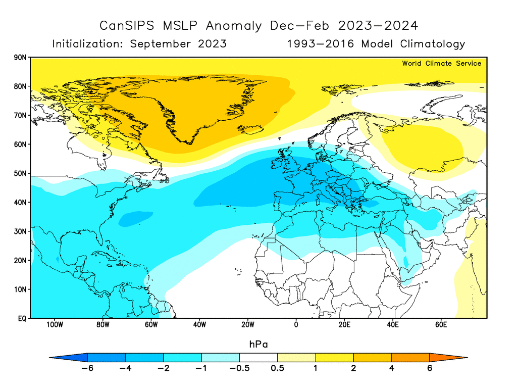
new CanSIPS has pronounced blocking. wow
that's the DJF mean, too. Feb probably looks insane
Oh my.


Sunday 1/28-midday Monday 29/2024 snowfall and OBS most of the NYC subforum including potential 1/2-2" NYC-LI-heavier toward I84.
in New York City Metro
Posted
6Z GFS is a tick colder.