backedgeapproaching
-
Posts
3,819 -
Joined
-
Last visited
Content Type
Profiles
Blogs
Forums
American Weather
Media Demo
Store
Gallery
Everything posted by backedgeapproaching
-

January 16 2021 - Inland runner Rain/Snow/Wind
backedgeapproaching replied to Baroclinic Zone's topic in New England
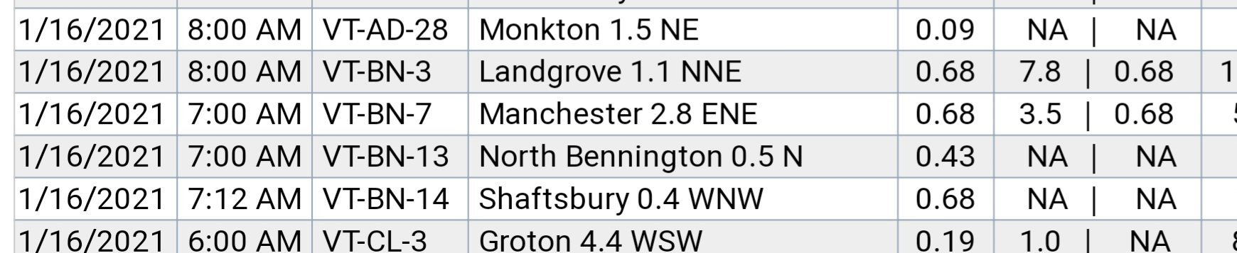
Kind of interesting looking at SVT cocorahs. Three stations in Bennington County reported exactly .68" precip. Landgrove had 7.8" on .68 LE near 1900ft My place had 3.5" on .68 LE near 1100ft Shaftsbury had 0.0" snow with. 68" rain also at 1100ft-- but a few miles removed for the spine so probably warmed just enough on the downsloping winds to remain all rain.
-
January 16 2021 - Inland runner Rain/Snow/Wind
backedgeapproaching replied to Baroclinic Zone's topic in New England
Right, thinking 10:1 for you since you were at 29-30F for most of it. LE here not that far off from you and greenmtnwx, just little too warm--which was expected. -
January 16 2021 - Inland runner Rain/Snow/Wind
backedgeapproaching replied to Baroclinic Zone's topic in New England
Did you do a LE measurement yet? Curious how much is in that. Almost .70" here, but not quite 4" snow with temps just above freezing bringing ratios way down. -
January 16 2021 - Inland runner Rain/Snow/Wind
backedgeapproaching replied to Baroclinic Zone's topic in New England
3.6" here. Got to be 5-6:1 ratio. Enough dynamics to go almost isothermal, even here in the valley. Hovered around 32.1-32.7F for most of the overnight, total mashed taters. -
Agree with PF..over 1200 ft with some SE flow upslope assist think you could do better. Going strictly by that map, I cant see Manchester getting more than your area unless the backside west flow upslope delivers.
-
January 16 2021 - Inland runner Rain/Snow/Wind
backedgeapproaching replied to Baroclinic Zone's topic in New England
They will be fine IMO..Stratton and Bromley are both about 2k at the base. -
January 16 2021 - Inland runner Rain/Snow/Wind
backedgeapproaching replied to Baroclinic Zone's topic in New England
Still could be-just most likely at 2K. Maybe Mitch has a cot he can roll out..ha. -
That would be roughly my guess here--I'm also tucked in close on the Western slopes, so not as ideal as 1100' on the eastern side. Would say less than 3-6 for DDH up through RUT below 1K in the valley.
-
Yea, it was already a steady stream of out of staters rolling in this morning. Busy weekend upcoming.
-
January 16 2021 - Inland runner Rain/Snow/Wind
backedgeapproaching replied to Baroclinic Zone's topic in New England
Right--mean little less weenie-ish. Didn't even notice I posted max. -
January 16 2021 - Inland runner Rain/Snow/Wind
backedgeapproaching replied to Baroclinic Zone's topic in New England
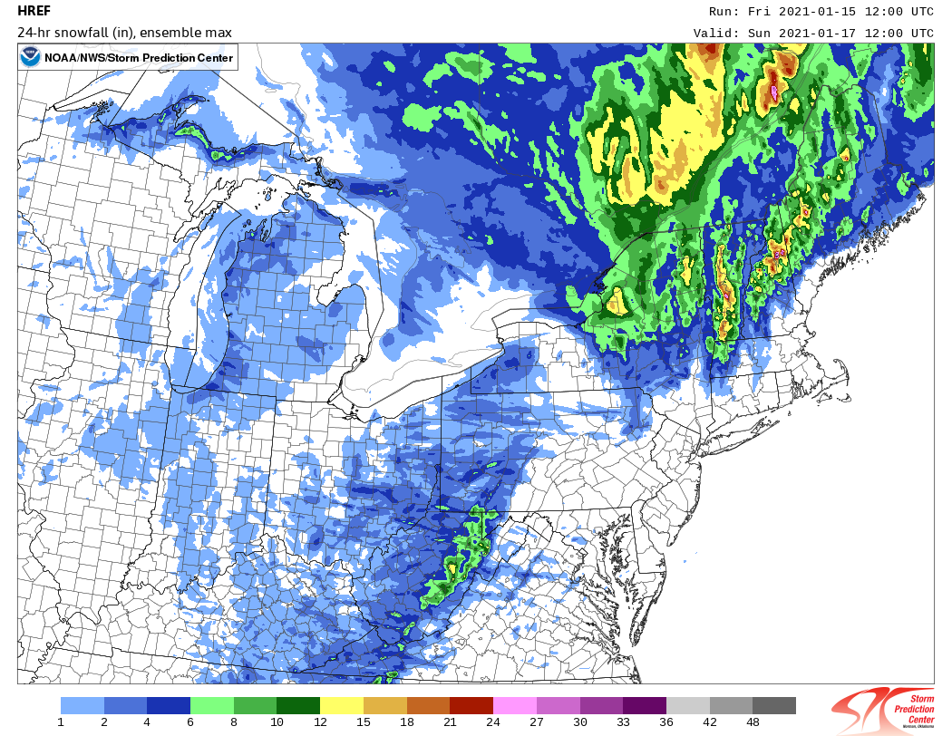
HREF from this morning. Nice to be on the Eastern Slopes with elevation for this one.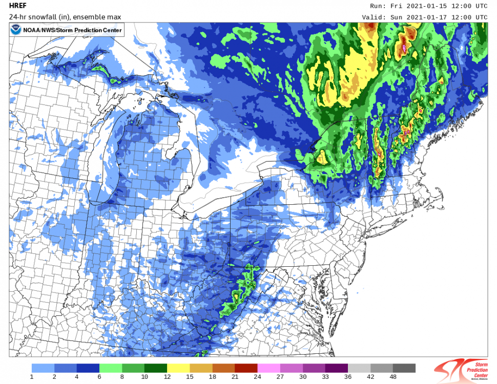
-
Shame it's a stale airmass by mid Jan standards--would get alot more people in the game with LP track possibly trending a bit better.
-
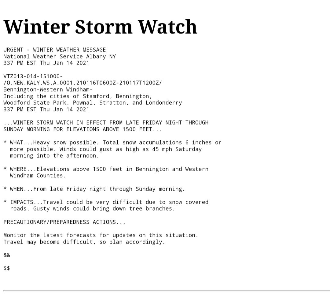
ALY going with 1500' as the magic number---for this event at least..

-
Yes, near or north of Caribou is pretty much perfect for N Greens upslope. Track was better yesterday for Southern Greens with the LP sitting and spinning between Montreal and Quebec City. Still time to figure out exactly where this thing ends up.
-
If you could live anywhere in New England
backedgeapproaching replied to TalcottWx's topic in New England
Just going anecdotally from license plates--NJ to me is far and way most represented here, then CT and NY. Mass/PA and then a hodgepodge of everything in between. -
Right, that's the way rainer's should be---not 24 hours of 50F Dews that wipes out everything in sight. I think those that are In and Up will see a net gain.
-
BTV going very elevation dependent which is not surprising.
-
For sure.. NAM and Reggie are pretty similar(in a bad way) but it's still long range for those mesos. Stick with globals for now, but keeping an eye open for that as an option too.
-
Well, you know I'm not referring to the Dacks...its bad for everyone in this forum. Although it does have the backside upslope up and down the spine and over into N NH after it moves into Southern Canada.
-
00z NAM pretty damn fugly.
-
Good reliable plumbers are also tough around here. My wife's Dad was a local builder here for 30 years and his plumber he used for 20 of them still kind of blows us off even with the so called "connection"..ha
-
They sized you up from a mile away with those MD plates and massive log home..lol
-
Kind of like SVT for ALY--seem like the forgotten sibling at times..ha. But where the METs live and where most of the population live is the capital region, so makes sense.
-
Ok, I remember there was someone who was very briefly on here when I moved in 2014, must have left soon after that. I had no clue about the microclimates here and remember asking during a huge cutter with a raging LLJ and SE winds "why is it so damn windy here?" Ha. I think he was the first one that informed me about the Western slopes downsloping.
-
PF can confirm, but in the past if I recall they have been something like-- " PF will enjoy the fresh 4-8" at the picnic tables". Something along those lines.