

ILSNOW
-
Posts
1,606 -
Joined
-
Last visited
Content Type
Profiles
Blogs
Forums
American Weather
Media Demo
Store
Gallery
Everything posted by ILSNOW
-
Something to track for the Chicago crew before the non thread the needle event.
-
Winter 2022/23 Short/Medium Range Discussion
ILSNOW replied to Chicago Storm's topic in Lakes/Ohio Valley
Another Rainer -
-
Winter 2022/23 Short/Medium Range Discussion
ILSNOW replied to Chicago Storm's topic in Lakes/Ohio Valley
0z GFS trying to make things interesting -
Winter 2022/23 Short/Medium Range Discussion
ILSNOW replied to Chicago Storm's topic in Lakes/Ohio Valley
Minneapolis hasn’t had snow in 48 hours they are due!! -
Awesome storm for you!!!!! I just measured a .1 of inch of snow overnite !!!!!
-
Winter 2022/23 Medium/Long Range Discussion
ILSNOW replied to Chicago Storm's topic in Lakes/Ohio Valley
Looking forward to mid to late January when we have another chance of 5-6 days of actual winter. -
Pre-Christmas (Dec 21-23rd) Winter Storm
ILSNOW replied to Chicago Storm's topic in Lakes/Ohio Valley
Chicago NWS Izzi Issued at 305 PM CST Mon Dec 19 2022 Blizzard expected Thursday night into Friday... Wednesday through Monday... * Travel impacts expected to begin Thursday, mainly western CWA * Rapidly deteriorating conditions Thursday evening as a ferocious arctic front rips across the area resulting in temperatures rapidly falling through the teens into the single digits * Blizzard conditions will develop Thursday night, especially late, and continue through the day Friday * Bitterly cold wind chills expected during the height of the storm, posing a significant threat to life for anyone who becomes stranded in the storm After extensive collaboration with WPC and neighboring offices, have opted to hoist a long lead time winter storm watch for blizzard conditions Thursday night through Friday night. Models and their respective ensembles have remained locked into solutions depicting rapid cyclogenesis Thursday into Friday as the cyclone tracks from southern IL to lower Michigan. Various models depict explosive deepening of this low with central pressure dropping 25-35mb in 24 hours. This type of explosive intensification is quite rare in this region and is expected to result in extremely powerful and potentially damaging winds late Thursday night and especially Friday. The deformation band with this cyclone is expected to be quite intense owing to the extremely strong omega and weak static stability/slantwise instability. Very steep mid-upper level lapse rates do raise concerns about the potential for thundersnow even later Thursday night into Friday morning. Expecting snow to liquid ratios to average around 15:1, possibly 20:1 western CWA where DGZ will be deeper. The one factor that *should* keep the snow:liquid ratios somewhat in check is the very strong winds which would tend to rip about the larger/fluffier dendrites. Have seen some general downward trend in QPF values over the past 24 hours in guidance, but QPF generally still supports widespread 6" totals with even 1-2 foot totals possible associated with any more intense banding/possible thundersnow. We are still very far out and not planning to advertise snowfall amounts in public products at this time, as much could change between now and then. It is also worth stressing that the amount of snow that falls is a secondary or tertiary concern among the hazards. The expected temperatures will leave this snow extremely susceptible to blowing around and even if only a couple inches of snow falls, a blizzard would still be likely given the nature of the snow and magnitude of the strong winds. This is one of the reasons for the early winter storm watch. Impactful winter weather, in the form of accumulating snow is expected to begin in the western portions of the CWA during the day Thursday. However, opted not to include this portion of the storm in the winter storm watch as the threat level of this snow will dwarf what will be expected during the blizzard portion of the storm. If current guidance is close to verifying, then conditions Friday could rival the 2011 Groundhog Day blizzard, particularly in open areas. Travel would become extremely dangerous and life threatening, particularly in light of the bitterly cold temperatures during the height of the storm. Falling snow is expected to end Friday afternoon or evening, but strong winds and blizzard conditions are expected to continue Friday evening and only slowly abate through the night. Some blowing snow will likely continue into Saturday with bitterly cold temperatures through the holiday weekend. - Izzi -
Pre-Christmas (Dec 21-23rd) Winter Storm
ILSNOW replied to Chicago Storm's topic in Lakes/Ohio Valley
Precip map liking Alek -
Pre-Christmas (Dec 21-23rd) Winter Storm
ILSNOW replied to Chicago Storm's topic in Lakes/Ohio Valley
12Z GEFS -
Pre-Christmas (Dec 21-23rd) Winter Storm
ILSNOW replied to Chicago Storm's topic in Lakes/Ohio Valley
12z RGEM -
Pre-Christmas (Dec 21-23rd) Winter Storm
ILSNOW replied to Chicago Storm's topic in Lakes/Ohio Valley
and 84 -
Pre-Christmas (Dec 21-23rd) Winter Storm
ILSNOW replied to Chicago Storm's topic in Lakes/Ohio Valley
ouch -
Pre-Christmas (Dec 21-23rd) Winter Storm
ILSNOW replied to Chicago Storm's topic in Lakes/Ohio Valley
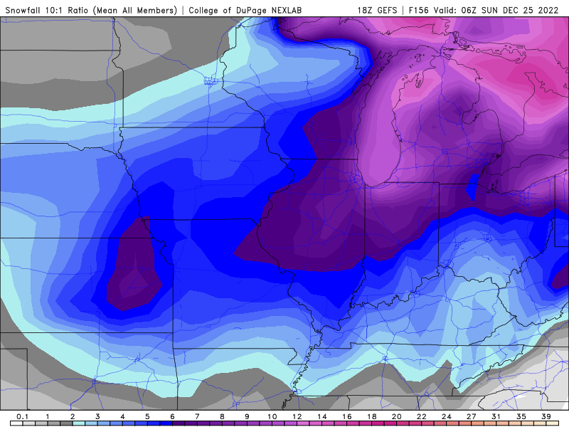
The 0z GEFS is actually a better run for N IL then the 18z. 0z And the 18z run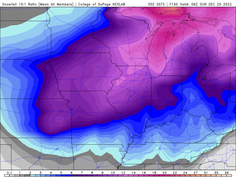
-
Pre-Christmas (Dec 21-23rd) Winter Storm
ILSNOW replied to Chicago Storm's topic in Lakes/Ohio Valley
Most of these ensembles are great hits for N IL thru 126 (especially #20)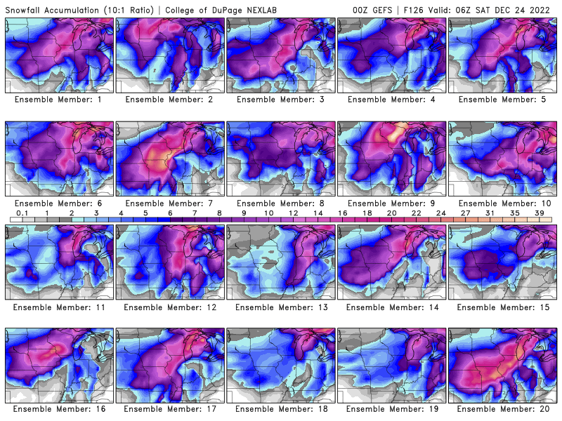
-
Pre-Christmas (Dec 21-23rd) Winter Storm
ILSNOW replied to Chicago Storm's topic in Lakes/Ohio Valley
GFS total precip -
Pre-Christmas (Dec 21-23rd) Winter Storm
ILSNOW replied to Chicago Storm's topic in Lakes/Ohio Valley
GDPS 10:1 -
Pre-Christmas (Dec 21-23rd) Winter Storm
ILSNOW replied to Chicago Storm's topic in Lakes/Ohio Valley
Thanks -
Pre-Christmas (Dec 21-23rd) Winter Storm
ILSNOW replied to Chicago Storm's topic in Lakes/Ohio Valley
Chicago can you/are you allowed to post the map? thanks -
Pre-Christmas (Dec 21-23rd) Winter Storm
ILSNOW replied to Chicago Storm's topic in Lakes/Ohio Valley
6z GEFS run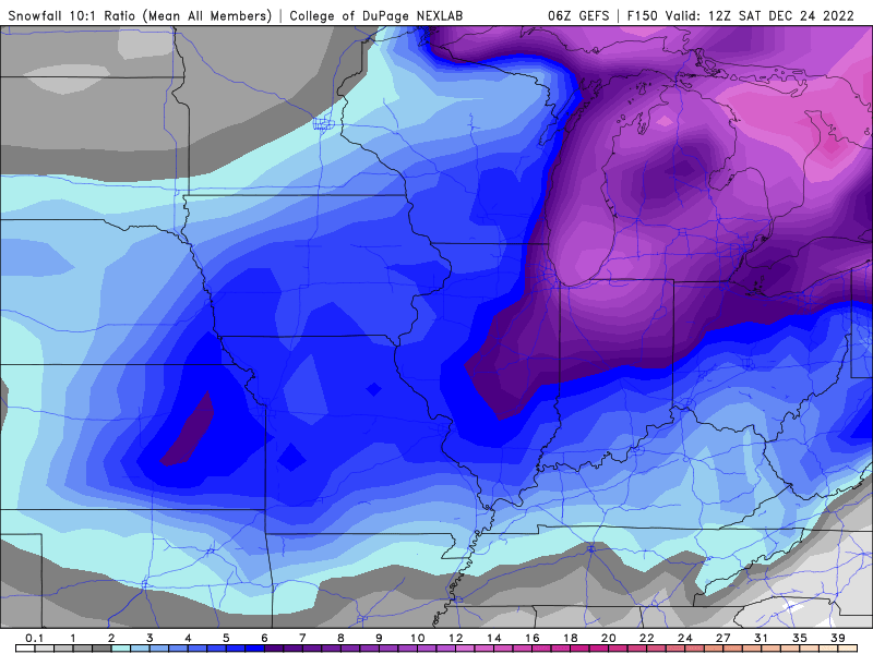
-
Pre-Christmas (Dec 21-23rd) Winter Storm
ILSNOW replied to Chicago Storm's topic in Lakes/Ohio Valley
GEFS has some big hits and some total misses. -
Winter 2022/23 Medium/Long Range Discussion
ILSNOW replied to Chicago Storm's topic in Lakes/Ohio Valley
Would be a Christmas snow to remember !!! -
Winter 2022/23 Medium/Long Range Discussion
ILSNOW replied to Chicago Storm's topic in Lakes/Ohio Valley
10 days out may be our best shot at white christmas -
In Williamstown, New York, which is about 25 miles northeast of Syracuse, 24 inches of snow was measured on Friday morning. In Hamburg, New York, which is about 12 miles south of Buffalo, 22.5 inches of snow was measured at one weather station Friday morning. Snowfall rates of 5 inches per hour were reported in Hamburg. According to AccuWeather Senior Meteorologist Dan Pydynowski, the weather station in Hamburg recorded 2.5 inches in 30 minutes on Friday morning. In Orchard Park, which is where the Buffalo Bills football stadium is located, 18.5 inches of snow was measured Friday morning. Snowfall totals at the weather station located at Buffalo Niagara International Airport, 12.5 inches of snow has fallen.
-
Just your normal 70 inch lake effect snow event


