

Jed33
-
Posts
1,005 -
Joined
-
Last visited
Content Type
Profiles
Blogs
Forums
American Weather
Media Demo
Store
Gallery
Posts posted by Jed33
-
-
Switched over to snow here too now. A decent snow shower is currently passing through.
-
 1
1
-
-
7 minutes ago, Carvers Gap said:
We received 2" more of snow overnight for a total of 3". Wind chills are 5F right now. The much anticipated northwest flow event actually was led off by a strong band of heavy snow. It did not disappoint IMBY. I got up this morning and watched it for a bit. This image is of the initial line of snow as it began to move through TRI earlier today. We probably ended up 3.5 total...1.5 yesterday plus the 2 overnight. I have 3" of snow right now on my usual measuring spots.
I wondered how it was up that way. My house is on the southern end of that band SW of Rogersville. It was absolutely ripping between 5-6 this morning. I was like a kid watching it myself. Fun times!
-
2
-
-
Wow! Woke up and the road is covered. Went out and measured 1/2in on it and my snowboard had 3/4in on it but looks like the wind has been blowing it some. From about 5-6 this morning it was ripping!
Some other landscape timbers behind the house where the wind does not blow I measured close to 2in which includes yesterday (it did not hardly melt) and overnight bringing the total to right at 2in for the 2 days!
-
5
-
-
2 minutes ago, tnweathernut said:
The last expansion of precip on radar is occurring over the next hour or so.
Yep I posted at just about the same time. Looks like it’s Central Valley north and east. Hopefully it back builds some more for even the southern valley.
-
1
-
-
Well, just when I thought it was going to stop and there was no hope of a band trying to reform, it’s snowing again and a small band is trying to reform, but unfortunately looks like it’s not going to last too long. Looks like it’s being aided by a stronger band trying to sink SE from KY.
-
2
-
-
Sitting at 1in on my snow board now. Just some very light snow falling at the moment.
-
2
-
 1
1
-
-
Got between 1/2-3/4in now here
-
1
-
-
Woke up at 3:50 and nothing. Tried to go back to sleep and was in and out of sleep. I got up at 5:45 and it had just started. It’s kinda a fine flake snow, almost a fog but it’s coming down pretty good. Beginning to see the grass whiten up. Temp is 28 dp 28.
-
1
-
-
2 minutes ago, Daniel Boone said:
Those were over here too. Looked like Mamatus. I was thinking how Weird .
Same here! I thought the exact same thing looked just like Mammatus clouds.
-
3
-
-
I’m definitely not the most knowledgeable, but I look at them every morning around 7:30 on the CPC website. It definitely is encouraging to see them meander in phase 8 and 1 as well as 2. Most ultimately go into the circle today, but 1 or 2 including the JMA stay out of it and squarely in phase 1,2,and 3. The BOMM I feel like, at least this winter is always playing catch up to the ECMWF and GFS/GEFS. If you just look at Mjo plots, you’d think winter wants to hang around well into March this year! Would be great by me!
-
2
-
-
The RGEM continues to be basically locked in.
-
4
-
 1
1
-
-
The RGEM looks good for my area as well. Almost looks like it has an upper level low or disturbance that moves in with the arctic air after the main system passes. Those are so hard to predict until they actually occur. Hopefully it’s on to something.
-
2
-
 1
1
-
-
Looks like it was a touch colder and a hair further south.
-
4
-
-
1.16 so far for me.
-
2
-
-
5 minutes ago, Silas Lang said:
Yeah, and additionally the storms last Thursday night flooded some areas already. I received 2 inches in a hour.
I know that didn't include all of Knoxville or the area, but places that got hit by that line have some pretty saturated grounds. Was the worst flooding I had seen at my house in 6 years I have lived here.
Oh man! I hate to hear that! Hopefully you didn’t have any water get in the house?
-
1
-
-
8 minutes ago, bearman said:
MRX keeps knocking back the totals they see for the valley. Did have knoxville at 6 to 8 inches. now just 2 to 3. With the dryness that we have had this does not seem to be much of a deal.
.
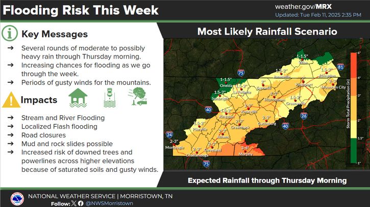
I thought that too until I looked at the bottom caption. That’s just through Thursday AM, and since we’ve already had close to or exceeding an inch in most places that looks about like their original thinking. The other map took into effect the entire week through Sunday.
-
1
-
-
Now actually full on sleet shower out there. Did not expect this, this far south. I wondered if it might with the dew points being so low, but figured I’d totally miss out on this one. Won’t be any accumulation but still kinda cool to get something out of it.
-
3
-
-
Getting some light sleet here as well. Temp is 39 dp 24 which is producing the sleet from evaporative cooling.
-
2
-
-
This is turning into quite the little severe outbreak!
-
2
-
-
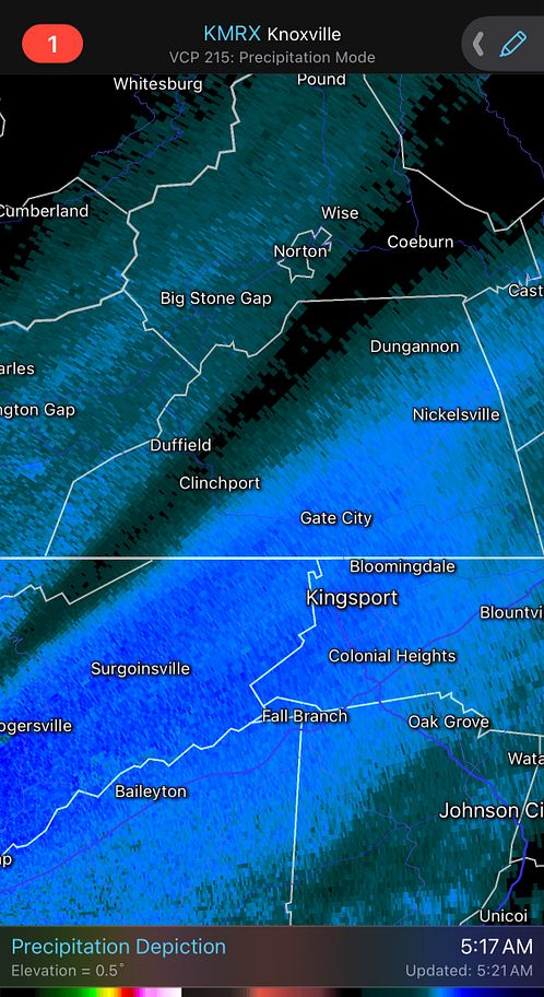
Tor warning for east side of Kingsport now!
-
1
-
-
Yes that cell is right on top of my house but it’s just heavy rain and lightning at the moment.
Edit: The Tor was just dropped to SVR PTL! Just really some moderate to heavy rain and some wind right now.
-
3
-
-
Man the lightning is intense here now and dead calm! Rain is just roaring out on the lake!
-
1
-
-
All of a sudden I’m in a Tor warned polygon. Hopefully all will be well.
The cell is coming right out of Claiborne Co near Tazewell moving E/SE it’s just about guaranteed to hit me some way shape form or fashion. We will see soon.
-
1
-
 1
1
-
-
33 and rain snow mix. Oh well. Actually have .28in of precip. That is way more precip than I expected but is good considering how dry it’s been.
-
2
-
Spring 2025 Med/Long Range Discussion
in Tennessee Valley
Posted
I did not have a true dusting at my house, but did have a tiny amount on the cars and rooftops. There must have been a few heavier bands though because there were places around town here that did receive a solid dusting.