
BBasile
-
Posts
2,209 -
Joined
-
Last visited
Content Type
Profiles
Blogs
Forums
American Weather
Media Demo
Store
Gallery
Everything posted by BBasile
-

E PA/NJ/DE Summer 2025 Obs/Discussion
BBasile replied to Hurricane Agnes's topic in Philadelphia Region
Necesitamos más, por favor. Gracias. -
E PA/NJ/DE Summer 2025 Obs/Discussion
BBasile replied to Hurricane Agnes's topic in Philadelphia Region
Still waiting for my turn! lol. Picked up 0.46" which is, oddly, exactly the same as yesterday. So, 0.92" over two days is great, especially for all the brown foliage, but... I am requesting mayhem. Just once this year? -
E PA/NJ/DE Summer 2025 Obs/Discussion
BBasile replied to Hurricane Agnes's topic in Philadelphia Region
Just an example of why some locations measure more rain than others (mine) lol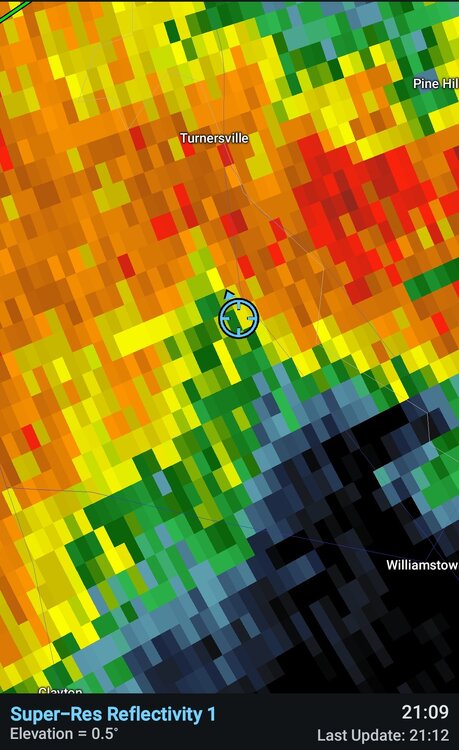
-
E PA/NJ/DE Summer 2025 Obs/Discussion
BBasile replied to Hurricane Agnes's topic in Philadelphia Region
Well, it's raining. -
E PA/NJ/DE Summer 2025 Obs/Discussion
BBasile replied to Hurricane Agnes's topic in Philadelphia Region
Still looking decent on radar and dronedar. Keep it coming! -
E PA/NJ/DE Summer 2025 Obs/Discussion
BBasile replied to Hurricane Agnes's topic in Philadelphia Region
Umm... Yep. We're good. -
E PA/NJ/DE Summer 2025 Obs/Discussion
BBasile replied to Hurricane Agnes's topic in Philadelphia Region
Good stuff! It does look like it's intensifying into Jersey. Regardless, the whole line is looking pretty damn good. I want mayhem, but I'm okay with beneficial rainfall, too. Lol -
E PA/NJ/DE Summer 2025 Obs/Discussion
BBasile replied to Hurricane Agnes's topic in Philadelphia Region
Yes! I'm jealous as hell. Just don't get flooded... Or struck. -
E PA/NJ/DE Summer 2025 Obs/Discussion
BBasile replied to Hurricane Agnes's topic in Philadelphia Region
Eat it up! Enjoy, you lucky SOB!! -
E PA/NJ/DE Summer 2025 Obs/Discussion
BBasile replied to Hurricane Agnes's topic in Philadelphia Region
Maybe not? Point remains, though. -
E PA/NJ/DE Summer 2025 Obs/Discussion
BBasile replied to Hurricane Agnes's topic in Philadelphia Region
Third time is the charm, right? Three flood watches can't equal less than .5"?? -
E PA/NJ/DE Summer 2025 Obs/Discussion
BBasile replied to Hurricane Agnes's topic in Philadelphia Region
This. But even with some with fairly steady rainfall, like with stratiform events, the rainfall totals can vary over short distances. I use all my local Davis stations on Weatherlink, and more often than not, the totals are at least a bit different. And the stations are all within a few miles of each other. -
E PA/NJ/DE Summer 2025 Obs/Discussion
BBasile replied to Hurricane Agnes's topic in Philadelphia Region
Ended up with a much needed 0.46". Maybe some more today? The odds should be getting better, right? -
E PA/NJ/DE Summer 2025 Obs/Discussion
BBasile replied to Hurricane Agnes's topic in Philadelphia Region
-
E PA/NJ/DE Summer 2025 Obs/Discussion
BBasile replied to Hurricane Agnes's topic in Philadelphia Region
The sky is glowing! Have 0.35" of rain so far. I'll take it! -
E PA/NJ/DE Summer 2025 Obs/Discussion
BBasile replied to Hurricane Agnes's topic in Philadelphia Region
Caught right in the middle of a big, fat, nothing burger. Like usual. -
E PA/NJ/DE Summer 2025 Obs/Discussion
BBasile replied to Hurricane Agnes's topic in Philadelphia Region
Temp dropped to 79F and the dew to 71, but have all kinds of development around. -
E PA/NJ/DE Summer 2025 Obs/Discussion
BBasile replied to Hurricane Agnes's topic in Philadelphia Region
Gust front just came through. 30 MPH winds, dropped the temp and humidity. Hoping it doesn't do too much stabilizing. -
E PA/NJ/DE Summer 2025 Obs/Discussion
BBasile replied to Hurricane Agnes's topic in Philadelphia Region
Can see the shelf cloud on the Chester storm. 14 miles out. -
E PA/NJ/DE Summer 2025 Obs/Discussion
BBasile replied to Hurricane Agnes's topic in Philadelphia Region
Like a top. -
E PA/NJ/DE Summer 2025 Obs/Discussion
BBasile replied to Hurricane Agnes's topic in Philadelphia Region
I'd love to be in Maryland right now! Looks like the line is going to play chicken with a sea breeze, too. That is some advanced warning for the Delaware Bay, as well! -
E PA/NJ/DE Summer 2025 Obs/Discussion
BBasile replied to Hurricane Agnes's topic in Philadelphia Region
Pics or it didn't happen. -
E PA/NJ/DE Summer 2025 Obs/Discussion
BBasile replied to Hurricane Agnes's topic in Philadelphia Region
Another one: The National Weather Service in Mount Holly NJ has issued a * Tornado Warning for... Southeastern Montgomery County in southeastern Pennsylvania... East central Chester County in southeastern Pennsylvania... Northwestern Philadelphia County in southeastern Pennsylvania... Northern Delaware County in southeastern Pennsylvania... * Until 545 PM EDT. * At 520 PM EDT, a severe thunderstorm capable of producing a tornado was located over King Of Prussia, or 14 miles northeast of West Chester, moving east at 40 mph. HAZARD...Tornado and quarter size hail. SOURCE...Weather spotters reported funnel cloud. -
E PA/NJ/DE Summer 2025 Obs/Discussion
BBasile replied to Hurricane Agnes's topic in Philadelphia Region
The National Weather Service in Mount Holly NJ has issued a * Tornado Warning for... Northwestern Montgomery County in southeastern Pennsylvania... West central Bucks County in southeastern Pennsylvania... * Until 545 PM EDT. * At 519 PM EDT, a severe thunderstorm capable of producing a tornado was located near Spring Mount, or 20 miles east of Reading, moving east at 30 mph. HAZARD...Tornado. SOURCE...Radar indicated rotation. -
E PA/NJ/DE Summer 2025 Obs/Discussion
BBasile replied to Hurricane Agnes's topic in Philadelphia Region
The models had it falling apart a bit. But as of now, looks like this line is doing well. Tops are still over 50kft. Some good strong updrafts in there. I'll probably get nothing, now. lol


