

T. August
-
Posts
4,612 -
Joined
-
Last visited
Content Type
Profiles
Blogs
Forums
American Weather
Media Demo
Store
Gallery
Everything posted by T. August
-
Long range HRRR has a very smooth 8-10” from southern PA down to southern MD.
-
Acceptance for sure. We most likely will get a few inches that could legitimately be around for 10+ days.
-
Relatively, we are cooked. We have to fight for 3-4”.
-
Shits and giggles snowfall prediction for Sunday/Monday: RIC: 1.8” SBY: 6.8” DCA: 7.9” BWI: 6.0” I’m going drier overall, with a jackpot SE of DC. I think north of Baltimore is gonna be iffy. Going with 3-4” up here.
-
Cold af. 30.2° with sun peeking through
-
Idk man I think absolute worst case you guys are good for 6-8” with sleet. That’s pretty nice. I’m in the acceptance phase with a dash of gratitude.
-
So north of Baltimore it’s NAM/GFS vs literally every other piece of guidance on planet Earth. DC should feel really good about this, I wouldn’t sweat the NAM.
-
I think 3-6 is reasonable north-south for MD. Baltimore in the 4-ish range.
-
lol me too. I am in one of the worst spots in MD for this storm. We all know a little max will appear in the NW burbs despite the large shift south today. But me? I’m SOL. Too far north AND east. I’m back to hoping for 2-3”.
-
We up. 4.5
-
Idgaf if the euro shows a DC jack at 18z, I just want more than the 3.5” it gave me earlier.
-
Heavy snow in Havre de Grace correction: now moderate
-
Flurries in Havre de Grace, 37.4°
-
Get ready for another 3 inch snowfall
-
It’s 12”+ DC to the M/D line. Wild. I’m just relieved it didn’t move south
-
Don’t worry we’re gonna talk about the icon in 20 minutes
-
Just for kicks, looked through the euro ens panels. For DC/Nova - there are now zero misses to the north, and 5-6 complete whiffs to the south (less than 2 inches). Up north of Baltimore it’s even worse, I think 18 members show 1-2”, with half of that from tonight.
-
6z is even worse. I think I get more snow tonight than Monday on that run. Disaster.
-
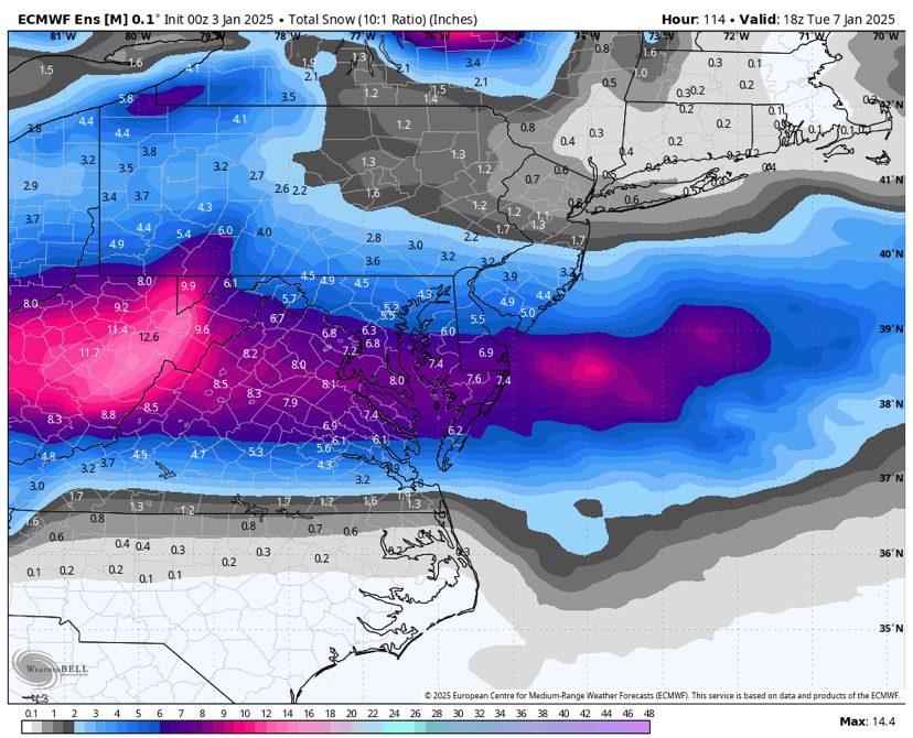
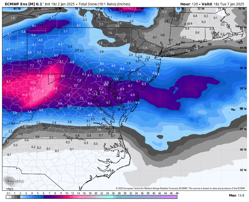
Euro ens. 0z top 18z bottom. Includes .5-1” from tomorrow in the northern areas.
-
Shit, I’d take the gfs over the euro
-
Euro is straight-up paltry north of Baltimore. 4.6” imby, and an inch of that is from tomorrow.
-
And I bet half of that on the M/D line is from tomorrow
-
I know we are closing in on this event, but I’m curious to see what gfs ens show. 18z gefs had some real stinkers that looked a lot like 0z op honestly.
-
I’m not trying to argue - my point is it also juiced up tomorrow’s thing. The map is a little misleading.
-
Some of the increase in the northern areas is from tomorrow. Almost 1.5 from that (lol)


