

HVSnowLover
-
Posts
2,952 -
Joined
-
Last visited
Content Type
Profiles
Blogs
Forums
American Weather
Media Demo
Store
Gallery
Posts posted by HVSnowLover
-
-
1 minute ago, wdrag said:
Please keep us posted on webcam at 7PM and 9P. After that's for sure all rain til maybe 10A Sunday when its too late.
Haven't see PHL and BWI reports but my guess at least 0.1" there---just via sleet.
Not sure it will be all rain 9 pm to 10 am. I think maybe central park on north could see some mixing back and forth but definitely no accumulation after 9:00 pm.
-
2 minutes ago, MJO812 said:
Latest HRRR has accumulations from northern NYC and North shore of LI.
Pretty much expected Northern NYC and probably north shore of LI should at least get something although a total blanking or white rain wouldn't be shocking either, all depends on intensity of precip onset imo.
-
 3
3
-
-
-
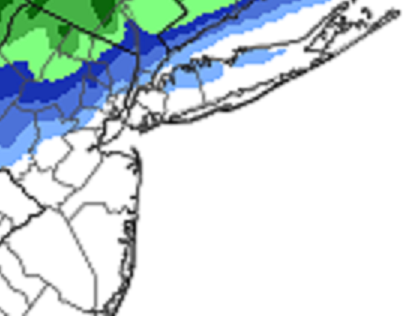
Not surprisingly it looks like the freezing line right now is the I287 corridor.
Temps in the city right now ranging from 38 at the rockaways to 34 north Bronx.
-
1
-
-
5 minutes ago, SnowGoose69 said:
That makes more sense...the HREF yesterday and many forecasts in prior days I said were way too snowy in places like NE NJ near TEB/cntrl Westchester and near interior SW CT. I never bought places like Paramus, Valhalla, areas along 15 seeing like 7-8 inches at all from this. Those places getting totals like that and NYC seeing nothing usually only occurs in setups like those bastardized miller Bs where you have low level S-SE flow that is weak and penetrates the coast immediately but not inland or where you have a really marginal air mass ahead of the storm with again light e-se flow and you're like 40/31 at the coast and 37/27 up there when it starts...maybe like a 1/6/02 or 1/3/03...seeing that gradient in this sort of event would be unusual...it would typically be 25 miles more N as is shown now
Yes haven't had an I95 gradient storm in a while. It's usually always I287 now or even I84 although this could still be 2 inches Riverdale, 4 inches at HPN, and 0 at CPK which is more of a difference than most recent storms I can remember.
-
15 minutes ago, donsutherland1 said:
Latest HREF:
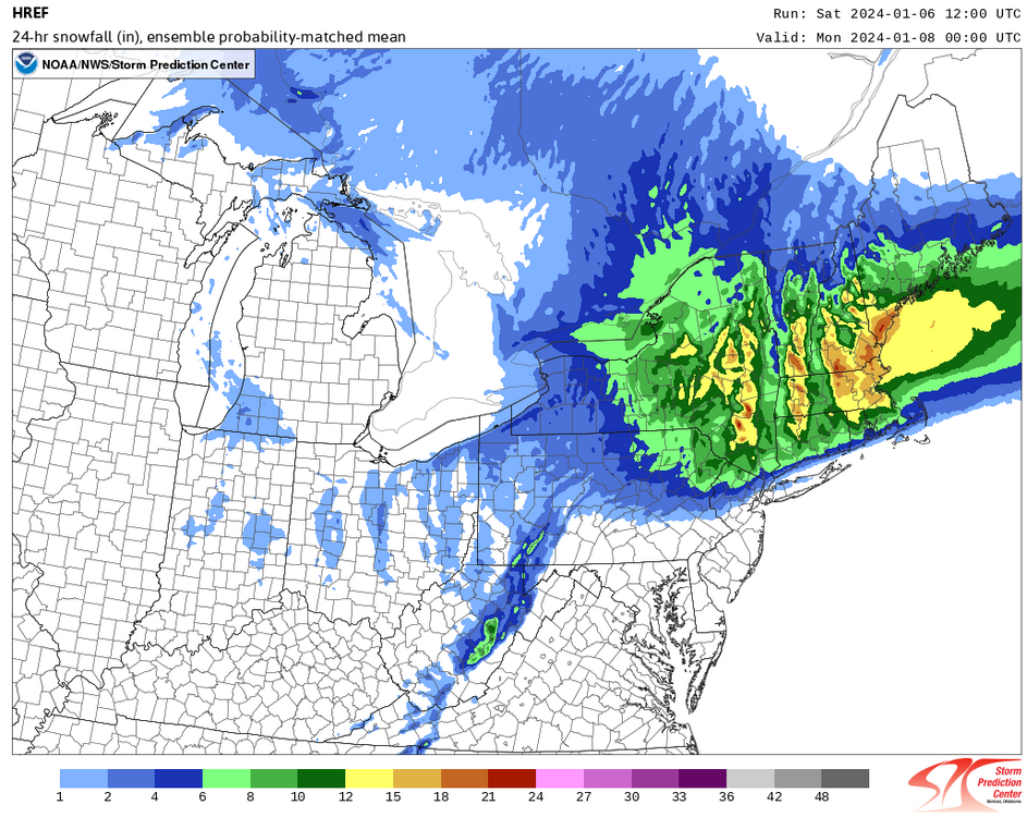
The 1" line appears to be near the border of Manhattan and the Bronx, but north of Central Park:
The 2 inch line looks like it goes into the NW corner of the Bronx. There does seem to be a tight NW to SE gradient for sure.
-
1
-
-
2 minutes ago, psv88 said:
34/26 here, wetbulb of 31. Still expecting a sloppy coating, but wouldn’t be shocked to get nothing
How do you determine the wet bulb temperature?
-
The cloud cover certainly can’t hurt in terms of holding temps down. 33 right now, probably needs to realistically be 35 or lower with heavy precip onset for any accumulating snow.
-
1 minute ago, Tatamy said:
Snow is getting ready to move into the Reading, PA area. It never ceases to amaze me how fast these WAA snows move in. I was figuring a 1PM start here in the Lehigh Valley however at this rate I think it will start by noon.
Do we know what is actually hitting the ground vs virga? It still says doing nothing in Philly.
-
39 minutes ago, BoulderWX said:
Storm moving in early? I’m heading to the poconos at 1 and looks like they’re already getting some good returns in PA
That would help a bit I think if precip arrived earlier than expected. That’s actually probably the only real hope SE of I287.
-
Taking the advice of minimal expectations. Expect nothing here but white rain to plain rain. Anything else will exceed expectations at this point.
-
1
-
-
The NAM/HRRR actually look decent down to Northern NYC but I'm sure the RGEM will slam any hopes.
-
NAM I'd say is a tiny bit colder/snowier this run especially for the zone between 95 and 287.
Also has the backend snow that I'm very skeptical of.
-
15 minutes ago, Allsnow said:
No

Well there is a sharp cutoff between mostly rain and mostly snow falling but the big totals still seem way NW of NYC.
-
3 minutes ago, MJO812 said:
Euro is so close to mostly snow for NYC. It's a hair south.
What a cutoff
Map?
-
16 minutes ago, LibertyBell said:
I'm not either but I want him to do it anyway haha
I’m not going to do it but I’ve literally considered going somewhere to storm chase and sleeping in a car.
-
2
-
-
19 minutes ago, SnowGoose69 said:
Not really....I think the Newark/NYC/LGA area does have a shot for something here but you probably need to see this come in 2-3 hours ahead of what most models have now. That is an area that could if everything went right probably see like 2-3 inches.
If it came in 7 am instead of 7 pm this is likely accumulating snow for everyone but it is what it is.
-
22 minutes ago, justinj said:
Does anyone think this coast has atleast a shot at an inch? Seems very unfavorable
Depends how you define coast?
-
8 minutes ago, LibertyBell said:
There's a nice park up there, you can stand there and measure the snow for us and live post about it every hour.
I'm probably less convinced than you that they'll be much snow falling in that park for more than a few hours.
-
1
-
-
18 minutes ago, vegan_edible said:
so i gotta drive from the west village back to wp around 9ish tomorrow night...
in my 03' corolla
how screwed am i
Likely fine, definitely fine from the west village to the central Bronx. North of there iffy but highways probably be wet, maybe slushy north of the Cross County.
-
2 minutes ago, MJO812 said:
I will be in the Bronx tomorrow so hoping to see some snow lol
Probably need to be in the Bronx after 7 pm as I think that's the approximate start time?
-
1 minute ago, wilsonvoid1 said:
Wrong. it's west and a bit colder
.I'm talking about the initial surge. The second wave I guess we'll see if anything actually pans out with that.
-
GFS about the same. Maybe a touch north and warmer.
-
1 minute ago, cleetussnow said:
At my location for of HPN, I am rooting for:
1) Heavy front end saturday/saturday night
2) Dry slot instead of rain
3) Sunday developer snow
That's the ONLY way we get to accumulation OTG more than a 3 sloppy inches here IMO.
And I don't think there is a single model depiction that shows that exact scenario, but I am also not tracking every single run all day long so maybe there is.
I think you can get 3 inches OTG without number 3 as long as 1 and 2 happen . I think 3 is going to be nuisance snow.


Two Mdt to high impact events NYC subforum; wknd Jan 6-7 Incl OBS, and mid week Jan 9-10 (incl OBS). Total water equiv by 00z/11 general 2", possibly 6" includes snow-ice mainly interior. RVR flood potential increases Jan 10 and beyond. Damaging wind.
in New York City Metro
Posted
This seems to be the best case scenario with the precip coming in early although seems NYC itself (particularly the northern parts) are fighting some dry air issues.