

HVSnowLover
-
Posts
2,952 -
Joined
-
Last visited
Content Type
Profiles
Blogs
Forums
American Weather
Media Demo
Store
Gallery
Posts posted by HVSnowLover
-
-
6 minutes ago, allgame830 said:
Fair enough…. But it’s still 6-12+ area wide
Yea I'm still not overly worried about surpression especially for anyone SE of Orange county but can't say it's not at least a possibility.
-
1 minute ago, weatherpruf said:
Don't know what people are worried about or how good that depiction is, but that's as good a look as you're gonna get. But doesn't mean it will happen.
Verbatim yes it's a great look. The worry is it trends toward the Euro. I'm not that worried at this point though.
-
1 minute ago, TJW014 said:

That might be an indicator the south tick is legit since I believe HRRR had been one of the more NW models?
-
7 minutes ago, mob1 said:
We're also losing dynamics with each successive run. A deamplified storm may be good for our location in terms of snow in general, but you're losing good rates and dynamic cooling in an already questionable airmass. You're essentially trading a formidable snowstorm for northern areas for a slop fest in our backyards.
Yea basically. Don't really like the trends at all but again there might be too much Euro hugging on here. Most other models still have the best dynamics right over the metro and the best snows still just NW of the city.
-
 1
1
-
-
Whether it sticks or not depends on rates. If it's heavy the temp will drop and it'll paste everywhere. If it's light it'll be white rain. It's most important to be in the best dynamics.
-
Just now, USCG RS said:
I agree, however, the Ukie and Euro tend to follow each other. Downstream observations show a significant amount of juice with this storm. I would not completely discount, but, I would also say just keep in mind and watch Short Rangers currently. If they begin to back up the Euro, then I would put true stock in it.
Would be amazing if after all this time this misses to the south and hammers Coastal NJ while NYC see's light white rain. I just don't see it happening though but have to keep on eye on this trend.
-
 1
1
-
-
3 minutes ago, Brian5671 said:
I agree but the UKMET is also mostly a non event. I worry when it's a couple models not on board. However it's 2 globals and we are under 24 hrs
Aren't globals less reliable than mesos at this range? Also the Euro has definitely busted cold/south before. I'm not saying it's not a possibility but it seems extreme. It's crazy that less than 24 hours out we have such model disagreement.
-
If the Euro is right a lot of forecasts will bust badly especially for northern zones. I think the Euro is too far south though when comparing it to all the other models.
-
2
-
-
5 minutes ago, MJO812 said:
Hrdps
Cut some but still a nice storm


The north shore of LI up into SNE could get really rocked as this bombs out.
-
1
-
-
6 minutes ago, psv88 said:
And the mesos all show warning snows for Nassau and Suffolk, even with kuchera. I think they have to go with a watch at the 4 am advisory
Given what Upton is forecasting in their high end totals it's still hard for me to see them jumping to a WSW but i guess we'll find out. Right now they don't even have places just NW like NE NJ, Southern Westchester, CT Coast under anything so they seem to be going really conservative.
-
1 minute ago, SnowGoose69 said:
I think Upton/Mt Holly might still be cautious, even if the Euro drops more S....might see them go like 2-4 or 3-5 in NYC for the time being or along that general latitude
I think if 0Z Euro looks like the other models NYC will be under a WWA by the morning.
-
1010 wins calling for up to an inch in the city. If the latest models are right they'll be way off....
-
1
-
-
3 minutes ago, qg_omega said:
Kinda shocked how strong the storm is modeled, if that’s true many will flip to snow but no storm this year has been that strong
If the low stays south of ACY and is that strong it will snow for most of the subforum. We'll see.
-
4
-
-
2 minutes ago, LongBeachSurfFreak said:
Not with a crap airmass. You need it to pound to scour out the urban heat island. This is going to come down to rates or you’re going to waste allot of snow. Outside the city and the immediate coast, not as big a concern.
The airmass is one concern but could be overcome with the right track and dynamics, to me the bigger concern is if we get a late north tick in the track of the primary.
-
1
-
-
3 minutes ago, MJO812 said:
I understand if it was just one model but every model and ensembles?
Yes there could still be a tick in either direction another 30-50 miles since we are still over 24 hours out. Unfortunately it's usually a late tick north with these. I'd want to be 30+ miles north of where the models have the gradient now to feel too comfortable.
-
1
-
-
Is December 19 2008 a good analog for this storm? I know we live in a warmer world now.
-
Just now, MJO812 said:
Jeez

Verbatim it's starting to look really promising especially for northern NYC/northern LI but we've seen this song and dance so many times and I am fearful of the typical north bump at the last minute.
-
2
-
-
1 hour ago, EastonSN+ said:
Seems they expect it to bump back north a little tomorrow and the gradient to be around I287 as opposed to the models pulling it down to I80 today. Unfortunately they may be right
-
1
-
-
18z GFS is south of it's previous run for sure.
-
1
-
-
The warm biased RGEM showing big snows into parts of the city is a flag this may be the real deal but it's also a very close call as the gradient just south of the city is very sharp.

-
Barring another north shift (definitely possible) this is probably the most significant snowfall SE of I287 in 2 years. Strong off shore low, no mid and upper level temp problems. The only issue is surface but that could be overcome with good rates.
-
35 minutes ago, mikem81 said:
ERUO just shifted 30-50 miles south or so... One more of those and NYC is in the game, but that is a big ask
The euro is enough to put I80 through the immediate northern suburbs in the game. NYC would need a bit of a tick south but the bigger question is this a wobble or a trend?
-
7 minutes ago, jm1220 said:
Tougher call for the N Shore, Northern NYC and I-80 in NJ, slight south shifts can bring them in the game for 3-6”. But I-84 corridor looks golden for this and has for days.
Agree it does look trickier for the above region than I initially thought. The gradient should be somewhere near I80 latitude and then ENE of there if the current track holds.
-
This actually could be a JFK 1 inch, HPN 6 inch type storm. The upper levels are fine so the small differences in surface immediate coast vs just inland could make a difference.


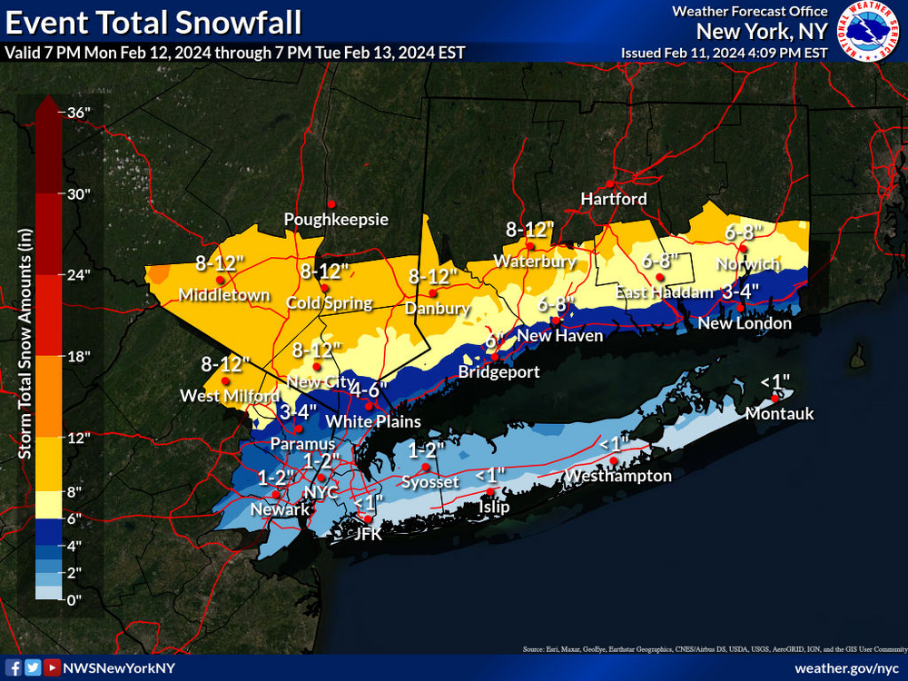
2/13 Significant/Major Winter Storm Discussion & Observations
in New York City Metro
Posted
The south trend is making 12+ amounts anywhere unlikely. I think the high end is probably 8-10 for the jackpot area which would still be a really nice storm.