NCSNOW
-
Posts
4,430 -
Joined
-
Last visited
Content Type
Profiles
Blogs
Forums
American Weather
Media Demo
Store
Gallery
Posts posted by NCSNOW
-
-
Avg last killing frost here is April 20th. Still over 2 months away. Hard to beleive with the current temps.
-
We might get lucky and score a late season early spring storm. Theres always a chance. But for this ole boy its time for me to stick a fork in winter 17/18. Wasnt all that bad. BN Nov,Dec,Jan. 8 straight days below freezing, and ended up a tick above climo for annual snowfall.
Yall have fun chasing severe wx, mosqituoes and a shady spot the next 9 months. I'm airborne and headed toward the bottom of the cliff.
-
 4
4
-
-
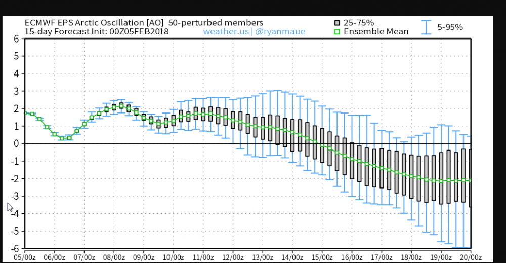
You want be getting a early spring while the AO tanks to -3 and hangs out.
Doesnt gurantee a snowstorm eatheir.
-
1
-
-
Eps is sending AO in the tank second half Feb
-
3
-
-
25 minutes ago, burrel2 said:
lol, I'm just joking of course. But it does look bleak for the next 2 weeks. But there's always March 1960!
I gotcha. It would be cool though
-
1 hour ago, burrel2 said:
See you guys next winter

Lol . Once you check out of the hotel that's it , no coming back. Have a safe and happy summer.
We seriously ought to start a thread. Title it the "checkout thread".
That way folks can put their money where their mouth is. Rule is once you declare winter is over then you post all you want in that thread but aren't allowed back in the mid to long term thread until after March 1 or 21st end of met or winter solistice.
-
1
-
 1
1
-
-
Seeing some encouraging signs on models. Feel more optimistic than I have the past couple of days well get at least one more 7 to 10- 14 day window of opportunity to have a legit shot or 2 to rope one in. This pattern is still fast and NS dominant so that's a handicap, but we've made it work for us a few times already this winter.
-
2
-
-
This is what we want to see. Webber says jma is more reliable forecasting the MJO entering phase 8 compared to euro and gfs. MJO is webber wheelhouse so it's encouraging to see it advertising this
-
37 minutes ago, tramadoc said:
Once again, punt one to two weeks longer. That seems to never change.
To be fair, everyone has been post 2/7. So we will see if after a week from now how things shake out. This 1st week stuff is just and added bonus, most of the thoughts Ive read from JB,Robert and webber etc where never touting the 1st week of Feb.
-
1
-
-
24 minutes ago, Cold Rain said:
Fab Feb quickly turning into February Flameout. Give it a couple more days and the MJO is going to be shown going back into Phase 6.
Yea the waiter(MJO) who's supose to deliver the main course dish is making moves sugesting he may be turning around and heading back to the kitchen before reaching our table and serving up the goods. Referncing mjo going into cod in phase 7 or worse back toward 6 like you alluded to. Lets all hope thats not the case and just some noise/false move.
-
1
-
-
8 minutes ago, mackerel_sky said:
And no storms or very cold air on 6z GFS long range!? Here we are a day away from Fab Feb start, and it ain't looking too Fab, anytime soon
Gonna be hard to top the Jamming December & January places like Wofford and Clemson SC have had!
-
I'm all in for Monday now. Canadian been beating the drum for a while and icon with its high res right there with it.
-
1
-
-
2 minutes ago, Queencitywx said:
Looking at the canadian, I'd say best chances for warning criteria snow would be in the foothills and across Tennessee but it isnt far off.
Canadian has been on those for like the past 4 cycles now. As Ward said back in Dec , when you have a model locked in run after run you need to pay attn. He was referncing Navgem back then and it turned out to be correct beleive it or not.
And great point about pre season kick in the gut forecast for this winter. Thats what makes it all the more enjoyable.
-
1
-
-
6 minutes ago, POWERSTROKE said:
Plenty more plowing will be done. Even got to put a little salt out this morning. Winter is far from over as February looks good from most all forecasters
Indeed it does. Solid half inch up here near the airport this morning. Ground still white in the shade. January turned out to be a great month. Looking highly likely RDU may go wall to wall cold this winter. Below Normal Nov,Dec,Jan. February looks like it may end up greatest departure BN. Well see.
Also alot of us,minus SC interior folks are above normal anual snowfall. I'll be shocked by Feb 28 if we haven't had not 1 but atleast 2 good winter storms here in the Triad over the course of Feb.
-
2
-
-
0z Cmc is a nice hit Monday in NC. Gfs is close. Difference is GFS has lp inland and cmc offshore which gives northern and western NC a colder profile. More is on the heels of Monday so plenty of shots coming up. Right now it's Monday event that is track worthy imo. Canadian has been pretty consistent with it and gfs to a degree.
-
1
-
-
1 hour ago, griteater said:
12z CMC has some wintry precip in western NC next Sat night into Sunday, then has 2 additional weak systems that are close calls for wintry precip on the following Mon and Wed
Cmc had this at 0z last night as well. Thanks for 12z update.
Man has it turned cold outside. Still think northern coastal plain can luck up with a trash can lid topper tonight.
-
1
-
-
Quick glance 0z. Canadian had snow in western NC over to triad next Sat. Changes to rain. Miller Bish looking deal. Mtns had a few hits, rain to snow, vice versa, no biggies on icon and gfs. Check the ukie and euro in the a.m.
Didn't bother looking past 6 days
-
Hazardous Weather Outlook
Hazardous Weather Outlook
National Weather Service Raleigh NC
314 AM EST Sat Jan 27 2018

NCZ007>011-024>028-041>043-078-281030-
Person-Granville-Vance-Warren-Halifax-Orange-Durham-Franklin-Nash-
Edgecombe-Wake-Johnston-Wilson-Wayne-
314 AM EST Sat Jan 27 2018

This Hazardous Weather Outlook is for central North Carolina.

.DAY ONE...Today and Tonight.

Hazardous weather is not expected at this time.

.DAYS TWO THROUGH SEVEN...Sunday through Friday.

There is a slight chance of wintry weather late Monday night into
Tuesday morning from the Triangle area to the north and east.

.SPOTTER INFORMATION STATEMENT...

Spotter activation is not expected at this time.

$$
-
If you got snow from the December event, Then Id suggest watching next Friday into Sat. Same areas are candidates, espeacilly mtns, to really luck up here. Noticed the GEM pics in the MTN thread comparing last 2 model runs how its not far off from Northern GA, mainly NW GA getting in on some action. Grain of salt and caution cause im just looking at surface and not H5 maps. But this sould get interesting.
-
54 minutes ago, AsheCounty48 said:
This...this could work. Midday runs are good for about half of North Carolina.
Yes they are. Week away but its starting to catch my eye. Id be getting a hair tick excited espeacilly up your way if these trends keep up over the weekend. Boderline as it gets imby, but not out of the question some folks in NW NC outside of the mtns can't score frozen. Ill officially start tracking Sunday if its still hanging around on models.
-
1
-
-
Rather talk about the GFS calling out the Triad members saying "Come on Over to the Mack/Shettley side" and see what its like to chase a one week threat from the borderline to nada!

-
2
-
1
-
-
39 minutes ago, mackerel_sky said:
That look in Grits post has a Rockies trough look, which won't do anybody well in the SE that wants cold and snow! Also, gonna have to get pretty cold air to get wintry precip, 10 degrees BN, puts me at 45 ish for a high! Hard to get wintry with that! Need some 20-30 BN temps to score IMBY!
10 below at the surface on a sunny day isnt what you need to look for. How bout 2 to 5 BN at 850 when a storm is winding up. Then youll get your 20 BN at the surface thanks to frozen precip falling into wedged CAD
-
4
-
 1
1
-
-
Hope everyone has enjoyed their thaw/break. Cause February is getting ready to write the exclamation point on one of the top 5 all time winters in the SE. Ill be very suprised with what Im seeing and reading if the winter of 2017/2018 doesnt go out with a grand finally "Glory Style."
-
4
-
-
Unreal but true. Saw this on JB twitter feed.

-
6
-

2018 Banter Thread
in Southeastern States
Posted
RIP: Billy Graham
What a vessel and what an impact he had on this world. Still love listening to his sermons on YouTube.