NCSNOW
-
Posts
4,430 -
Joined
-
Last visited
Content Type
Profiles
Blogs
Forums
American Weather
Media Demo
Store
Gallery
Posts posted by NCSNOW
-
-
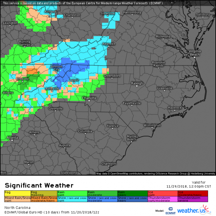
12z Euro stays frozen from 8pm Fri Night till 4-5 a.m. Sat morning in Boone.
-
 2
2
-
-
Saw this in the other thread, appears quick thump up snow isnt out of the question before change to ice, then rain.
-
1
-
-
36 minutes ago, BooneWX said:
For those of us attending Saturday's matchup in Boone: 12z Euro and GFS both agree that heavy precip rolls out around 12 pm. Fingers crossed....
Lets hope. Win and we have a better than average shot at a snow bowl the following Saturday for the SBC Championship. Gotta win 1st.
-
1
-
-
1 hour ago, strongwxnc said:
Headed to Boone that morning. Normally I’m all in, but i need to get up to Boone around 7 and home afterwards
.You me and 25,000 plus other folks. HUGE GAME. Not liking the trends. Rays wx says rain winds down by noon after mix fri night. High near 50 Sat. But I have my doubts along with NWS forecast discussion. Worried about our guys, not fans like myself, being able to run our stuff without the weather dictating it. Cad will be locked in Fri Night.
-
-
28 minutes ago, Hvward said:
I am excited to share with everyone that after some hard work/learning, I have finally gotten a downtown Asheville webcam up and running on my site. Hope you guys check it out!
http://www.ashevillewx.com/gtadowntownashevillecam
Awesome. Is that facing west? Now go set one up at Joe and Bucketheads house and well be in business.
-
3
-
-
Add Boone to the flake list. Congrats,maybe a trash can lid topper tonight.
-
1
-
-
Coming down pretty hard on top of sugar . Hopefully itll get down some of yalls neighborhood here soon
Even the ice skating cam looks pretty impressive
-
Dewpoint down to 30 at Greensboro, was 32 couple hours ago. Still sitting at 28 Martinsville. Even though we have February sun angle, havent had the time to entrench the single digit ,-0 dry arctic air over NE. Which is where the Cad HP is sending us air from. 3 weeks from now its a different story
-
3
-
-
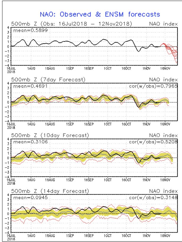
Always think of the nao as the trap door, keeps cold locked in. The pna is the driver,spikes up and forces cold air down. So if your neutral to slightly pos and the nao is tanking. Then you can get air to come down and stay around for a while. Actually we should do well with the forecasted indicies.
-
8
-
-
Dewpoint is 28 in Martinsville, 33 in Greensboro. See 8f we can get it to crash down a few more ticks today before moisture arives. Wetbulb is safely above 32 for time being.
-
5 minutes ago, Poimen said:
You have to love this look as we head towards December:

"I'm dreaming of a white Christmas, just like the ones we've NEVER KNOWN, (except that one time)"
-
3
-
 5
5
-
-
You talk about perfect riming. Radiational cooling got maximizwd last night and cloud deck rolled in right before sunrise. So many times we track events and have to monitor this scenerio the eve of an event. Usually dont see it wirk out like it did this morning. Want matter in grand scheme of things.
-
7 hours ago, donsutherland1 said:
During the November 12-13 period, parts of the Southeast will likely pick up 1"-3" of rain. In the wake of the storm, 2018 will likely become among the 30 wettest years on record in a number of cities in Georgia, South Carolina, and North Carolina. Wilmington, NC, which has already picked up a record 90.65" precipitation this year will add to its record.
Below is year-to-date precipitation, the current rank for 2018, and scenarios for the ranking based on 1"-3" rainfall.
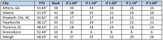
Records in the above cities begin as follows:
Athens: 1857
Atlanta: 1878
Elizabeth City: 1934
Fayetteville: 1910
Florence: 1948
Greensboro: 1903
Raleigh: 1887Thanks for this info. pretty impressive
-
1
-
-
Cant beleive no ones posted the 120 hr clown map off gfs
-
7 hours ago, BornAgain13 said:
Pictures?
It was storm warning amounts. Up to 1.0 on forsyth yadkin line back toward wilkesboro, and alot of.5+ as well in the red areas on NCHailstorm precip type map. Long ways to go with this one. Euro does a trailing wave after cold gets locked in thanks to cad.
-
54 minutes ago, Hvward said:
Looks like a two wave ordeal per the Euro. First wave sets the stage with a 50/50 low and then the second wave moves in Thursday am from the Gulf. The two wave setup is the way Asheville will get anything more than a dusting from the pattern.
Thats a nice size ice storm all of NW NC down the foothills 77 coridor in NC
-
ICE STORM on the euro from Triad all the way back to the blue ridge . Wed into Thirs
-
See if I can help yall out:
![[âIMG]](https://www.tropicaltidbits.com/analysis/models/gem/2018110812/gem_asnow_seus_27.png)
-
1
-
-
Beat goes on from last night: Ski slopes ought to be licking their chops about an early start.

-
4
-
-
We need to get eyewall to take his drone up to Sugar /Beech middle next week.
-
4
-
-
13 minutes ago, Upstate Tiger said:
Surprised early next week is not generating a little more discussion. At least fun to have something to keep an eye on before Thanksgiving! In these parts that's a rare thing....
I've tried to pull the alarm bell this thread and mtn thread. Although they've caught on and are just patiently hanging back to avoid a Lucy Pull the ball. Impressive pattern coming for this early in the season. Without a doubt the slopes have the opportunity to get a jump on the ski season
-
Thats Vodka Cold,Not just cold coming down next week on the Euro. Sub 40 highs with full sun in mid November is impressive.
-
3
-
 1
1
-
-
1 hour ago, griteater said:
The November Euro for Dec-Feb, Dec, Jan, and Feb (500mb maps)...


Ill write a check for this and cash out right now.
-
2
-

2018/2019 Mountains and Foothills Fall/Winter Thread
in Southeastern States
Posted
Didn't want jinx by mentioning. That's what I'm way more concerned with. Hopefully it holds and regardless if its Rain Sleet Snow or Shine, Me and my crowd will be there.