NCSNOW
-
Posts
4,430 -
Joined
-
Last visited
Content Type
Profiles
Blogs
Forums
American Weather
Media Demo
Store
Gallery
Posts posted by NCSNOW
-
-
Amazing giving the warmth on my way to work up i85 this morning, the deep river is still frozen loaded with ice on top.
It's been that way the entire month of January.
-
JB all over the hammer coming down FEB. He's making a great case. HAve to agree with him. RDU will have BN Nov,Dec,Jan in the bag. Can they score the royal flush and get Feb BN and score 1 more storm? Winter would go down as one of the all time greats for coming as close as you can wall to wall cold and above seasonal avg snowfall. Trick is first few days of Feb not going insane AN. You only have 28 days, but their avg daily highs start creeping up so it's easier to get much BN temps.
Loving riding around and seeing white everywhere. Anyone wishing for a short thaw is crazy. Your gonna get 6+ months of all the thawing you want 90 over 70 DP style before long.
-
 4
4
-
-
FV3 will replace GFS by 2019. They wI'll still call it the GFS. Not sure why you want to keep that name tag unless you want to keep low expectations.
-
That Euro late run if correct would be yanking down some serious Cold after that lp runs up to our west. Real curious to see how Feb shakes out. Been a stellar winter for all of us. Id like to see the stj come to life . Its been dormant all winter, but if we could get one more cold press and get it involved as the season winds down then there would be some serious fireworks
-
3
-
-
3 hours ago, FallsLake said:
This could work:

This will work Better: Your future GFS I beleive
-
2
-
-
7 hours ago, WarmNose said:
Time to break out the sunscreen. At least the wedge gives us a fighting chance at staying BN for the month

It is a locked gurantee RDU and every other town in NC ends up BN for January. It can run 10 above normal the last 10 days of the month and it's still a slam dunk BN month.
Currently Jan is is in the top 2 all time coldest on record for RDU to put things in perspective
-
1
-
-
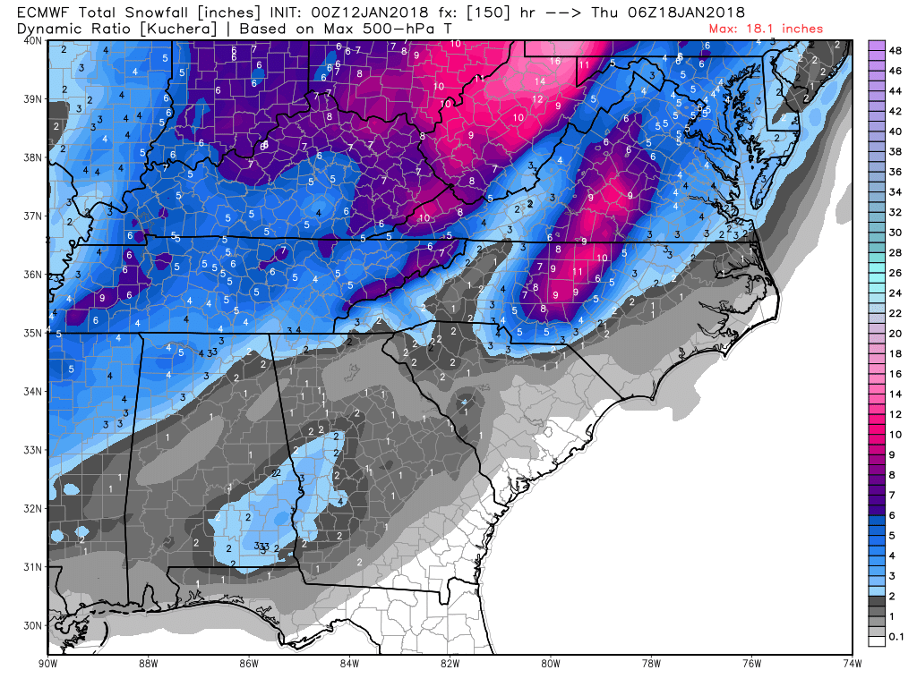
5 minutes ago, Queencitywx said:
Max this run is dead center in Guilford County, probably close to 9 or 10.
Bout where the kuchera had the oz max right at 9-11 inches. 15 to 1 ratios areso much more funner than our standard 8 or 10 to1
-
1 hour ago, Red1976Red said:
Joe Bastardi@BigJoeBastardi
32 minutes ago
Said Wednesday I like looks of southern and eastern threat next week, May snow somewhere on the gulf coast for the 3rd time this winter Pattern with max coming thru Ohio valley big deal. Posting on http://weatherbell.com right now
The winter of 2017/2018 already has made some great history from a winter lovers perspective across the SE. Saw a post reading through everything and I dont want to rehash/document all the events up until this point. I just want to call attention to the increasing possibility that this winter could end up being one we reference back to for years to come. All we need is 1 to 2 more decent hits in the right spot and just about everyone on this board will end up above to much above normal climo wise for snowfall. Couple that with the cold(guranteed BN for RDU (Nov,Dec,Jan) we start getting into the wowza territory. Im rooting for FEB and March to end up BN. I would never in my lifetime thought Id see RDU run BN Nov-March no matter what the pattern. Just food for thought and definitely putting the cart before the hoarse here, but its doable no doubt.
-
 1
1
-
-
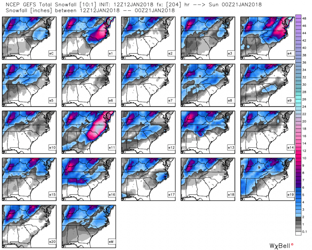
E11 for the win:
-
6
-
-
1 hour ago, NC_hailstorm said:
Shortwave is trending slower(blocking) and digging more southwest.
More people have a chance if that trend continues.
Agree, those are the trends to root for H5. Also should be some killer ratios with this event, so keep that in mind, not out of the question to get 15 to 1 or better espeacilly north of i 40. Just need it to keep digging on future runs and we should all be happy by this time next week. .25qpf with 15 to 1 ratios is 4 inches. Not to hard or extreme a scenerio to root for.
-
-
52 minutes ago, mrdaddyman said:
The Euro has shown a threat for this time period for several runs now (~4). Hoping it has legs.
Yep and Its not exactly where we need it to be right now but seeing some things that could really work out for several people on this board. Could get real interesting by late this weekend into next week if tracking a threat is your cup of tea.
-
1
-
-
1 minute ago, mackerel_sky said:
Short answer: No
Hows it gonna snow with all those pretty orange maps you've been showing!? But our best storms come after a warm day or two!
Need this thing to close off 100 miles futher east of the Mississippi. But agree this has big potential for mtns. At a minimum on backside they'll still score several inches
-
3
-
-
43 minutes ago, mackerel_sky said:
JB says, a few days of thaw, then back to cold, then " drop the hammer cold" !
We've already had a great winter imo, if it ends tommorrow. Complete reversal from past 2. That being said this winter if it chooses to, can paste bomb us a couple of times and go down in SE weather folklore beside 2009/2010 as one of the best ever. Already has a historic cold snap and historic coastal GA and Carolina snowstorm (Blizzard) NE NC and tidewatwater. I'm interested to see how the second half shakes out. Encouraged the thaw is transient and right back to winter by Saturday.
-
3
-
-
39 minutes ago, mackerel_sky said:
GFS has a cold look after this Friday storm also
Fact or Fiction. Hope it's right. Cmc seems to agree.
-
1 hour ago, mrdaddyman said:
This is a pretty good read for the upcoming pattern if you are interested:
Awesome Read. Thanks for sharing
-
1
-
-
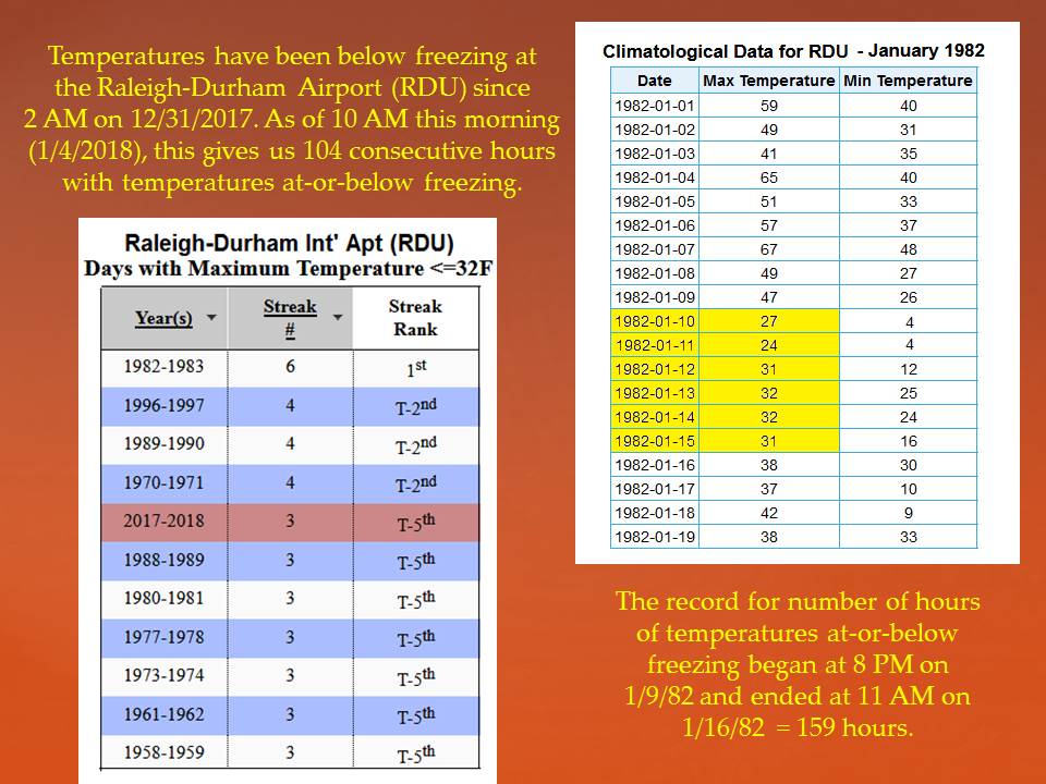
Saw this on Rays for the MTn folk. Really Historic Cold Snap we are having in these parts. Want get the all time record lows, but the duration is something to behold. Raleigh set to break consecutive day streak below freezing). Heres one for Boone
Memorable Cold Stretch
 We are in the midst of a memorable cold stretch. We only had time to run these numbers for Boone, but historically, these are the longest span of consecutive days with high temperatures less than or equal to 20° (the respective highs in parenthesis):
January 17-21, 1977 (9, 12, 10, 20, 16)
January 3-6, 2010 (16, 17, 16, 17)
December 22-25, 1989 (16, 11, 18, 19)
January 23-25, 2014 (20, 19, 20)
February 4-6, 1996 (11, 3, 20)
December 24-26, 1995 (19, 17, 20)
February 17-19, 1958 (5, 8, 16)
Today will be 2 days in a row at or below 20. We think Saturday will make 3. That puts us in relatively rare territory. Snow showers and flurries continue today. Windy conditions end Saturday morning. Bitter cold lasts through Sunday morning. Clouds increase late Sunday. A wintry mix changing to rain is expected Monday.
As a Cold weather fan gonna enjoy it before the pattern changes and the Flame throwers come out in full force! LOL
-
4
-
-
15 minutes ago, FallsLake said:
Something else that is of interest to me is if we can end January below normal. In years past I've seen the SE CAD areas be able to stay closer to normal as a large area of the US torch. Instead of blazing SW or west winds, numerous CADs develop keeping this zone closer to normal. Nothing cold enough for frozen but cooler never the less.
Below is the first example (NAM) for this upcoming Monday. looking at the GFS it would have 3 or 4 weak CAD events through the LR.

It would take a heat wave like never seen before in Janary for RDU to end up above normal. By Monday Jan 7 RDU will be like 19 to 20 below normal with the month 1/4 complete. Pattern will warm up to normal, but no way to salvage JAN ending up AN. You can go ahead chalk 3 consecutive months BN for RDU. Feels historic to be typing such facts.
Biggest growing concern is precip as we get ready to start second half of winter. Drought breads heat/ remember that this summer. Need rain fall to pick back up
RDU hasn't been above freezing since last year!
-
1
-
-
Shout to WxSouth (Robert) seasonal outlook back in November.
-
Raleigh hasnt been above freezing since last year. Getting ready /on pace to break the all time record for cold stretch: All that LR torchmas talk really went to pots. RDU will have 3 consecutive BN months Nov,Dec,Jan by the end of this month.
-
2
-
-
Enjoyed tracking this last event. Now it's time for leg 2 of the Triple Crown lol. Only 4 1/2 days out. Potential for big Ice storm way it's looking.
We are having an awesome winter, hopefully it can keep it up.
After being BN Nov and Dec. RDU is -20 BN so far this young month. Also they will/should have eclipsed atleast 50% of their annual snowfall avg. Multiple locations across the SE are 200-300 % AN annual snowfall.
Thing I'm most interested in checking is the record for how long PTI Greensboro has gone staying below freezing. Missed rising above today and could very well be Sunday,possibly Tuesday depending on late weekend storm before we get above the 32 degree mark. We are going past day 4 I beleive. Very impressive.
-
1
-
-
Gonna be chase time again second half next week. Hopefully this one will work out a little better in the piedmont. Love this pattern .
-
2
-
-
There is a little meso low in ne GA tommorow a.m. and that may be what Hrrr is latching onto. It probably is what will push the changeover line back up against escarpment area. Until it gets by and your back yard gets on backside , the temp profile will be screwed in NC.
Something to keep an eye on and that has to be what the HRRR is sniffing out and explains all of nc and sc outside of the mtns staying rain. Hopefully it's wrong. I'll be holding my breathe.
-
3 minutes ago, DopplerWx said:
**every other short range model's snow maps with 10:1 ratios
There are no rules in this cage match. Come as you are. Rgem says you can't be on top of the mountain if your standing at the bottom of the hill looking up.
-
1
-


Mid to Long Term Discussion 2018
in Southeastern States
Posted
I hear you Orangeburg. My top snowfalls are:
17/ Feb 2004
15/ Jan 2000
15/ March 1993
So since we are breaking records this winter; just once I want to expierence a 2 Footer. Think Frosty had a 19 inch couple years ago. Jburns had 19 on that Feb 2004, Raleigh think had 22 in Jan 2000. So Im not alone in a quest to join the 2 foot club. Not sure anyone was around down east in I beleive spring 1980 they where right at 2 foot mark.