

40/70 Benchmark
-
Posts
78,521 -
Joined
-
Last visited
Content Type
Profiles
Blogs
Forums
American Weather
Media Demo
Store
Gallery
Everything posted by 40/70 Benchmark
-

May obs/discussion thread - Welcome to Severe Season!!
40/70 Benchmark replied to weatherwiz's topic in New England
Yea, I got down to 27.3, but didn't see so much as a trace of frost. -
El Nino 2023-2024
40/70 Benchmark replied to George001's topic in Weather Forecasting and Discussion
I think basin-wide is the most likely outcome for winter. -
El Nino 2023-2024
40/70 Benchmark replied to George001's topic in Weather Forecasting and Discussion
The 2018-2019 to 2019-2020 warm ENSO handed me my as$....those were my worst seasonals....especially the latter. -
May obs/discussion thread - Welcome to Severe Season!!
40/70 Benchmark replied to weatherwiz's topic in New England
27.3 -
I would say "D" for my area and maybe C- up near MHT.
-
El Nino 2023-2024
40/70 Benchmark replied to George001's topic in Weather Forecasting and Discussion
Yes, they were basin-wide with an eastward lean....kind of like what is modeled for this season's el nino. -
El Nino 2023-2024
40/70 Benchmark replied to George001's topic in Weather Forecasting and Discussion
Well, some of that is due to orientation, too.....which is often more important than strength. Years like 2010-2011 and 2020-2021 had an east tilt. -
El Nino 2023-2024
40/70 Benchmark replied to George001's topic in Weather Forecasting and Discussion
Yea, I mentioned that a couple of pages back...I would take my chances with a Jamstec type of outcome. -
El Nino 2023-2024
40/70 Benchmark replied to George001's topic in Weather Forecasting and Discussion
You know, I am honestly toying with the notion of using that relative ONI that Larry referenced last week....essentially ONI -.4....ie 1.5 ONI will equate to a 1.1 adjusted ONI and hence that level of forcing on the atmosphere. On the flip end of the spectrum...this past season illustrated how utterly useless the ONI can be with respect to diagnosing winter, as the RONI had to have been much lower than 1.0. -
El Nino 2023-2024
40/70 Benchmark replied to George001's topic in Weather Forecasting and Discussion
Good stuff....can't wait to sling that boundary southward. -
El Nino 2023-2024
40/70 Benchmark replied to George001's topic in Weather Forecasting and Discussion
Totally agree....this super el nino talk is far premature. I wish the focus of this thread would shift back to more research and less Twitter regurgitation. That is what I like about Raindance....I may not agree with everything he says, but he always has a wealth of information to share about his thought process. That said, this doesn't mean to imply that next winter won't suck again for the northeast....a moderate east-based event would be enough pull that off, so it isn't about a winter bias. -
El Nino 2023-2024
40/70 Benchmark replied to George001's topic in Weather Forecasting and Discussion
As will orientation....an event that remains heavily east based isn't good for anyone. -
El Nino 2023-2024
40/70 Benchmark replied to George001's topic in Weather Forecasting and Discussion
Did you even look at the excerpt that I emboldened? That isn't what I mean and it wasn't what he means, either. Pretty sure he was just sarcastically making the point that models are often initially too aggressive with the warming. -
El Nino 2023-2024
40/70 Benchmark replied to George001's topic in Weather Forecasting and Discussion
Same page.. -
El Nino 2023-2024
40/70 Benchmark replied to George001's topic in Weather Forecasting and Discussion
Even if it ends up being another rough winter, I am just glad this stagnant pattern is finally changing....man, I was sick of la nina. -
El Nino 2023-2024
40/70 Benchmark replied to George001's topic in Weather Forecasting and Discussion
Very true, but there is a correlation between the PDO and ENSO, so ENSO is not entirely moot. However, from about the latitude of Boston points northward, snowfall is more closely correlated to precipitation than temps, anyway. Obviously seasons like this past year are exceptions given the degree of warmth. -
Winter 2022-2023 Promises Plenty of Mid Season Mayhem
40/70 Benchmark replied to 40/70 Benchmark's topic in New England
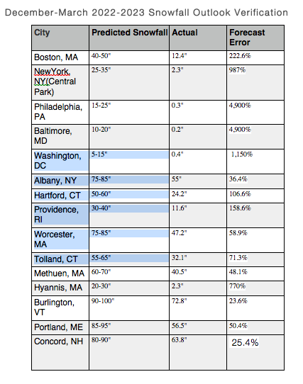
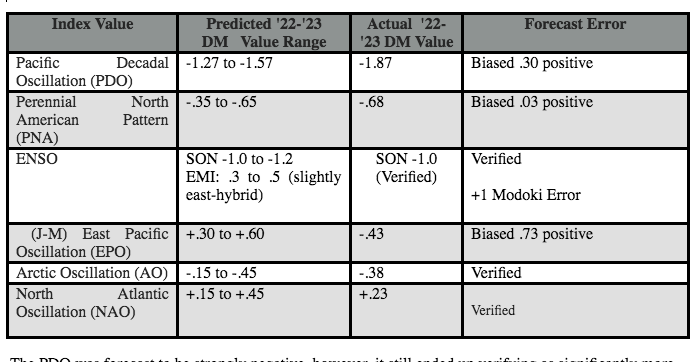
Winter 2022-2023 Seasonal Review & Forecast Verification; Tamer Than Expected Results Bookend Blocking Negated by Near Record Cold Phase of Pacific Month of December Largely Well Forecast December 2022 Review December Analogs: 1970, 1971, 1973, 1975, 1984,1992, 1996, 2005, 2007, 2008, 2013, 2016 The month of December was forecast remarkably well with respect to the Pacific, as a predominately negative phase of the PNA prevailed, which favored cold loading to the west. In fact, the December PDO value of -2.21 was the fourth lowest value for the month of December on record dating back to 1950, only exceeded by December 2021, 1994 and 1990. Thus given the historic nature of the Pacific pattern it is not surprising that precipitation on the west coast was more prolific than the sensible weather composite had indicated for the month of December: Actual: Forecast Composite: This highly anomalous surplus of precipitation on the west coast is of course very reminiscent of the -PNA style extra tropical Pacific pattern, which featured 3/5 primary ENSO analog seasons in 1955-1956, 1970-1971 and 2010-2011, respectively. The one notable difference being its placement over California instead of the PNW, which will be addressed in a moment. It is fair to say that snowfall over southern New England was lighter than anticipated due to the nature of the Pacific pattern, however, in general the forecast narrative for the month of December favoring the deep interior and elevations, as well as northern New England for snowfall was correct given the historic prominence of the cold phase Pacific pattern (-PDO). "The month will gradually turn colder as the high latitudes become more disturbed, and while the mid Atlantic may find snowfall scarce, New England should not...especially north and interior. However, coastal areas/lower terrain may have frequent precip type issues during coastal storms due warm SSTs. Some elevation events are certainly possible. There will also be southwest flow events/warm air advection events, which will be more fruitful for the coast in terms of snow. A white Christmas is likely across the interior and northern New England, and possible along coastal southern New England. It is very unlikely for at least the lower terrain of the mid Atlantic". This is in large part due to the fact that the early season high latitude blocking that was anticipated materialized even more fervently than forecast, otherwise the majority of storms would have tracked into the mid west and great lakes. The was a slight deviation from the forecast, as the most anomalous episode was postulated to instead take place in January. However, as illustrated in the above annotation, clearly the massive episode of blocking materialized during the month of December instead of January. While this did not affect the December portion of the forecast much for the primary area of focus here in southern New England, it did mean a slightly cooler outcome relative to the expectation across the mid atlantic and southeast, with a slightly warmer outcome than forecast across northern New England, despite near climo snowfall for those locales. December Temp Anomaly Forecast vs 1991-2020: Actual December Temp Anomalies: The stronger than anticipated high latitude blocking during the month of December is represented very clearly in the H5 anomaly plot: Versus the more modest degree of high latitude blocking present in the composite December forecast, which allowed for some southeast ridging and thus a slightly milder outcome across the southeast: The historic magnitude of the PDO, which favored very anomalously low heights across the western CONUS, undoubtedly kept snowfall scarce across the southern New England forecast area. This especially played out with respect to the major storm threat just prior to Christmas, as the displaced polar vortex was forced to phase with the storm system well to the west, underneath the NAO block, which resulted in a mild rain storm for the region. 50mb H5 (Stratosphere) This nuance forced a very wintry ostensible pattern into a not so wintry outcome for the region and would set the tone for the mild winter of 2022-2023. Although the month of December featured even greater high latitude blocking than expected, the opposite was true after the New Year, as a shift in the tropical Pacific accompanied a consolidation and intensification of the polar vortex sooner than anticipated. This rapid easing of high latitude blocking after the new year was evident with respect to the solar/cool ENSO analogs, as well as some of the seasonal guidance. Very Active January Much Milder Than Forecast Due to a Shift in ENSO January Analogs:1971, 1976, 1985, 1986,1996 2011, 2014, 2021, 2022 The month of January verified several degrees above average across the eastern half of the US: This was clearly much warmer than the January forecast, which was near depicted near normal temperatures: One reason for the terrible January forecast was the very active Pacific jet stream, which although it was expected to be prominent at certain points over the course of the season and thus supply a very active storm track, it was more of a factor than anticipated because of the notable absence of the polar jet. This is at least partially attributable to earlier than expected changes with respect to the character of la nina, which acted to augment the recovery of the polar vortex faster than anticipated. Here is the la nina event entering into the month of December: Note the basin wide character of la nina, which was less resistant to the window of polar vortex disruption and subsequent episode of high latitude blocking that occurred early in the season. DM H5 Basin Wide La Nina This of course played out as a major early season disruption to the polar vortex during the latter portion of November and into the month of December 2022, as previously alluded to. December 2020 50mb Stratosphere Height Anomalies However, the translation of the la nina event westward was very evident by the new year. Which is a trend towards a configuration that is very resistant to the redevelopment or maintenance of the mid season high latitude blocking that was forecast. Note that this also favors a flatter Aleutian ridge, which makes it more difficult for any cold loading over the western CONUS to bleed east and in conjunction with a strengthening PV favors a very mild weather pattern. Accordingly, this coincided with an extended period of mid winter intensification of the polar vortex. This is apparent when looking at the actual H5 composite versus what actually transpired. Cold Unavailable for Active January Storm Track It is very evident from the Eastern Mass Weather January 2023 H5 forecast composite that the polar jet was expected to interact with the aforementioned Pacific parade of storm systems to at least some degree. However, the early season high latitude blocking never rematerialized as forecast. While there was in fact cold air available, as evidenced by the mean negative AO value for the month. It was largely concentrated on the other side of the globe given that the polar vortex consolidated over Siberia. January 50mb H5 (Stratosphere) And whatever cold managed to spill into the western hemisphere leaked westward, given the persistent western trough owed to a western biased +PNA working in tandem with the -PDO. Given the dearth of poleward Aleutian ridging present mid season, there was no mechanism to drive whatever cold was available to the east. This pattern also acted to pin the storm track inland , thus it is easy to discern why much of the east coast experienced little to no snowfall, despite such an active storm track. It was only the higher latitudes of northern New England and the higher elevations above about 1,000 feet where snowfall was fairly abundant, given the greater correlation to precipitation than temperatures in said regions. In fact, much of the region received in excess of 5" of precipitation with very little snowfall, especially across the southern half of the southern New England region. When considering why that was the case it is important to remain mindful of the fact that nothing within the global atmosphere occurs in a vacuum. It is apparent from the January 2023 annotation above that the NAO remained decidedly positive throughout the month of January. This combined with some subtle nuances with respect to the Pacific pattern acted to ensure that storms tracked inland from the coast. And perhaps more importantly, trap the main hemispheric reservoir of cold in Siberia, thus preventing it from being entrained into the active parade of storm systems. Here is the PNA plot for the month of January: While it did in fact average positive, as forecast, the higher heights were focused in the western portion of the PNA domain and off of the west coast, which only served to augment troughing along the west coast. This configuration largely mimicked the RNA pattern of December. This is why the active pattern normally present across the Pacific northwest during a negative PNA extra tropical Pacific pattern, which was discussed in the winter outlook this past fall, was actually displaced to the south, over California. Unlike December, January featured a +NAO, which worked in conjunction with the western biased +PNA to ensure an inland storm track across the east. And given the fact that there was no Aleutian ridging or cross polar flow to tap the cold supply in Siberia, there was very little antecedent cold to allow for southwest flow events or front end snowfall for the coast. January 2023: This is not at all unlike the evolution of January 2002, which was a double weighted year in the seasonal analog forecast composite, but clearly not emphasized enough in the final forecast product. January 2002: Thus while the month did feature some el nino like qualities, as anticipated, the cold air was never able to link with the active storm track. The latter was an unexpected occurrence during the majority of the month of January, however, it was not at all unexpected during the month of February. Mild & Well Forecast February Both Aloft & At The Surface February Analogs: 1955, 1956, 1975, 1976, 1984, 1986, 1989, 1990, 1997, 2001, 2008, 2011,2017, 2018, 2022 While the transition to a modoki la nina took place earlier than forecast for the month of January, its persistence throughout the month of February was entirely anticipated. The pattern during the month of February was expected to vacillate between a traditional "modoki" la nina like pattern, which is very mild over the east, and a gradient type of pattern. The latter features a pronounced reservoir of cold over the source region despite a lack of blocking, similar to the 1973-1974, 1975-1976, and 2007-2008 seasons. This is precisely what took place. Note the similarity between the MJO filtered forcing from the month of February and the modoki la nina like regime. This makes sense given that the la nina had shifted into more of a modoki event by this point in the season. Note that the early season orientation was more basin wide: And the mid season progression towards that of a modoki event: And accordingly, the forcing took on a similar appeal: Here is the February H5 anomaly plot, which is unsurprisingly similar to both the modoki la nina and February forecast composites: Versus the forecast February H5 composite plot: Note the similarities between the actual and forecast save for two differences. Firstly, while there was not expected to be any high latitude blocking this month, the polar vortex ended up even stronger than anticipated, which was likely due to the mid month SSW that precipitated the anticipated changes for the month of March. Secondly, heights were lower over the southwest than anticipated, likely due to some variations in the western Pacific. Here are the temp anomalies for the month February....the stout positive AO/NAO is apparent via cooler anomalies over NNE and greater positive temp departures over the SE, which is opposite of the blockier December: Versus the February forecast: Note again that while the east coast is mild, as forecast, the southwestern US was cooler than forecast. It is also evident by the slightly warmer departures over NNE that the PV likely strengthened a bit more than the forecast composite implied. Finally, here are the actual precipitation anomalies for the month of February: And the forecast February precipitation anomalies: It was drier over the PNW and northeast than anticipated. The monthly teleconnections were all fairly well forecast. The AO and NAO both averaged positive: The extremely positive AO value is not only a reflection of the modoki la nina pattern, but also due to the flex of the polar vortex that often takes place during and in the immediate wake of a major disruption, which took place mid month. Note how consolidated the vortex was in the vicinity of Greenland at the outset of the month of February: And became stretched and displaced as it retreated towards Europe in a greatly weakened state due to rapid warming of the polar stratosphere during first half of the month: Which culminated in the vortex being completely displaced by said warming during the second half of February: Since the initial stage of the disruption manifested itself in the form of a stretched vortex, latter February initially only turned colder across the north. This was the "gradient pattern" that was referenced with respect to February. However, the the warming over the polar stratosphere continued propagating down into the troposphere. It is this warming during the middle and latter portion of February that set the stage for the prolonged period of high latitude blocking that was forecast by Eastern Mass Weather during the month of March. And thus while Eastern Mass Weather was incorrect in hedging against an official SSW, which did in fact occur, the forecast of a major disruption of the polar vortex during the month of February was correct. "Obviously confidence at this range is modest at best, but if there is to be another major disruption of the polar vortex and a return to high latitude blocking, it will be this month. And while a SSW warming event is unlikely, if there is one to occur it will be from latter February into March and it will be a race against the ascending sun angle for winter enthusiasts to reap the benefits." Low Western heights Temper High Latitude Blocking & Active Storm Track During March March Analogs: 1956, 1962, 1965, 1971,1975,1981,1984, 1996, 2001, 2006, 2013, 2018 The Eastern Mass Weather forecast for a very active and more wintry month of March had been well advertised dating back to the release of the winter outlook last fall. By this point in the season, the modoki la nina was decaying quite readily: This may have primed the atmosphere to be less resistant to the major and protracted period of high latitude blocking that would ensue as a direct result of the stratospheric warming that erupted over the polar region during the month of February. Whereas the December period of blocking ended up being more fleeting and less effective than was originally modeled, potentially due to the transition of a still flourishing la nina into the modoki configuration. The parallels drawn to the analogs of March 1956 and 2018 were in fact valid in the sense that there was in fact a second major disruption of the polar vortex. And this did in fact lead to another period of major late season, high latitude blocking that ultimately produced a major mid month winter storm that resulted in over 3 feet of snow across the hills of northern Worcester county and the Berkshires. This did in fact occur within the identified March 1-15 window for a major winter storm from last fall. However, as evidenced by the 500mb chart above, the NAO block was largely offset by extremely low and persistent troughing over the western US. In fact, whereas the December PDO reading of -2.21 registered as the 4th lowest since 1950, the March reading was even more extreme, -2.35. The only season since 1950 to register a lower PDO value for the month of March occurred during the primary analog year of 1956 (-2.93). While lower western heights attributable to residual cool ENSO influence were anticipated, this was clearly more extreme than forecast. This obviously resulted in lower heights over the western US, and slightly elevated heights over the eastern US relative to the forecast, which may have played a role in the delayed phase of the major mid month winter storm that greatly mitigated snowfall impact over the coastal plane relative to expectation. Eastern Mass Weather Forecast H5 Composite Unsurprisingly, the March 1956 analog was plagued by the same issue, however the RNA pattern was not nearly as prominent, which negated the fact that March 2023 featured even greater NAO blocking than 1956. The month or March was never expected to be as cold as March 1956 or 2018 across the eastern US due to the fact that the PV was displaced onto the other side of the globe. But the month still verified milder than forecast over the eastern US due to persistence of very low western heights, which actually encompassed the western half of the AO domain space and also acted to bias the AO positive for the month. March temp forecast near normal for region: Reality was a few degrees above average given the increased amplitude of the western US trough relative to the forecast, which was the theme of the season: The precipitation forecast was decent in reflecting near normal precipitation across the region: But the active subtropical jet that has been pummeling California was missed, as was the case during the first half of the winter. This is because the historic amplitude of the western CONUS trough displaced this feature further to the south than would normally be expected during a -PNA type of extra tropical Pacific pattern, as discussed in the winter outlook this past fall. This is what also took place in association with the first about of historic east coast troughing from December into January. But since the NAO blocking was stronger and less transient in March relative to December, likely due to previously referenced changes in ENSO orientation, significant snowfall did occur closer to the coast in March with more excessive totals over the higher terrain and NNE. December-March 2021-2022 Composite Verification & Summarization Here is the H5 forecast composite for the December 2022 through March 2023 period. It is measured against the protracted climo period of 1951-2010 in an effort to account for the evolution of climate change over the several decade window of time from which the analogs were derived: Note the resemblance between the forecast composite and the -PNA extra tropical Pacific configuration data set. This is because Eastern Mass Weather correctly posited that of the three extra tropical Pacific patterns, one being characterized by +EPO, one -EPO and one -PNA, this past season would assume the -PNA configuration. And this proved correct; perhaps event too correct. It is important to remember that this season registered one of the most intense cold PDO readings on record, with a mean aggregate DM PDO value of -1.87, which is significantly lower than the forecast range -1.27 to -1.57. Additionally, while the DM mean PNA value of -.68 was essentially within the forecast range of -.35 to -.65, this was comprised of a modestly positive PNA value of .21 during the month of January that was heavily western biased, and thus only served to mimic an RNA configuration by further augmenting the western CONUS trough. Thus the practical PNA value, so to speak, was even lower. Furthermore, the DM numeric mean numerical value of -68 belies and fails to adequately convey just how anomalous the aggregate western CONUS trough was over this past winter season. This is illustrated well by the actual 2022-2023 DM H5 chart Note how much deeper the western CONUS trough is relative to the forecast, which was reflective of a significant cold phase of the Pacific as it was, and also the -RNA extratropical Pacific data set. Couple these historically low western heights with the fact la nina evolved into a modoki event earlier than anticipated, and it is not surprising that the Aleutian ridge was also flatter than forecast, which creates a very warm winter for the eastern CONSUS with fleeting periods of blocking. Here is a summarization using the DM 2022-2023 series measured against the most recent 1991-2020 climo period. Also take note of the fact that the area of well above average precipitation along the west coast is displaced significantly to the south of both the Eastern Mass Weather Forecast Composite: And the similarly oriented RNA extratropical Pacific dataset due to the historically low western US heights: Actual DM precip: Precipitation anomalies were otherwise forecast fairly well. Here is the DM 2022-2023 Eastern Mass Weather forecast temp anomaly composite, which called for about a +1 to +3F DM mean aggregate anomaly across the region: Which is again similar, though slightly warmer than the preferred RNA style data set: And the actual 2022-2023 DM temp anomaly map vs 1951-2010 climo period reflecting +5F or greater mean temp anomalies. It is apparent that the coolest anomalies are displaced into the southwest with the higher anomalies stronger and more expansive to the NW than forecast due to the extreme western trough.: Here is the DM temp map vs 1991-2020 climo: Note the similarity between DM 2022-2023 temp anomalies: And the modoki la nina DM composite temp anomalies: This is somewhat in contrast to the primary ENSO analogs of 1955-1956: And 1970-1971, which were both basin-wide events. This discrepancy between the forecast for a basin-wide hybrid la nina event and the actual modoki la nina evolution, along with the deeper western CONUS heights than anticipated, are the two reasons why the 2022-2023 winter season was tamer than forecast for the northeast region. The impact of la nina on the seasonal forcing is evident by the failure of the MJO wave to enter phase 8 anytime from latter November until the second week of March. This is consistent with the dual episodes of blocking early and late in the season. December-March 2022-2023 Teleconnection Forecast The polar domain was well forecast, however, as referenced in the seasonal review, the primary errors were an underestimation of the Pacific cold phase (PDO/PNA) and miss characterization of la nina. While the intensity of la nina was correctly forecast, it verified as a modoki event instead of basin wide. It was these errors were coupled with a Rosby wave train sequence that kept the timing of antecedent polar pressure patterns out of sync with the approach of incoming storm systems that ultimately proved catastrophic for the snowfall portion of the forecast. In fact, not only did this combination result in the worst Eastern Mass Weather seasonal snowfall forecast yet, but it also led to one of the lowest seasonal snowfall totals on record for coastal southern New England down into the middle Atlantic region. Ordinarily, save for the poor timing of polar air patterns, this pattern would not have produced such a dearth of snowfall. This is reflected by the fact that the Eastern Mass Weather teleconnection forecast, aside from the orientation of the ENSO as basin-wide instead of modoki, was fairly successful. The EPO calculating more negatively than anticipated was likely due to the mid-season western biased PNA, as there was not sufficient draining of the cold air to the south and east as is often the case in a -EPO pattern. This western biased PNA that persisted throughout much of January resulted in a largely successful seasonal PNA forecast from a statistical standpoint (.03 out of range). however, it was not as accurate from a practical perspective because this western biased PNA mimicked the appeal of an RNA pattern. This belied the fact that the seasonal PNA value, like the PDO, was significantly more negative than anticipated. Index Value Predicted '22-'23 DM Value Range Actual '22-'23 DM Value Forecast Error Pacific Decadal Oscillation (PDO) -1.27 to -1.57 -1.87 Biased .30 positive Perennial North American Pattern (PNA) -.35 to -.65 -.68 Biased .03 positive ENSO SON -1.0 to -1.2 EMI: .3 to .5 (slightly east-hybrid) SON -1.0 (Verified) Verified +1 Modoki Error (J-M) East Pacific Oscillation (EPO) +.30 to +.60 -.43 Biased .73 positive Arctic Oscillation (AO) -.15 to -.45 -.38 Verified North Atlantic Oscillation (NAO) +.15 to +.45 +.23 Verified The PDO was forecast to be strongly negative, however, it still ended up verifying as significantly more so than forecast (.30 below range) given the historic nature of the amplitude of western CONUS troughing. This may seem curious given the rather paltry intensity of the -1.0 ONI, however, the fact that this particular cool ENSO event had become so strongly coupled with the atmosphere over a 2-3 year period, as evidenced by the protracted maintenance of moderate to strong MEI values, undoubtedly played a role in the resultant amplitude of said pattern. This rendered the stellar forecast of the polar domain largely moot. This is a change from previous forecast efforts, that excelled with respect to ENSO and struggled mightily with the polar domain. December-March 2022-2023 Snowfall Outlook Verification City Predicted Snowfall Actual Forecast Error Boston, MA 40-50" 12.4" 222.6% NewYork, NY(Central Park) 25-35" 2.3" 987% Philadelphia, PA 15-25" 0.3" 4,900% Baltimore, MD 10-20" 0.2" 4,900% Washington, DC 5-15" 0.4" 1,150% Albany, NY 75-85" 55" 36.4% Hartford, CT 50-60" 24.2" 106.6% Providence, RI 30-40" 11.6" 158.6% Worcester, MA 75-85" 47.2" 58.9% Tolland, CT 55-65" 32.1" 71.3% Methuen, MA 60-70" 40.5" 48.1% Hyannis, MA 20-30" 2.3" 770% Burlington, VT 90-100" 72.8" 23.6% Portland, ME 85-95" 56.5" 50.4% Concord, NH 80-90" 63.8" 25.4% In summary, the two most prominent errors with respect to the 2022-2023 seasonal forecast were underestimating the historically anomalous nature of the Pacific cold phase and the misdiagnosis of the modoki nature of la nina as basin-wide instead of modoki. Theoretically speaking, this would have had the most profound impact on snowfall along the coast, as well as the Mid Atlantic region and this is precisely where the errors were largest, as reflected by the seasonal snowfall verification table above. In fact, snowfall was over forecast by anywhere from 158.6% in Providence, RI to as much as a ghastly 4,900% in Philadelphia, PA and Baltimore, MD. Across the higher terrain, interior and NNE, the error was not quite as drastic, ranging from a mere 23.6% in Burlington, VT up to as much as 106.6% in Hartford, CT. The margin of error over interior SNE ranged from 48.1% in Methuen, MA up to 106.6% in Hartford, CT. The mean snowfall forecasting error for the 2022-2023 winter season throughout the 15 select Mid Atlantic and northeast locations was a horrendous 900.6%. This was the worst snowfall forecast amongst the nine forecast seasons in terms of mean forecasting error by a considerable margin over the 2019-2020 effort (678.3% mean error). The seasonal forecast ranges verified in none of the cities and was closest in Burlington, VT and Concord, NH, with errors of 23.6% and 25.4%, respectively. The horrific results in the mid Atlantic region are the primary reason why this forecast struggled, where snowfall was over forecast by an unprecedented 4,900% in Philadelphia, MA and Baltimore, MD. The mean forecasting error with respect to the nine seasonal snowfall outlooks are as follows: 2022-2023: 900.6% 2021-2022: 36.2% 2020-2021: 14.1% 2019-2020: 678.3% 2018-2019: 90.3% 2017-2018: 13.2% 2016-2017: 35.3% 2015-2016: 71.4% 2014-2015: 10.9% Nine season running mean error: 205.6% 29/132 (22%) of snowfall outlooks have been under forecast. 76/132 (57.6%) of snowfall outlooks have been over forecast. 26/132 (20%) of snowfall outlooks have verified within the forecast range. Below is the verification for ENSO, as well as the various teleconnections over the past several years: Index Value Seasons Verified Mean Forecast Error Forecast Bias Pacific Decadal Oscillation (PDO) 0/7 Seasons .56 Biased Positive 4/7 Seasons Perennial North American Pattern (PNA) 1/7 Seasons .23 Biased Negative 3/7 Seasons ENSO 8/9 .001 too cold .27 EMI Biased cold 1/9 Seasons Biased west 2/5 Seasons (J-M) East Pacific Oscillation (EPO) 3/7 Seasons .36 Biased Positive 3/7 Seasons Arctic Oscillation (AO) 1/7 Seasons 1.11 Biased Negative 5/7 Seasons North Atlantic Oscillation (NAO) 1/7 Seasons .79 Biased Negative 5/7 Seasons The reason that the forecast is not considered a complete and utter failure is that the general conceptualization of the work offered plenty of value and insight relative to the winter that ensued. This is reflected both by the relative accuracy of the teleconnection forecast, as well as the seasonal forecast composite, which was generally accurate. But simply failed to capture the highly anomalous magnitude of the historic Pacific cold phase that defined the 2022-2023 winter season. Final Grade for 2022-2023 Season: D -
-
El Nino 2023-2024
40/70 Benchmark replied to George001's topic in Weather Forecasting and Discussion
This season was a perfect example of why we can't be too reliant on ONI...it doesn't tell the whole story. While ONI was unremarkable, the context of protracted period of potent negative MEI was not. Believe me, I don't put that much time and effort in to produced a biased product...otherwise why bother to be exhaustive. That said, I am human, so I appreciate someone like you bringing it to my attention if you feel as though bias may be creeping in. I will remember that point about MEI context moving forward. -
El Nino 2023-2024
40/70 Benchmark replied to George001's topic in Weather Forecasting and Discussion
I wonder if cool ENSO forcing is accentuated and warm ENSO forcing attenuated under the warming global canvass.... -
El Nino 2023-2024
40/70 Benchmark replied to George001's topic in Weather Forecasting and Discussion
-
Winter 2022-2023 Promises Plenty of Mid Season Mayhem
40/70 Benchmark replied to 40/70 Benchmark's topic in New England
Horrendous job on the December-March snowfall forecast this season...my worst in 9 years of doing this. However, I don't rate the forecast in its entirety as the worst. Diagnosis of the overall pattern, while leaving something to be desired, was not as poor as the great dearth of snowfall would imply. Primary issues were misdiagnosing the orientation of la nina and underestimating what turned out be a historic season Pacific cold phase. Give this one a "D". Time to flip the page and focus on the developing el nino- https://easternmassweather.blogspot.com/2023/05/winter-2022-2023-seasonal-review.html
-
El Nino 2023-2024
40/70 Benchmark replied to George001's topic in Weather Forecasting and Discussion
This make sense to me. -
El Nino 2023-2024
40/70 Benchmark replied to George001's topic in Weather Forecasting and Discussion
Exactly. Its just due to lower levels of solar irradiance. You will see me go furnace if I think the ONI will get over 2.0...no questions asked. The forcing will only dictate likelihood of a random big snow event from the latter Jan into Feb timeframe. -
El Nino 2023-2024
40/70 Benchmark replied to George001's topic in Weather Forecasting and Discussion
I am speaking of the NE US...I know el nino favors cooler conditions to the south. But if we get an ONI over 2.0, I would comfortably bet body limbs that its at least +3F DM in the NE, at the risk of overlooking the winter of 1877. I would also feel relatively comfortable at betting on at least some small positive departure to the south.

