Search the Community
Showing results for tags 'Damaging Wind? Squalls?'.
Found 5 results
-
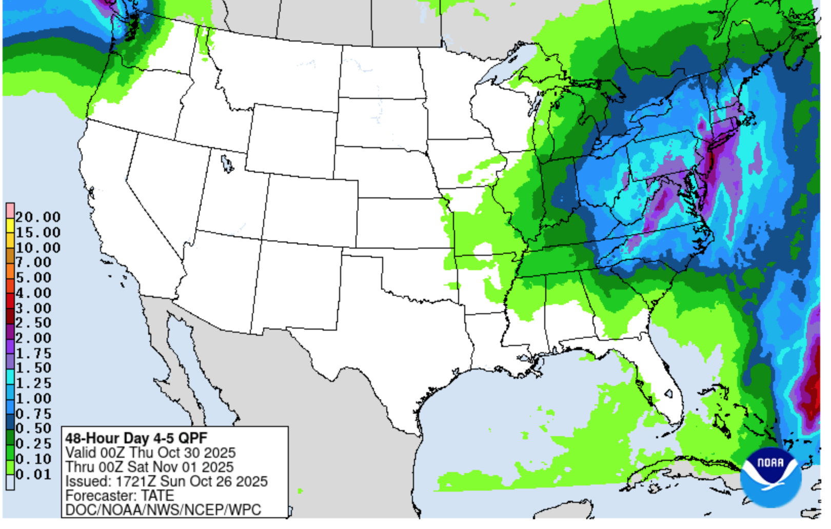
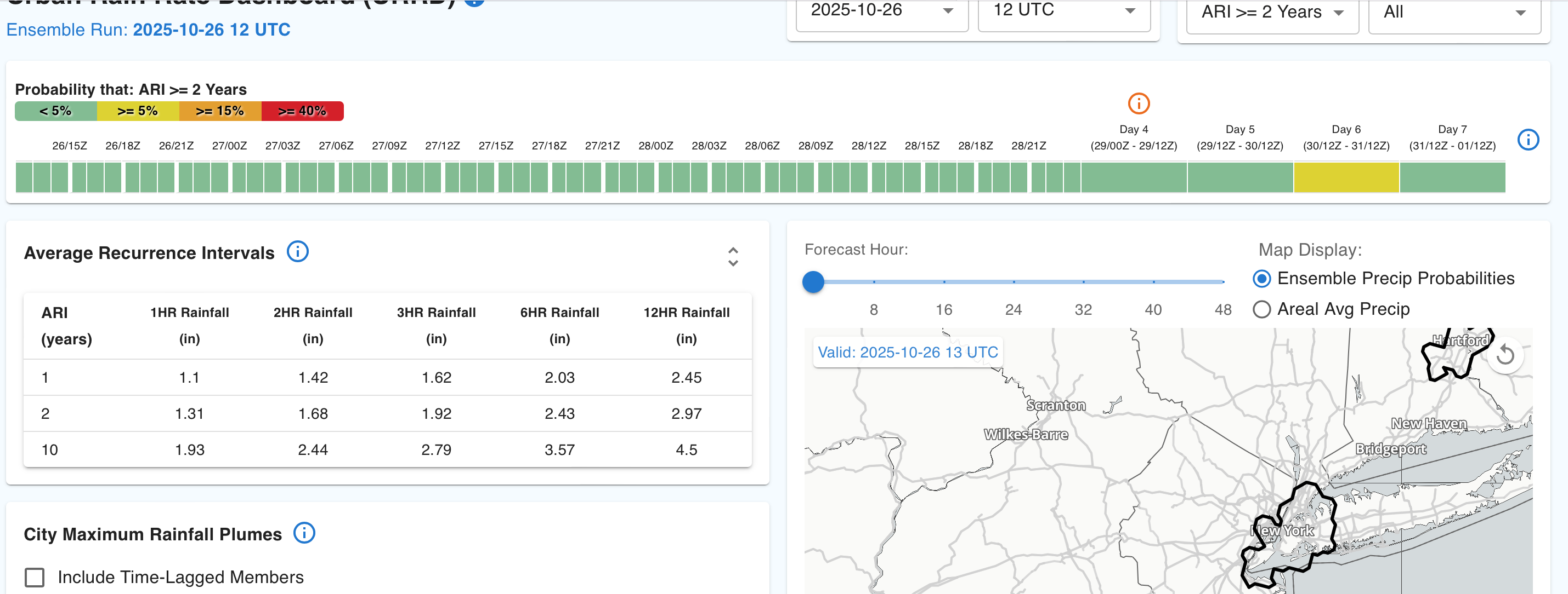
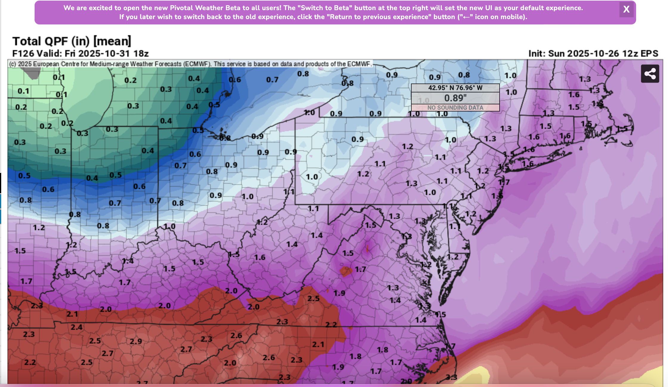
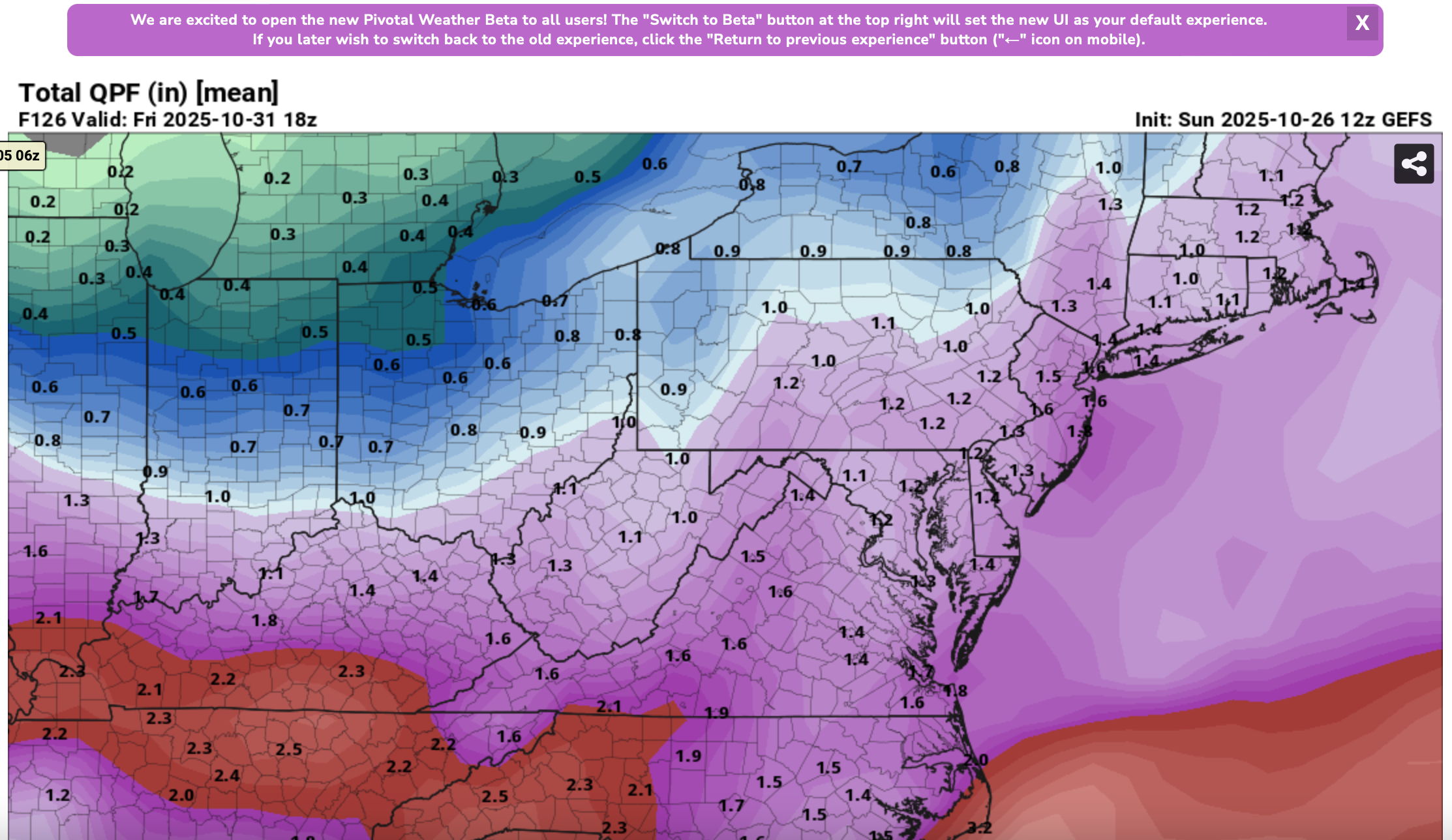
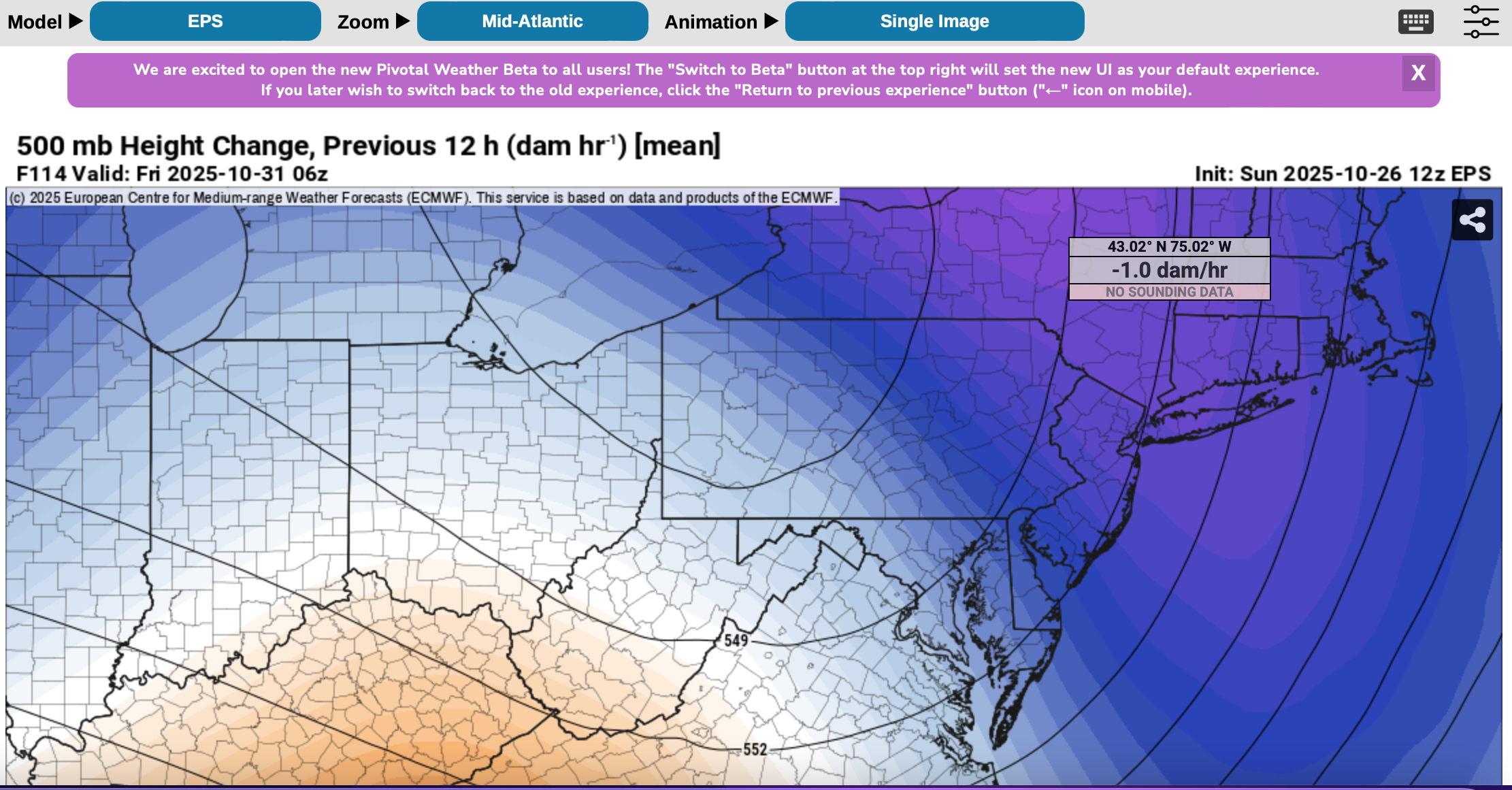
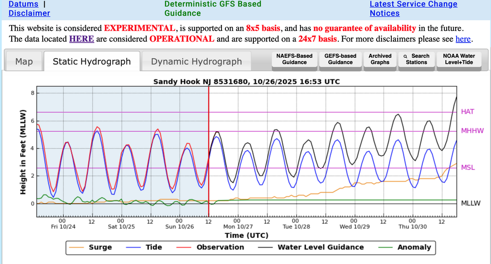
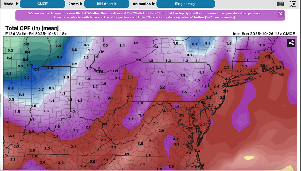
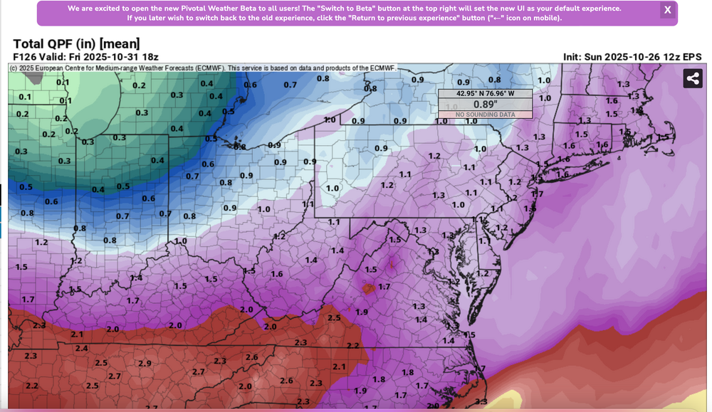
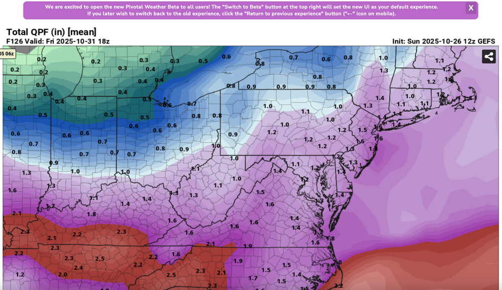
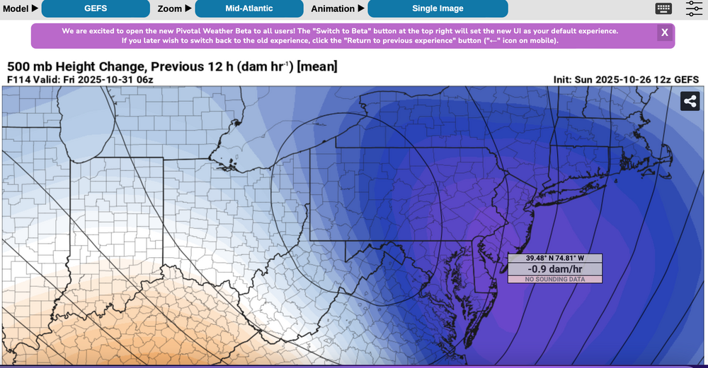
 Please follow any NWS Watches, warnings, statements that may arise from this coming minor or moderate event. This is a D4-5 advance heads-up thread for those who have a need to be advised. Modeling has plenty of spread in solutions so that the ensembles are somewhat muted. There is no doubt in my mind that some sort of minor or possibly moderate impact event is coming. Modeling has been wavering for the past 4 days and hopefully uncertainties resolve by mid week. If I had plans as a motorist or via air travel Thursday-early Friday, I'd think about delays and how to minimize adverse impact, then possibly implement changes Tuesday or Wednesday Timing of the 6-10 hour worst case is uncertain. Beneficial rainfall should result in October totals at all NWS OKX-Upton climate sites roughly 3.3-4.3", within about 1/2" of normal. Not everyone will get 1"+ but the attached Sunday afternoon 10/26 WPC guidance is a best estimate for D4-5. Rainfall still could end up less than indicated. A graphic of average return interval (ARI) for various event amounts, at NYC, is attached-not alarming. This could still end up a routine event although I think wind can add impact. Rainfall intensity during one of the rush hours combined with potential for a period of east-southeast wind gusts 45-55 mph on the remaining wet fully leaved trees may result in a scattering of broken limb caused power outages, similar to the 10/12-13 event. Lunar cycle argues for maximum worst case coastal flooding in the minor category. Modeling from P-Surge is attached. It might be too robust (follow NWS), suggesting a worst cause 3 ft surge along parts of the coasts during the Thursday afternoon-evening high tide cycle (using Sandy Hook as example). Lowered pressure this time compared to 10/12-13 contributes to the surge. Please be aware ensembles are not showing much more than 50-55knot se inflow here, limiting potential for excessive rainfall and surge. There is a slightest chance for isolated severe however CAPE seems to be very limited, despite the favorable strong shear and diffluent upper level flow. A 100-150M 12 hour 500 MB Height Fall Center circles northeastward from the southeast central USA into PA/NJ early Friday. That helps drive the relatively short duration heavy rain event. Presuming the upper Low continues to evolve northward through PA into NYS the eastern Great Lakes there should be a progressive rapid improvement sometime Friday morning. Westerly winds may gust 25-35 MPH at times during Halloween evening but hopefully without any showers in the area. Ensemble rainfall from several modeling centers has been attached as something to look back upon Saturday 11/1 when all the totals are in. The 500MB ensembles attached also show the 12 hr HFC. Fairly modest in comparison to some of the operational cycles we've been seeing the past several days. If the 5h ensemble pattern prevails or is further west, then we've tracked a routine event. The thread current headline will eventually update if moderate impact potential decreases. For now this hopefully adequately summarizes what is on the table for rain/wind/coastal concerns. Let's see if its worth tracking. 620P/26
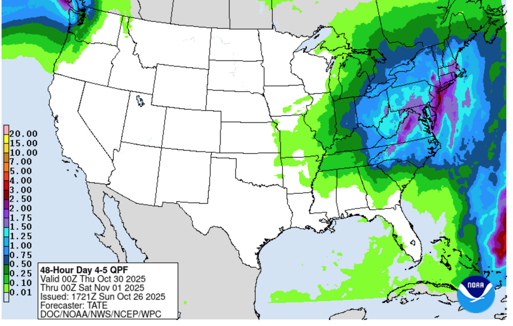


- 246 replies
-
- 12
-

-

-
- heavy rain
- damaging wind? squalls?
- (and 2 more)
-
The modeled next powerful storm into the Great Lakes region should add around another inch of rain in 6-12 hours Friday night, possibly causing renewed urban, basement and small stream flooding and probably extending on-going mainstem flooding in the NYCsubforum through the weekend. Maximum south-southeast coastal gusts possibly capped around 50 MPH along the shore Friday night but when the storm gets into Canada, backside westerly gusts might hit 50 MPH anywhere in the NYC subforum for brief periods of time later Saturday into Sunday. So some power outages are possible. Coastal flooding does not appear to be a large threat. Snow-sleet-freezing rain is anticipated at the start Friday afternoon-evening along the I84 corridor bordering the northwest portion of NYC subforum with "possible" short duration amounts generally 1/2-2" mainly in the high terrain above roughly 1000 feet. I84 corridor valleys, probably little or no accumulation. Max rainfall from this storm maybe ~2'? This thread will also serve as the OBS thread for this anticipated event.
- 90 replies
-
- 5
-
-
- flooding rains
- damaging wind? squalls?
- (and 2 more)
-
Another significant weather event is headed our way, about 7-8 days after the last. By the time the first day of winter officially starts, we may see a little snow or ice for the interior and substantial rainfall that could prompt flood and coastal flood statements for our area. Sunday-Thursday "potential pair" of wet events that could eventually change to ice or wet snow, especially I84 elevations Tuesday-Wednesday. Substantial rainfall is outlooked... probably at least an inch for virtually the entire NYC subforum and possibly """isolated 6"""" worst case. Not saying 6" will occur but it's in some of the advance modeling and it could end up over the fish. Persistent northeast winds for possibly up to 4-5 days could be a coastal flood problem. A disturbance in the southwest USA today-Wednesday 12/13 migrates east, ingesting short waves from the northern stream and a juicy one out of the Gulf of Mexico. Then it apparently plods northeast along the east coast. How close the upper low comes up here before fading east is with the traditional uncertainty and TBD, but it will be interesting to monitor. There could be a significant banding signal well to the northwest of the upper low and if that upper low holds together longer and eventually makes it up to the south of LI by the start of winter., it will have produced quite bit of impact here. That is still very uncertain and not a lock. Modeling seen through 06z/13: EC-EPS is basically one and done by late Tuesday, but it even flags interior snowfall, the GEFS is most robust for wintry weather and the CMCE, a slightly warmer model, also has some wintry stuff a little further north of I84. All ensembles agree on accumulations Adirondacks. This is another El Niño event, that is particularly juicy (see FL coast pressure intensity), and has a noticeable RRQ of the upper jet near the Canadian Maritimes (southern-northern stream merge) to assist upward motion. Will there be two events next week? or just one centered on Monday? Title update 6AM Saturday from the original that follows: added Damaging gusts LI/CT. A single or pair of nor'easters Noon Sun Dec 17, 2023 - Thu evening Dec 21. Potential: flooding rain I95 corridor, persistent gusty ne wind driven tidal flooding episodes next week, change to ice or snow interior elevations by Tue morning.
- 489 replies
-
- 11
-
-
-
- flooding rains
- coastal flooding
- (and 4 more)
-
Good Friday morning everyone, A consistently modeled 970s MB low moving into southeast Canada later Saturday will develop a strong low level 55-70 knot 850MB southwest jet ahead of it and a period of 50 knot west-northwest dry cold advection 850 MB winds behind it. A dying squall line is possible with the cold frontal passage Saturday evening. SPC has a D2 marginal risk for severe. Much of the guidance has near 45 MPH wind gusts for a fairly large portion of our area along the front with potential for pockets of 50-65 MPH gusts accompanying the squall line (could be just heavy showers and no thunder). This event should be a little more widespread than the previous two early December events. Mount Holly already has a wind advisory posted from 1PM Sat-1AM Sun. In advance, there could be isolated gusts 45+MPH during the afternoon in rather warm southwest flow but the main show should be with and just after the cold frontal passage-gust front during the early night, beginning over the Poconos around 6PM and sweeping east of the Twin Forks by around midnight. At least spotty tree-powerline damage should occur. Courtesy to the the NWS and Pivatol Weather for their graphics (SPC D2 outlook) and the (ECMWF sounding near LGA at squall line passage - a bit isothermal in the boundary layer which is a possible hindrance to transfer). Title: added OBS-NOWCAST in front of the previous title at 636AM 12/11/21.
-
Low to moderate confidence for a damaging wind event (scattered pockets). We're about 48 hours away and within a time that we should be looking for a possible significant event. Not a lock for damaging south wind gust 40-60 MPH in squalls, with an isolated SVR thunderstorm associated with a cold frontal passage, or... brief westerly wind gust to 45-50 MPH within 3 hours of the CFP - associated with strong dry air advection and modest pressure rises. The NAM/UK/EC have 65-75 kt winds near 850 MB at about 7PM Sunday over LI. RGEM even stronger. Op GFS is weakest. As we draw closer to Sunday afternoon, intensity of the wind fields and instability-and any squall lines will need reassessments. The upper 50s SST may limit transfer but lapse rates and any squall lines/kinks or breaks in the lines will be important discriminators for a sizable power outage event on LI/CT. Further west... if damage is to occur in NJ/se NYS, I'll look at hill towns first, and then along the immediate NJ coast, and especially IF, the currently modeled wind fields maintain intensity and can begin sooner as per the RGEM, which is the strongest of the models that I've seen from the 12z-18z/13 cycles. So, to avoid a damaging wind gust, NAM/RGEM/ECMWF/UKMET 65kt+ wind gusts need to weaken 10-15 kt, or a triple point low forms just s of LI. Have three 12z/13 RGEM graphics (slower than the NAM) 4P-7P-10P, added a prob for wind gusts 40+ MPH by the weaker 12z/13 GEFS. Added 18z/13 3K NAM turbulence Richardson # overturning graphic for LGA that is solid .25 up about 925 MB which may favor spotty mixing on the southerly flow and more widespread mixing on the slightly weaker westerly flow behind the front. Also added the 3K NAM modeled wind field from the 18z/13 3K NAM---also for LGA. EC has 3 successive cycles of 40+ MPH for LI/CT and past two cycles 50-60 MPH. Uncertainty on 60 MPH but confidence for ~40, scattered 50 MPH is at at least moderate. RGEM timing below is slower than the 3KNAM. By the way...models have the showers moving east at 62kt. 722P/13