

TellicoWx
-
Posts
2,101 -
Joined
-
Last visited
Content Type
Profiles
Blogs
Forums
American Weather
Media Demo
Store
Gallery
Posts posted by TellicoWx
-
-
-
1 minute ago, John1122 said:
This thing is going to lay down 12+ over a large area pre-ratio.
Big jump sw into the central valley
-
Just had a rain shower pass, so what's showing on radar is making it to the ground precip wise.
-
 1
1
-
-
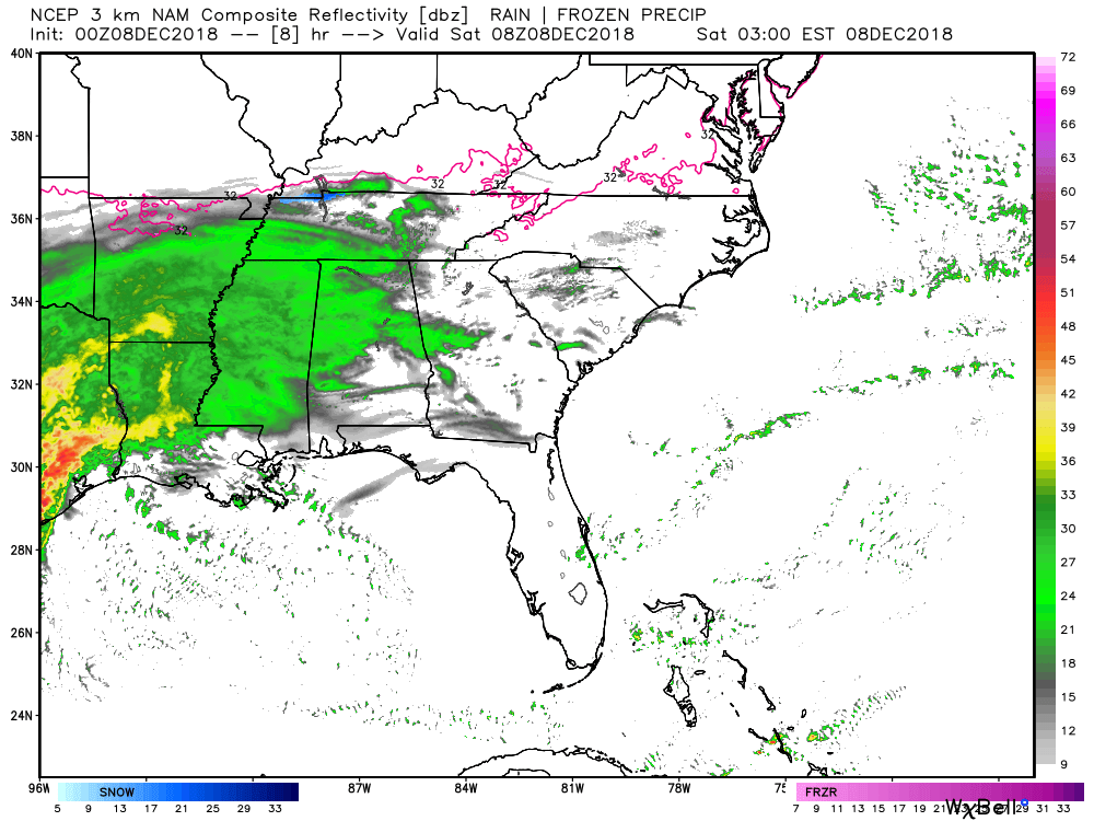
Now that we are starting to enter the nowcast as far as the initial front end and for western areas, 2 things that kinda standout comparing the current radar and 3k NAM. 1) the dry air over SW TN is slightly stronger than modeled and the precip over N GA is ahead of schedule.

-
00z EPS has finally synced up with the OP fairly well on individual members. Shows how the missing data ingest on the 12z run really plays into the chaos theory side of models.
-
1
-
-
13 minutes ago, John1122 said:
Through 30 the GFS is 100+ miles east of the other models.
Think GFS is still in left field, but also didn't like seeing the NAM speed up either
-
11 minutes ago, Carvers Gap said:
LOL. The 0z RGEM for NE TN and SW VA. I think my power just flickered thinking about it.


Lol, yeah RGEM says to buy some candles

-
1
-
-
The system sped up a little on the NAM so the moisture return and lift are exiting quicker.


-
Freezing Rain FV3
.thumb.png.f6557d1378da7b2aa7db585331fe0842.png)
-
1
-
-
18z FV3
.thumb.png.76152a381556f0fa51d7fd8c696328eb.png)
-
27 minutes ago, Kasper said:
Welp, Here we go again, looks like a nice Cold Rain Event for my area “Southern Valley” ie. Athens. A bit disappointing to have that much moisture and just not enough cold.
FV3 looks like it will throw you a couple inches, still waiting on pivotal to upload for a closer map.
-
1
-
-
Much of west TN on the 18z GFS would prob be some type of winter weather advisory or freezing rain advisory I would assume. That wasn't there either at 12z.
.thumb.png.1bcefff22447dff1f6907aa4345c2f17.png)
-
 1
1
-
-
18z GFS

-
18z RGEM HR 48 is .10"-.25" Freezing rain with .50" sleet in NE TN...just started changeover with plenty more moisture to come.
-
Hr 42 unfortunately on the NAM is depicting Freezing Rain there.

-
2 minutes ago, John1122 said:
Per JKL the 18z and 0z runs will finally have fully sampled data from the wave in California. The 12z runs did not.
That could definitely explain the spreads on the EPS members then.
-
.90" of freezing rain, then 5"-8" of snow on top of that in NE TN....think I would pass lol.

-
Some ugly Freezing Rain totals on the NAM and 3K
.thumb.png.4b4d000dd12260014c9c20899498543d.png)

-
3K NAM:

-
1
-
-
-
41 minutes ago, EastKnox said:
Are we in no mans land at the moment? The snowfall I'm looking at is happening at 48-72 hours and many agree that the mesoscale models at that range are unreliable.
Ensembles basically use chaos theory and test it by change one initial very small variable in the atmosphere to see the effect on a system. The wide range on the EPS members show how dynamic and changing this system still is. From ECMWF:
"In a chaotic system, a slight change in the input conditions can lead to a significant change in the output forecast. In a non-chaotic system, small differences in initial conditions only give small differences in output. Hence, it is important in weather forecasting to investigate how sensitive the atmosphere is at any stage to initial conditions. Ensemble forecasting does this by looking at a spread of possible outcomes."
-
1
-
-
Ensembles lose wieght at this range, due to the general area doesn't change as much and we can look at the meso models to pinpoint more localized points within that area...members can't even figure where that area is within 48 hrs.
-
Kind of crazy to have this many different outcomes this close to an event lol


-
12z EPS

-
1
-


.png.8b1366f6a9fa80de389b8e707159499f.png)
.png.5fc9225878f065781665aaae23e8fcef.png)
.png.58107829407f504f51fc321ec4180a40.png)


.png.98db60464826356accf4ab6d56497a33.png)


December 8-10 Storm Discussion
in Tennessee Valley
Posted