

TellicoWx
-
Posts
2,283 -
Joined
-
Last visited
Content Type
Profiles
Blogs
Forums
American Weather
Media Demo
Store
Gallery
Posts posted by TellicoWx
-
-
Bad situation in Davidson Co and surrounding areas...overlapping FFW in that area.
-
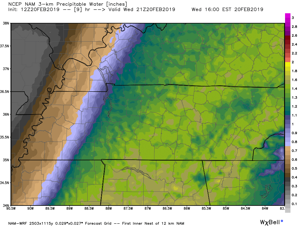
Starting to become a little more concerned this afternoon and overnight for the central and southern valley. Risk of flash flooding from torrential rain and training is increasing on the hi res models. PWAT values are near 1.6+ coming up the valley now, with storms training over the area. Unlike the past couple waves involving a large rain shield, 1.5+ is being produced over a very short time.
12z 3k and HRRR

-
 1
1
-
-
Town has lost power now...numerous outages county wide
-
1 hour ago, Math/Met said:
Everything still looks on track for a significant mountain wave wind event. It has taken awhile for conditions to become favorable. Even though VWP indicates 40kt SE winds at 4000ft, the cross barrier flow remains blocked. Camp Creek winds haven't really increased yet and aren't currently blowing from a SE direction.
Conditions become much more favorable in the next few hours. HRRR is showing the enhancement right along the mountains and especially in the Camp Creek area by tomorrow morning. That's not the most reliable wind product, but it usually does a good job of showing areas of mountain wave enhancement (even if wind speed isn't accurate). The biggest question for me is how trees will hold up in areas with possible 75+ mph wind gusts and saturated soil.
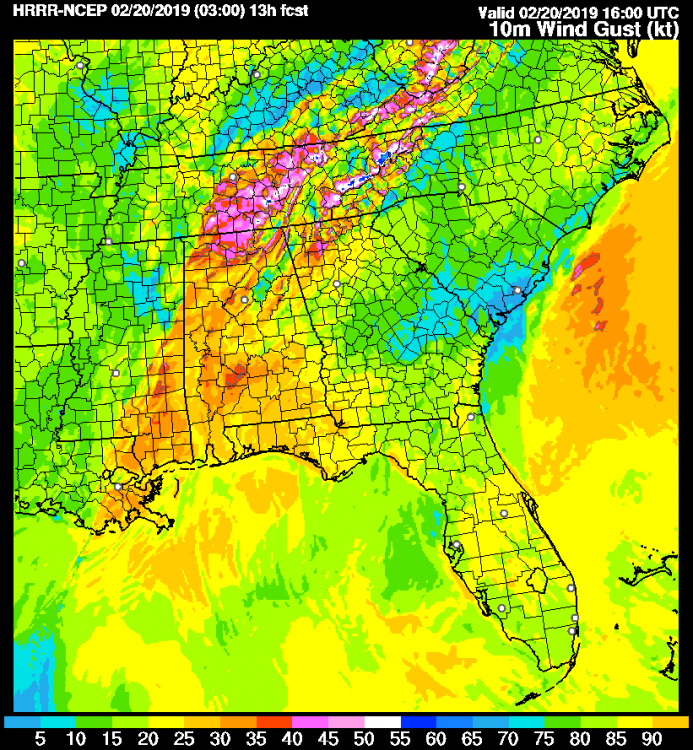
Already have 73 customers out here in the southern part of Monroe Co.
-
22 minutes ago, Math/Met said:
About 30 minutes after posting that, Camp Creek switched to a SE wind and gusted to 53mph. It should continue to increase.
Wind has begun to pick up here as well...temp shot up to 50
-
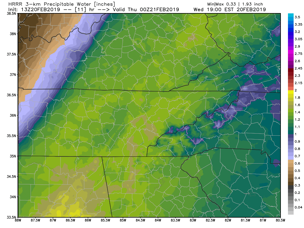
Concerning...Heavy rainfall...Flash flooding possible

Valid 200353Z - 200953Z

Summary...An uptick in moderate to heavy showers and thunderstorms
overnight, with the potential for repeating rounds, will raise the
risk of flash flooding across portions of the mid-MS, TN, and
lower OH Valleys.

Discussion...Deep mid/upper level trough over the Southwest US and
+140 kt jet downstream has put the lower/mid MS, TN, and lower OH
River Valleys well within the favorable right entrance region this
evening. Southerly flow in the low levels is surging higher
moisture northward, characterized by an increase in PWs, now
ranging from 1.2 to 1.4" per latest TPW blends and RAP
mesoanalysis.

Regional radar imagery shows plenty of elevated showers and
thunderstorms ongoing from the Arklatex region northeastward
toward the confluence of the OH and MS Rivers with a noted cooling
in the IR imagery cloud tops. This is supported by the RAP
analysis of 500-1500 J/kg of MUCAPE as far north as the TN/KY
border.

Over the next several hours, the low level jet is expected to
increase with 850 mb winds forecast between 50-70 kts by 07-08z.
This should act to further surge the anomalously high PWs (2-3 SD
above the mean) northward. Convection should continue to blossom
over the region and with the expected storm motion (southwest to
northeast) closely aligned with the mean flow, repeating rounds
and training will be possible.

Hi-res models indicate that through about 10z, a swath of 1-2"
with local amounts near 3", will be possible from central/eastern
AR, western TN, northern MS, and southwest KY. This region has
been running very wet the last 14 days (300-400 percent of normal)
so the additional rainfall combined with colder ground surfaces
will lead to enhanced runoff and potential flash flooding.

-
00z GFS came in a lot drier between 12z Wed- 12z Thur for the E TN valley...still a big threat for the plateau and west.
-
MRX with a Flood Advisory for the entire CWA now
-
Flood Advisory for the southern 1/3 of the E TN valley now
-
Photo courtesy WPVFD...small section of the shoulder on Hwy 30 has slide off

-
Trying to get more info, but per West Polk FD...A section of westbound Hwy 30 in Polk Co is closed..either due to a slide or a section of the road collapsed.
-
 1
1
-
-
Hwy 321 is closed again at the Kinzel Springs rockslide
-
Delta Flight from Milwaukee struck by lightning and made emergency landing at Chattanooga airport.
-
1
-
-
From GSP Twitter page, Newfound Gap.
Can't help but wonder how this may actually increase the slide potential across the higher elevations once the warm are pushes thru and unthaws the ground.

-
18z NAM doubled the totals across SE TN thru Fri evening. Went from 1.5-2 to 3-4
-
Current conditions Ft Payne AL:
Rain rate 1.13" hr..total 1.04"
Nickel size hail reported and numerous lightning strikes...temp 39.2
Impressive dynamics.
-
1
-
-
TVA began flow reduction at the tributary dams here in East TN at noon today.
-
Just had a quick burst of moderate sleet here...cold not wanting to budge quickly.
-
Prob belongs in the other thread, but the 12z GEFS keeps the flow setup over the same region thru the run...ugly run for the flood threat areas. If we can't shut the Gulf down, this threat may extend well beyond current thinking.
12z GEFS (Complete run total):
.thumb.png.0a47256493bc20b4195b5e8b496af2a4.png)
-
4 hours ago, janetjanet998 said:
well with light rain moving into the southern TVA area..lets call the event started....it may rain continuously somewhere in watershed (TVA/OH) the whole week.....best chance for a break in between systems on Thursday as the firehose weakens and heads south before the next wave
lake Cumberland as of 10pm last night 739.52 should hit 740 this morning..record 751.7ish. 2.5-3.5 inches basin wide should break it if outflows remain 29,000ish....any training ..all bets are off
OH river crest without the big weekend system (both points running ahead of last nights forecast points)
Paducah 49.5
cairo 53
both top 18 all time crests (even a slight increase will move up the list fast)
Lake Barkley/KY lake levels about 755.1 feet. summer pool 759. record 772ish..outflows into OH 282,000 cfs
the weekend event looks troubling because there is potential of the front to get hung up , usually poorly modeled, due to convection and training.....
12z GFS hangs the initial front across SE TN instead of pushing thru into N GA. Def something to watch.
-
Don't like how 00z suite has started..NAM quicker with onset, larger shield with WF, and less of a break. Rate of decent here is slowing over last couple hours and still near flood stage, need every hour we can get. As Carver mentioned earlier, will not take much of anything to top the banks again (let alone the 3+ the 3k is showing for this next event for near the state line.
-
Nearing 4 Trillion Gals forecast for TN.
KY: 3.4 Tril, 6.47 Max, 4.84 Avg
AL: 2.9 Tril, 6.57 Max, 3.21 Avg
MS: 3.6 Tril, 6.56 Max, 4.27 Avg
7.3 Trillion just for OH/TN watershed.

-
WPC going 2-3" for midweek across SE TN...5-7" still thru weekend.

.gif.fb951f4cdb0fd2d97b9c1a8508bf32e5.gif)
-
2 hours ago, Carvers Gap said:
I am all for those totals being backed-down. 3-4" is about the max that we can handle here before it gets ugly. My area that I jog is now under water and seems like the "base state" for that current area - meaning it is out of its banks and not receding quickly. We can probably handle 3-4" over the period of a week, though there will likely be urban flooding etc. The bigger numbers in SE TN and west of that are trouble for the TN River system. I was commenting earlier that the absolute thing that we don't want in the LR is a big snowstorm in the mountains followed by another active STJ firehose that melts it all at once. Folks in the foothills communities know that is bad business.
Each system has been like a stepping block. Definitely a rising "base". At 2000 cubic feet second we enter flood stage here.

-
2
-


.png.0eef62775f250cadef6860bc23471570.png)

TN valley heavy rain/flooding week of whenever
in Tennessee Valley
Posted
Not a good warning map this morning in Middle TN