

TellicoWx
-
Posts
2,101 -
Joined
-
Last visited
Content Type
Profiles
Blogs
Forums
American Weather
Media Demo
Store
Gallery
Posts posted by TellicoWx
-
-
12z EPS increasing totals again
-
3 minutes ago, Holston_River_Rambler said:
The pieces were still there in nearly the same places at 0z, but still quite a bit of bounce. It was all there this time. Just the right amount of NE confluence. Just the right size and angle for the W. ridge. Just the right timing for both chunks of energy. Man I wish this were the first run after the energy came on shore!
Not to sound too Willy Wonka, but if that NS energy were to ever speed up and fully phase, this storm could be even crazier.
-
 2
2
-
-
1 minute ago, Carvers Gap said:
You know, I have no idea of that ever comes to pass. That is an awesome and extreme run. It almost grabbed an extra fetch off the Atlantic. I would love to completely discount the run so as not to put myself through the miser of it not verifying...but it did almost the same thing at 0z. That is at least the second run of its type.
EPS will be interesting..previous 3 have had similar members as that OP run for TYS and slowly increasing each run. 00z had 7 members with 6"+ output.
-
1
-
-
1 minute ago, jaxjagman said:
Just saw the max 41.7",where is that?
WNC mtns
-
1
-
-
Think Jeff used some reverse psychology on the Euro that run (except for poor Hamilton Co) lol jk.
-
 2
2
-
-
Pushing 3' on northern plateau and a 12" in TYS.
-
Just now, Carvers Gap said:
Gonna be waaaay more than that.
Yeah, it's still going on further frames
-
1
-
-
Wow...mods can delete this if it violates anything.

-
2
-
 1
1
-
-
You guys along 40 across the state and north to KY line will also love this run.
-
12z Euro coming in south of 00z, hammers all of the plateau.
-
12z GEFS mean:

-
1
-
1
-
-
Very interested in what the GEFS and especially the UKie did, it is usually a precursor to the Euro.
-
1 minute ago, Carvers Gap said:
Anyone have a link to those nice UK maps that were posted the other day w the satellite look?
Grit in SE forum said he was using the EWall 4 panel
-
1
-
-
Hearing the Ukie is coming in with a big, but little late phase now in the gulf.
-
1
-
-
4 minutes ago, Carvers Gap said:
The 12z suite so far (ICON, GFS, CMC) are starting to hone-in on a track and have some agreement. It is notable to see the ICON put snow accumulations into the norther Valley on that run. The CMC is a bit of an outlier w the energy transfer business, but somehow manages a similar snow axis. NE TN does well on those runs w what would be a sharp cutoff to the west verbatim. For E TN, the more this bends up the coast, the better. It will allow things to pivot if we can keep the slp over the coastal plain and inside Hatteras. Waiting on the FV3 at the moment...
Yeah the 12z runs out so far are taking baby steps towards what you have been discussing this morning and what was in MRX write-up with a more traditional Miller A.
-
Ensemble trends for last 9 GEFS and 4 EPS runs. Oldest>Latest Mean Snowfall
TRI: (GEFS) 3, 4, 4, 3.5, 3.5, 4, 4.5, 4.5, 6.5 (EPS) 1, 3, 5.5, 7
TYS: (GEFS) 2.5, 3.5, 3, 3.5, 3, 4, 3.5, 3, 5 (EPS) 3, 1.2, 2, 2.4
CROSS: (GEFS) 3.5, 5, 5, 4, 4.5, 5, 5, 3, 6 (EPS) 1, 3, 4, 4
The southern 1/4 of the state has generally stayed in the 1 to 1.5 range. While the OPs have been all over the place the last couple days, the ensembles have slowly been trending in the right direction for the upper half of the state.
-
2
-
-
36 minutes ago, Carvers Gap said:
Interestingly, there are some almost Miller A/Noreaster solutions this AM. The 0z CMC is a boomer w some energy transfer(not a fan of that...). The FV3 makes an effort. We need to watch that trend. If that trend were to continue, that changes the entire equation if so. I would not be surprised if it did.
Yeah this thing is still in ensemble watch mode. Personally, an old friend of mine who was a met forever once told me 3+ days out =ensemble for upper pattern, 1-3 days = ops for the surface features, and under 1 day the meso models to fine tune things. The last 3 runs have seen the ensembles creep every slowly south and increase north of 40.
-
4
-
1
-
-
0z EPS is almost identical to 12z, only change really was it increased the mean across NE TN.
-
1
-
-
10 minutes ago, AMZ8990 said:
@TellicoWx, what was the mean for Memphis or Jackson Tn?
1" for both
-
1
-
-
12z EPS mean:
TRI: 6"
TYS: 2" (south knox), 3.5" (north knox)
Chat: 2"
Cross: 4"
Highest run so far for northeast TN. EPS looks almost identical to GEFS mean.
-
1
-
-
12z EPS has went with a more southern solution vs previous run. Mean LP is south of PCB, FL.
-
1
-
-
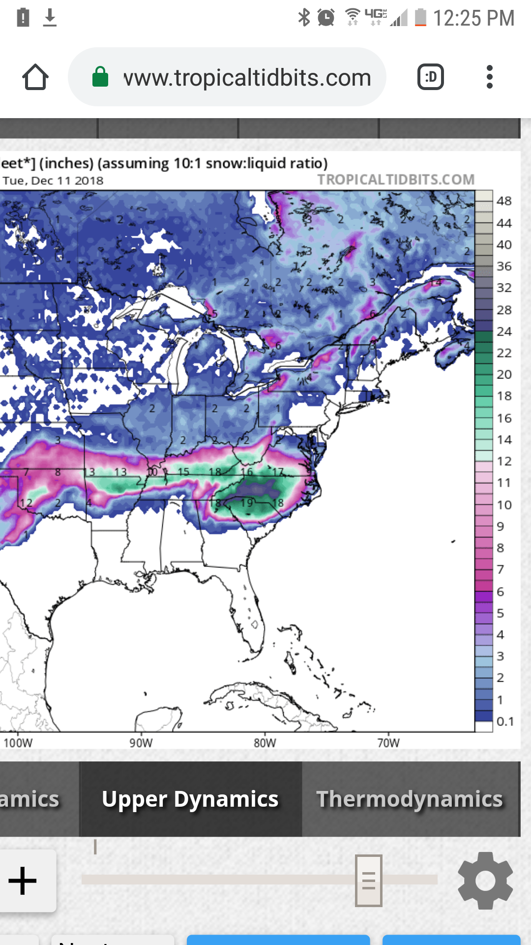
College of Dupage site does a better job taking the sleet out of the accumulation maps. Here's the 12z FV3 Kuchera:

-
2
-
-
20 minutes ago, Bango said:
Are these fv3 snowfall outputs remotely correct ha? This is dgex type algorithms
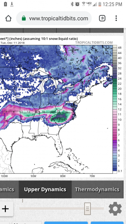
College of Dupage site does a better job taking the sleet out of the accumulation maps for the FV3. 12z FV3 Kuchera Acc map:

-
1
-
-
Lol at Goofy "Aw crap I was suppose to have a storm along the coast, here let me blowup this LP near Charleston"


December 8-10 Storm Discussion
in Tennessee Valley
Posted
12z EPS...cant ask for too much more at 5 days out