
baroclinic_instability
-
Posts
7,869 -
Joined
-
Last visited
Content Type
Profiles
Blogs
Forums
American Weather
Media Demo
Store
Gallery
Everything posted by baroclinic_instability
-

Alaska/Western Canada obs and discussion
baroclinic_instability replied to patrick7032's topic in Central/Western States
If you use COD text it will remain formatted. 240 FXAK68 PAFC 101252 AFDAFC SOUTHCENTRAL AND SOUTHWEST ALASKA FORECAST DISCUSSION NATIONAL WEATHER SERVICE ANCHORAGE AK 500 AM AKDT SAT SEP 10 2011 ANALYSIS AND UPPER LEVELS COMPLEX SPLIT UPPER FLOW PATTERN EXISTS TODAY WITH EMBEDDED DISTURBANCES IN THE WESTERLIES OVER THE NORTHERN TWO-THIRDS OF THE STATE. LINGERING HIGH AMPLITUDE TROUGH THAT BROUGHT CLIMATOLOGICALLY COOL AND WET WEATHER TO MUCH OF SOUTHERN ALASKA CONTINUES TO GET PINCHED OFF AS RIDGING BUILDS ACROSS THE ALEUTIANS AHEAD OF THE NEXT DISTURBANCE. AN EMBEDDED SHORT-WAVE TROUGH BRINGS THE THREAT OF RAIN TO THE KUSKOKWIM DELTA REGION THIS MORNING. AT THE SURFACE...RIDGING BUILDING WESTWARD ACROSS THE NORTHERN GULF OF ALASKA. MODEL DISCUSSION MODEL GUIDANCE IS IN GOOD AGREEMENT SYNOPTICALLY FOR THE SHORT TERM AS AN UPPER LEVEL LOW DEVELOPS FROM KAMCHATKA PENINSULA AND EAST THIS WEEKEND. MODELS ALL SIMILAR WITH A MID-970MB LOW IN THE NORTHWEST BERING SEA. A WEAKENING SURFACE LOW WILL MOVE INTO THE GULF OF ALASKA BY EARLY MONDAY MORNING IN THE LOW 990MB RANGE. AS THE UPPER LEVEL JET PUSHES SOUTH OF THE ALEUTIANS AN ELONGATED TROUGH WILL STRETCH FROM EAST ASIA THROUGH THE CENTRAL ALEUTIANS WITH AN EXTENSION INTO THE GULF OF ALASKA. SHORT TERM FORECAST SOUTHCENTRAL ALASKA...CONSIDERABLY DRIER WEATHER FOR MUCH OF THE AREA WITH RELATIVELY WEAK FLOW ALOFT. PARTLY CLOUDY TO PARTLY CLEAR CONDITIONS WILL EXIST. DRY CONDITIONS LOOK TO CONTINUE THROUGH THE WEEKEND UNTIL AN UPPER LEVEL DISTURBANCE PUSHES INTO THE GULF BRINGING RAIN TO MAINLY COASTAL AREAS EARLY NEXT WEEK. SOUTHWEST ALASKA...A WEAKENING SHORT-WAVE TROUGH MOVING ONSHORE IN THE YUKON DELTA REGION BRINGS AREAS OF RAIN TO THE KUSKOKWIM DELTA IN THE MORNING AND MOVING INTO THE KUSKOKWIM VALLEY/MTS FOR THE AFTERNOON. GENERALLY CLOUDY CONDITIONS WILL CONTINUE FOR MUCH OF THE SOUTHWEST INTERIOR AND BRISTOL BAY REGIONS. BERING SEA AND ALEUTIANS...UPPER LEVEL DISTURBANCE AND ASSOCIATED FRONT PUSH ACROSS THE CHAIN FROM WEST TO EAST BRINGING PERIODS OF RAIN AND GUSTY SOUTHERLY WINDS THIS WEEKEND. LONG TERM FORECAST FOR THE EXTENDED PERIOD A BROAD UPPER LEVEL LOW WILL BE ANCHORED OVER THE BERING SEA BRINGING GENERALLY CLOUDY CONDITIONS WITH RAIN SHOWERS. AS DISTURBANCES ROTATE AROUND THE FRINGE OF THIS TROUGH PERIODS OF UNSETTLED WEATHER CAN BE EXPECTED FOR COASTAL REGIONS OF THE SOUTH CENTRAL AND THE GULF OF ALASKA. AER/ALU WATCH/WARNING SUMMARY PUBLIC...NONE MARINE...132 150 170 172 179 180 185 FIRE WEATHER...NONE MTL SEP 11 -
Alaska/Western Canada obs and discussion
baroclinic_instability replied to patrick7032's topic in Central/Western States
Ha, +SN = heavy snow. It is the surface observation term used by the surface observing system here. Light, moderate, and heavy are the discriminators used for precipitation rates. So, for instance, light snow would be -SN, moderate snow would simply be SN, and heavy snow would be +SN. Good question though. Thanks for all the nice pictures up there...should be a fun winter up there. Just curious, how did you end up there from France? -
Alaska/Western Canada obs and discussion
baroclinic_instability replied to patrick7032's topic in Central/Western States
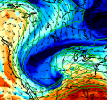
The GOA cyclone is massive, almost the size of the lower 48. Nothing terribly out of the ordinary for the GOA, but nice to see again. Bring on the baroclinic pain.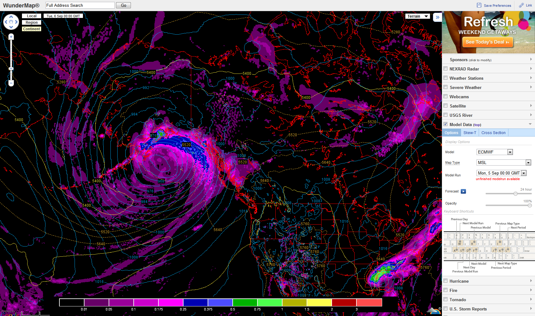
-
Alaska/Western Canada obs and discussion
baroclinic_instability replied to patrick7032's topic in Central/Western States
How did the 0Z Cold Bay sounding look tonite? -
Alaska/Western Canada obs and discussion
baroclinic_instability replied to patrick7032's topic in Central/Western States
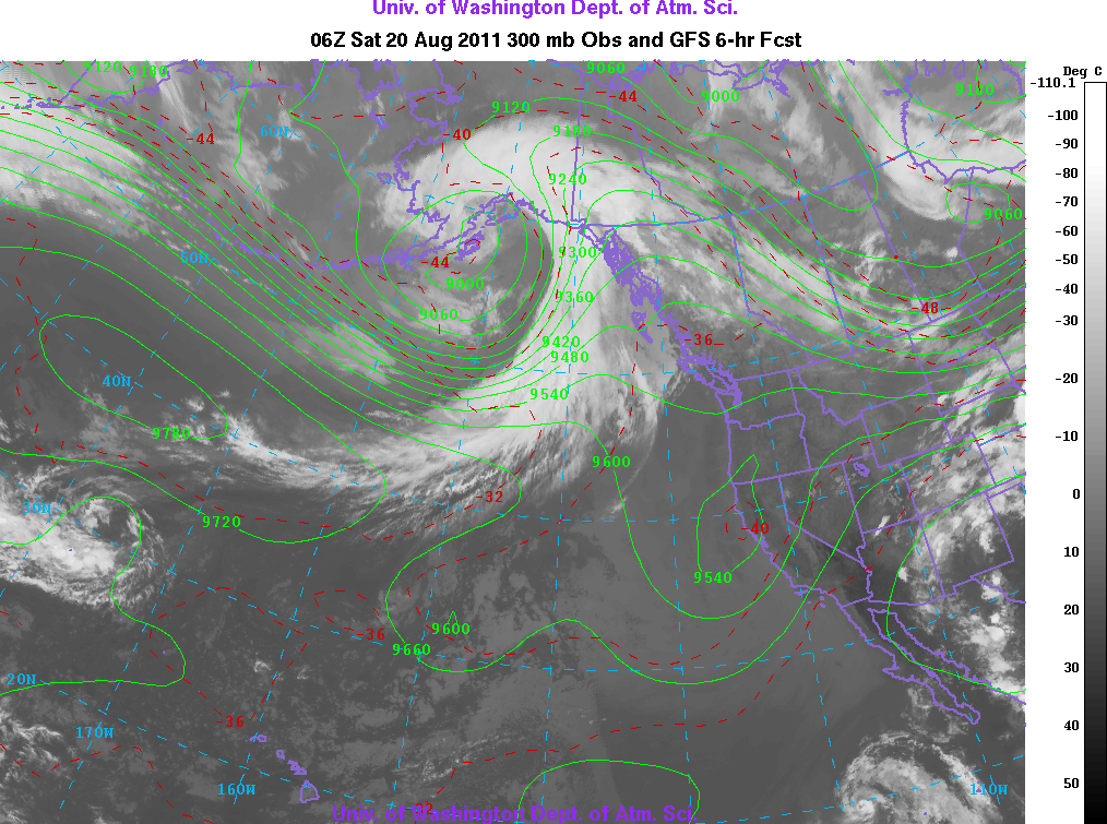
Polar Jet is about to drob the bomb in the Gulf of Alaska with a sub 960 bomb. GFS?EC bomb it out 25-30+ hpa in 24 hours.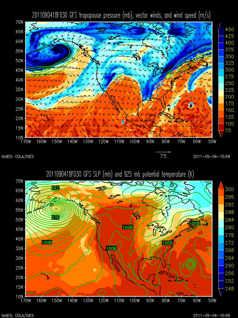
-
Alaska/Western Canada obs and discussion
baroclinic_instability replied to patrick7032's topic in Central/Western States
Yes, from your location. It is a pretty sparsely populated area...not a lot of people have been there before. It would be neat to see images. I know a bit about the terrain/geography, but it would be neat to see images of the locale. -
Alaska/Western Canada obs and discussion
baroclinic_instability replied to patrick7032's topic in Central/Western States
You should post some pictures of the area from up that way. -
Alaska/Western Canada obs and discussion
baroclinic_instability replied to patrick7032's topic in Central/Western States
Welcome to the boards, I am glad to have a weather enthusiast from outside of the lower 48. -
Alaska/Western Canada obs and discussion
baroclinic_instability replied to patrick7032's topic in Central/Western States
Gorgeous. Baroclinic bombs. I will disagree though, there is a fair bit of minor baroclinic pain going in Canada. Hudson Bay doom.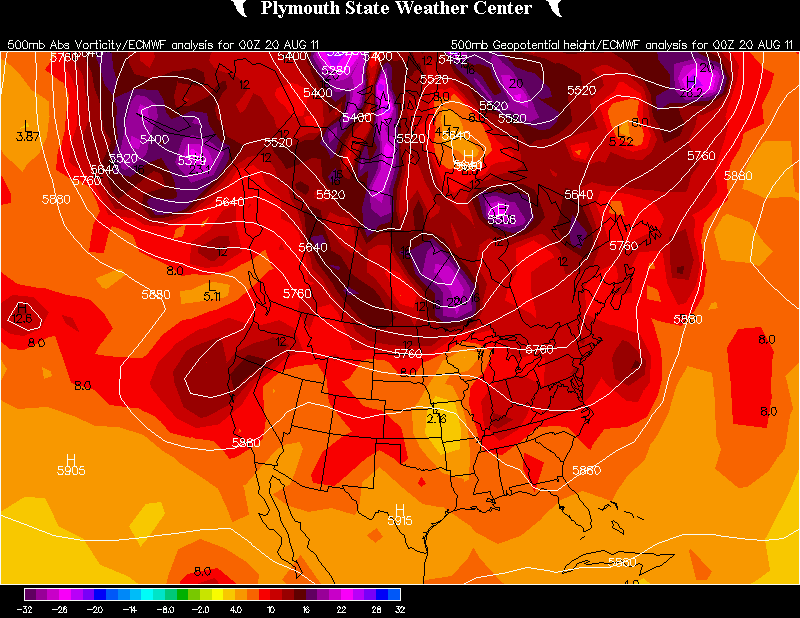
-
Alaska/Western Canada obs and discussion
baroclinic_instability replied to patrick7032's topic in Central/Western States
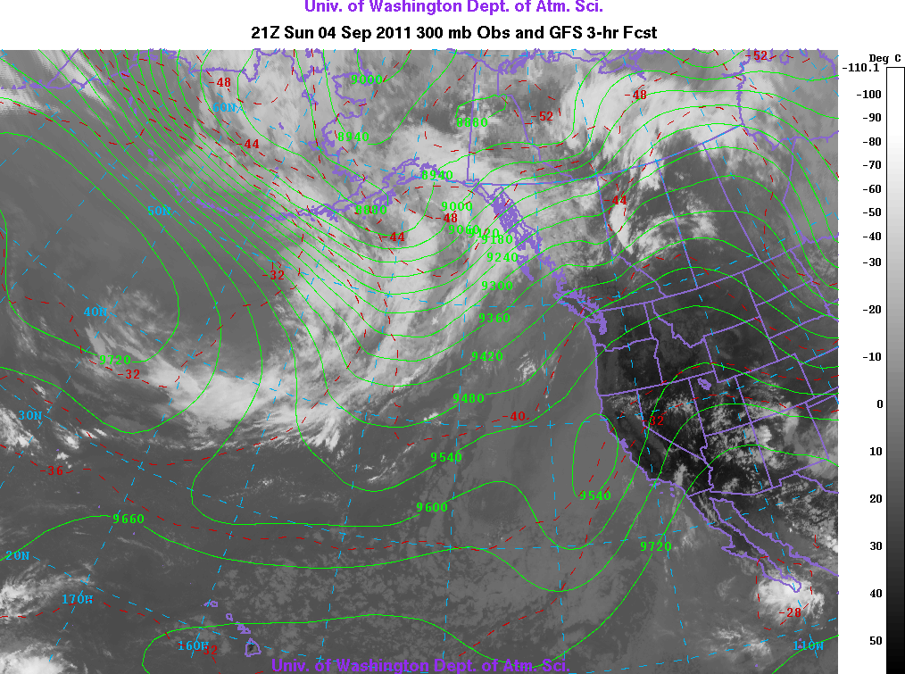
Nice post. Interesting features that stick out in the PABE sounding is the strong above mountain top inversion (around 850 hpa) which probably enhanced the trapped wave mode, but probably too high to incite strong downslope winds given the height of the range. I am assuming no major downslope winds? The other interesting feature is the model cross section which seems to be simulating a vertically propagating mode given the back tilt of the wave w/height. Do you guys have any higher res x-sections? I found the x-section tropopause uniquely flat...also neat to see how the model simulates (actually probably parameterizes) the dampening of the wave as it reaches the tropopause. -
Alaska/Western Canada obs and discussion
baroclinic_instability replied to patrick7032's topic in Central/Western States
Nice maps. Got to love our awesome hygristors. Nice catch though, looks legit, and it makes sense with that type of deep tropopause that stratospheric mixing is occurring. -
Alaska/Western Canada obs and discussion
baroclinic_instability replied to patrick7032's topic in Central/Western States
Those are bada** mtn waves. -
Alaska/Western Canada obs and discussion
baroclinic_instability replied to patrick7032's topic in Central/Western States
Termination dust? I see some DCVA by CD3 progged by the EC/GFS for day 3.5+. Looks pinwheelish. -
Alaska/Western Canada obs and discussion
baroclinic_instability replied to patrick7032's topic in Central/Western States
I am interested. I have been keeping up to date on weather up there lately, perhaps because of you and niumetgf, but also because of the extreme boredom of 600 dm subtropical death ridges. -
Weatherdata is there to make money with respect to a very defined user base with different expectations and impacts. What is too bad is the poor comparison they use in their quote.
-
Glad you are back and ok Jomo
-
It is an incredibly fine line when it comes to tornadoes. Of course crying wolf all the time is not ok since it will inevitably result in the public simply ignoring the warning--but nobody wants to be the one who has no warning on a tornado that potentially kills people. That information needs to get out--and it is likely better that the FAR be a tad high since tor warnings are such a rare event overall.
-
An honest--question, what are the chances V2 would have secured its funding (or the amount of funding it eventually achieved) if it did not include "increased warning times" and "lived saved" in proposals?
-
There are a lot of options out there. I have a number of friends who graduated with a met degree then went into various engineering programs for their M.S. degrees--and they are successful and working in the engineering field. Doing this route would give you a chance to pursue your passion (meteorology) while setting you up for a different field should it not work out. Of course--this would also require that you get a M.S. Double majoring is possible, but that would be tough doing met/engineering at the same time. That is another possibility though.
-
Exactly. I love helping people and having a positive impact in peoples lives--even if they don't know it. Weather is an important job--and that is all anyone could ask for in a career field.
-
Sometimes you make silly points over and over again for no reason (hence why some folks get fed up with your posts)--but I agree with you here. It is such a tough market for all levels of meteorologists from B.S. to Ph.D. I think others have alluded to it here--but the best thing one can do is gain as much unique experience as possible in college to standout from the rest, try and get internships during the summer, volunteer at a NWS office, and double major in a different field for backup.
-
True. There was always the feeling of something extreme, but some (including me) felt some of the other days (by day 3 before the outbreak) may exceed yesterday. Others felt the previous convection would (and resultant cold pool) disrupt yesterdays potential. Others, including me, felt the lack of significant "bombing" would cut down on the hodograph turning, etc. I knew a high risk yesterday was likely by a day and a half ago--but not to the extreme it eventually developed into.
-
I give special kudos to Fred Gossage, TornadoTony, and CUmet who never really wavered from what they believed was a historic event.
-
178 is the latest toll. http://goo.gl/cZUcy Just horrific. I hate tossing numbers around when it is human lives we are talking. Tragic--and it makes me want to work all that much harder to be the best met I can. Horrible news.
-
Birmingham, AL's disco this morning. I could not imagine having to write it. WOW...WHAT A DAY. MANY THOUGHTS AND PRAYERS GO OUT TO THOSE IMPACTED BY WEDNESDAYS HISTORIC TORNADIC OUTBREAK ACROSS THE STATE. TRYING TO WRITE A DISCUSSION AFTER SUCH AN ACTIVE DAY IS QUITE DIFFICULT. HOWEVER THE WEATHER NEVER ENDS AND WE MUST CONTINUE. THE NEXT FEW DAYS WILL BE CLEAR...SO THE CLEAN-UP PROCESS CAN BEGIN ACROSS THE STATE. WE ARE GOING TO GO FROM WELL ABOVE NORMALTEMPERATURES OVER THE PAST FEW DAYS TO ACTUALLY BELOW NORMALTEMPERATURES FOR TODAY AS THE COLD FRONT CONTINUES TO PUSH EAST OFTHE AREA. THERE WILL BE SOME MODERATION IN TEMPERATURES THROUGHSATURDAY.THE NEXT WEATHER WILL BEGIN TO MOVE IN ON SUNDAY AS THE NEXT COLDFRONT APPROACHES FROM THE NORTH. MODELS ARE VERY FAR APART INREGARDS TO THIS TIME-FRAME SO THERE IS QUITE A BIT OF UNCERTAINTYTO SAY THE LEAST. THE EURO BLAST THE FRONT THROUGH THE AREA BYMONDAY...WHILE THE GFS HOLDS THE FRONT UP AND BRINGS US SEVERALBANDS OF SHOWERS AND THUNDERSTORMS THROUGH TUESDAY. LOOKING BACKAT PREVIOUS DAYS ABOUT THE ONLY CONSISTENCY BETWEEN MODELS IS THEFACT THAT THEY CONTINUE TO DISAGREE. HOPEFULLY WE CAN GET SOMECONSISTENCY IN HERE WITHIN THE NEXT DAY OR SO. ONE THING TONOTE...IF THE GFS PANS OUT WE COULD SEE A ROUND OR TWO OF STRONGTO MAYBE EVEN SEVERE STORMS...BUT THE INCONSISTENCIES IN THEMODELS ARE JUST TOO LARGE TO INCLUDE AT THIS TIME.