
baroclinic_instability
-
Posts
7,869 -
Joined
-
Last visited
Content Type
Profiles
Blogs
Forums
American Weather
Media Demo
Store
Gallery
Everything posted by baroclinic_instability
-
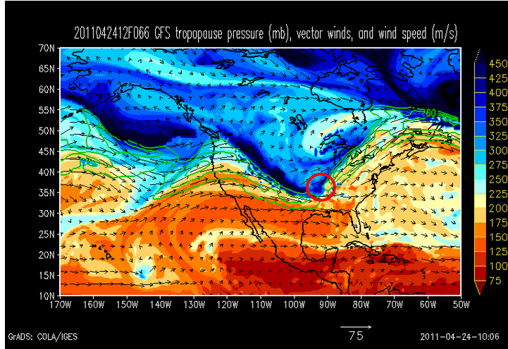
 The NAM shows the potential for separation between the northern stream upper low and the southern stream anomaly with vigorous low level WAA associated with the incoming anomaly nearly creating its "own" ridge and decent separation between the synoptic lows. Should such a scenario unfold it would undoubtedly be a historic tornado day verbatim NAM with locally backed wind fields in Tennessee and favorable low level moisture fields through almost the entire warm sector. Some of these wind fields progged by the guidance are just off the charts. Of course this would all be highly dependent on the strength of the dynamic tropopause--currently not something that will be well forecast--but the potential on the high end is something that I have never seen.
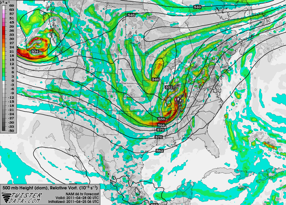
-
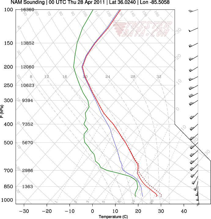
Yeah I was guessing that was where thewxmann pulled the crazy soundings. I saw those too earlier--interesting to see if/how that feature develops.
-
I don't think there is any "convective feedback" here. Typically convective feedback is produced by overcooked convection--usually in situations with massive CAPE fields and weak shear. Old GFS displayed that when it tried to develop sub-grid scale convection under those scenarios. Classic convective feedback is a mass amount of unrealistic latent heat released by the models in the mid-troposphere which then unrealistically warms the mid levels and cripples the dynamic/thermal fields. NAM/GFS had this on full display during the Groundhogs Day storm. The old GFS bullseyes in the VV/vorticity fields were another example.
-
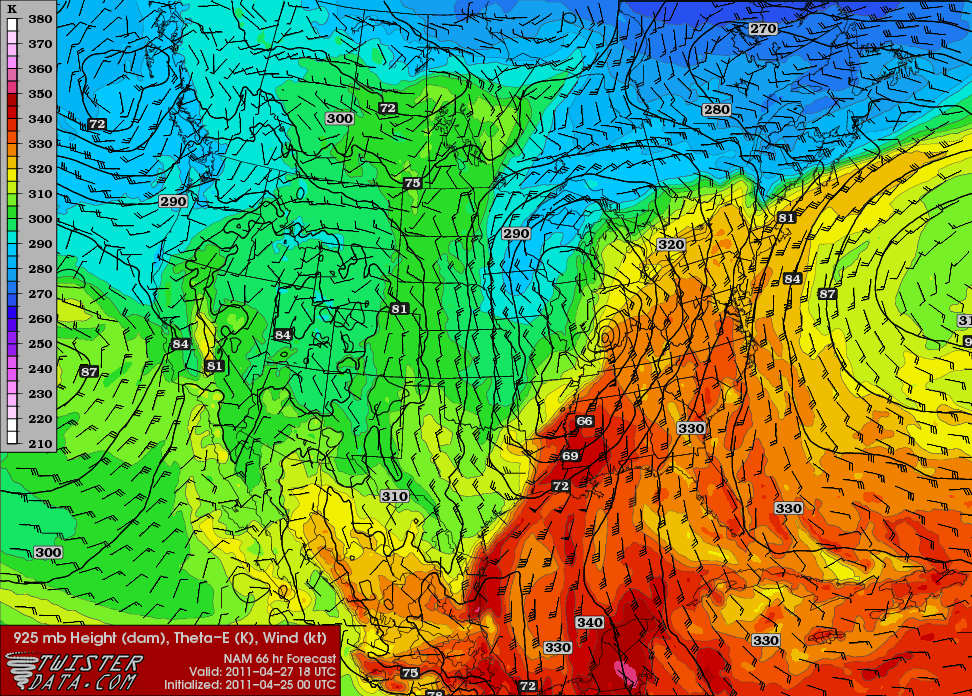
It is propagating along the warm front--you can see it in the theta-e fields. It is definitely feeding off the moist inflow. It is definitely convective in nature--no other way to explain 90 kt 850 wind fields. Oddly enough Euro, CMC, UK all suggest this type of feature.
-
Yeah I saw that too. Euro, CMC, UK and NAM all suggesting some sort of mesoscale complex rapidly propagating northward associated with that low amplitude leading wave ahead of the main anomaly overnight Tuesday into Wed and some sort of freak nasty theta-e inflow. Honestly never seen soundings or wind fields like that before.
-
What a complicated setup for each day through Thursday. Each event will have a cascading effect on both the synoptics as well as the storm environments. Not an easy set of forecasts for SPC or the local forecast offices.
-
Thanks for the info Fred. I won't lie I know little of southeast severe climo. I guess I was mostly referencing farther N, but all your points make good sense.
-
No I agree--but earlier guidance was much more energetic with the leading anomaly with more backed low level wind fields Wednesday. The flow aloft here may very well be even stronger than initially progged with this deamplifying trough--I was just thinking the ceiling is still slightly lower than earlier progged but still highly impressive with widespread significant potential.
-
Much easier to see the differences since yesterday in guidance doing it this way.
-
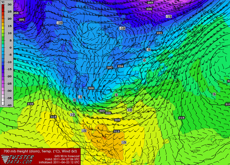
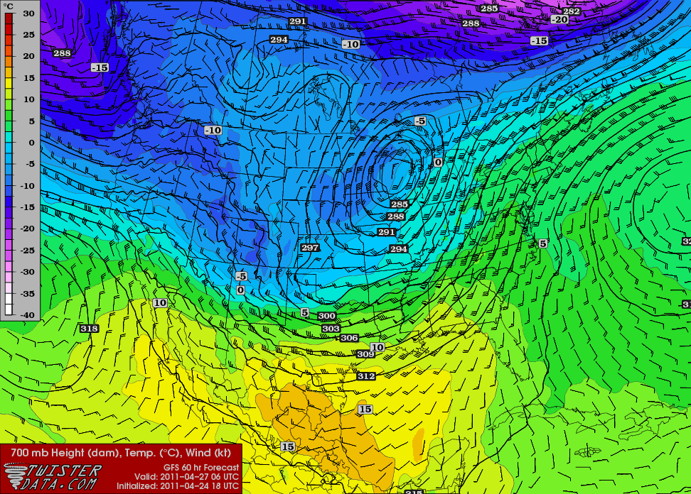
Totally agree. The first ejecting wave Monday night keeps trending deeper with faster height falls overspreading the warm sector. For whatever reason it seems some are dismissing Monday night when in reality it is looking like a highly active evening/overnight. Tuesday, looks interesting as CUmet stated, as the guidance has been trending towards a very shallow upper tropospheric wave ejecting ahead of the main anomaly. Slightly more zonal than a day before with the atmospheric response being faster/earlier height falls Tuesday evening and slightly less amplified/SW flow. Shows up nice on PV maps. And the corresponding height field response with greater mid level height falls/cooling than previously projected over much of Ark with initiation in the late afternoon and through the earlier evening. 18Z GFS at 60 hours: 12Z GFS yesterday at 12Z: By Wednesday, it is anyones best guess--but the consequence of that low amplitude leading wave Tuesday and a more zonal and less amplified flow in the overall trough means Wednesday may have a slightly lower ceiling than before although still very impressive. I agree that all three days have nearly equal potential now.
-
NAM it putting out some sort of freakish 90 KT winds below 800 hpa on Wednesday.
-
For now I am ok keeping all three in one. Monday-Tue-Wed will likely be three moderates in a row, possibly a high on Wed at some point. All three days have regions with significant potential although Tue/Wed look to be potentially very dangerous.
-
Don't believe that is free. Best you can get is 850 temps. I like using Chinooks page (AMWX poster) for the Euro since he did a nice job choosing colors/contours. http://www.greatlake...CMWF_plots.html
-
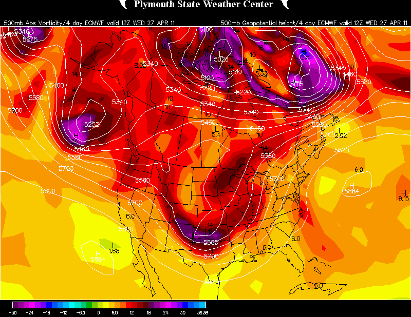
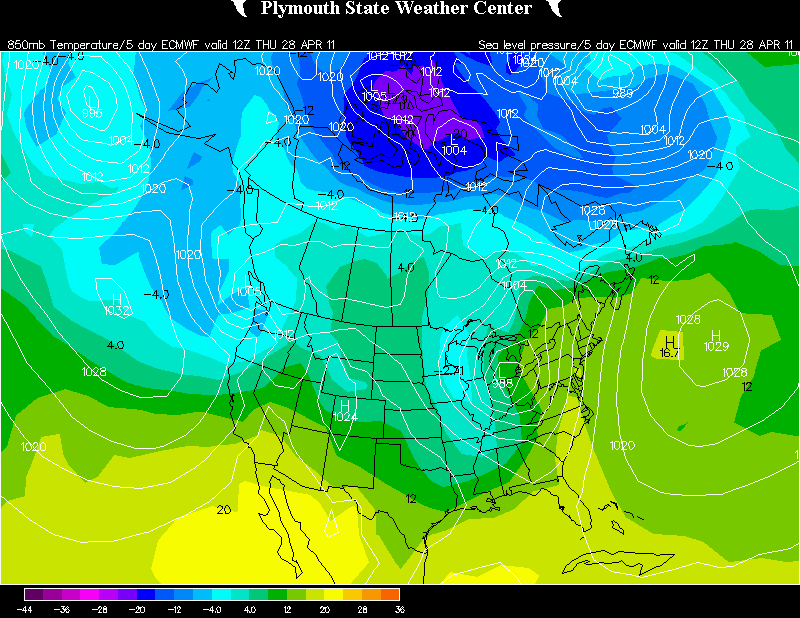
Euro Day 4 has a much more menacing look than the GFS as it ejects a much more E-W consolidated PV anomaly over the warm sector which would incite more vigorous lower tropospheric cyclogenesis than the GFS. The Euro is showing the potential for positive feedback as well as by day 5 the low is bent back much farther W than the GFS. Still too far out for details--but potential threats can be considered. It is worth mentioning the globals will also not be very indicative yet of feedback potential over a deep low troposphere exhibiting very low static stability/static instability. NAM/SREF/RGEM will catch that potential much better--similar to the 14th through the 17th outbreak (but mainly to the 14th when that intense anomaly ejected over the plains and the rapid tropospheric deep intensification that followed). Day5 850/SLP.
-
Yeah that is amazing for SREF at 87 hours.
-
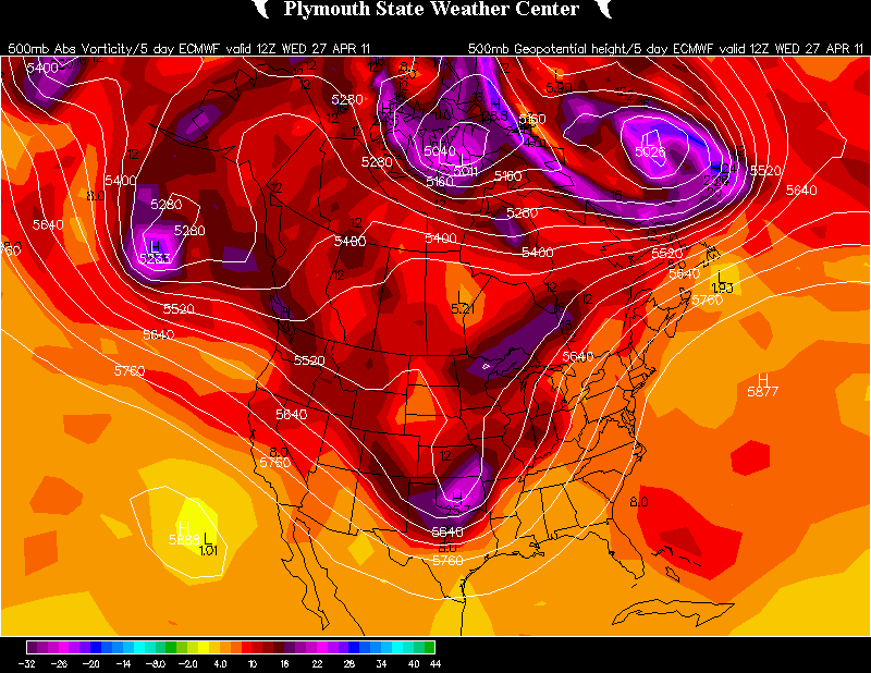
Day 5 Euro.
-
The medium range guidance as of the last 2 days or so has been more suggestive of the potential for the leading day 4 wave to kick out and eject faster. The result is more amplification/deepening potential of the secondary wave day 5+. Euro suggested that yesterday and now the GFS is suggesting that potential.
-
Congrats. We have a lot of met majors here. Opinions are great--but do remember SPC is not putting out outlooks and forecasts to appease their own storm chasing fantasies. Just remember that there are folks at SPC who are pioneers in the field of severe weather and severe weather forecasting. "makes no sense at all what they are doing" No--quoting Henry Margusity does not count towards providing your opinions.
-
Yes you told us what the operational models were already saying. There is far more to forecasting than that. Do remember we are talking Day 4-5+ here.
-
If you disagree--please provide your own reasoning/discussion for such disagreement. Do remember these are probabilistic outlooks which take into consideration many other factors besides the operational models alone.
-
Wow talk about a prolonged multi-day threat potential for significant severe weather. It has been a long time since I have seen that amplified of a flow pattern. Even with weak embedded anomalies in the flow (which as others have stated...will be difficult if not impossible to forecast at this juncture)--the jet pattern will be highly favorable as well. Definitely something to watch.
-
If you don't mind me asking--what office are you at and where did you start in private wx? I pretty did the same career move starting in private wx in Grand Forks, ND in road weather.
-
Agreed. I agree with your assessment that some of the best meteorologists I have met were non-American. Great mets come from everywhere , I guess. Perhaps a discussion for a different thread, but great minds come from all backgrounds.
-
Yeah I knew this may come up. I am not stereotyping. I am explaining my experiences, and that is how it was. Simple fact was they were amazing research students, and their overall math background was light-years beyond the rest. As for forecasting, the group I knew didn't even try forecasting since it wasn't at the top of their agenda. Could they if they did? I would bet yes, and quite easily. Did I stereotype? NO.