

TSSN+
-
Posts
2,673 -
Joined
-
Last visited
Content Type
Profiles
Blogs
Forums
American Weather
Media Demo
Store
Gallery
Posts posted by TSSN+
-
-
2 minutes ago, stormtracker said:
GFS keeps it close for the friday system
-
 8
8
-
-
Just now, Ji said:
Yeah, because somebody else said it was much drierFor most it is.


-
 1
1
-
-
Lost good amount of aerial qpf.


-
1
-
-
Gfs coming in much drier
-
2 minutes ago, mappy said:
My point and click has added sleet to my total. Not surprised. I’ve def lucked out before where I’ve stayed cold enough at the mid levels to stay all snow, but have also definitely lost qpf to sleet while the column cooled. Every bit of elevation helps in that regard, which is why places to my NW, like New Freedom, Manchester, etc. will do 2” or so better than me.
I only think that’s for the very first hour or so. If you look at the hourly it has one hour period of slight chance sleet.
-
2 minutes ago, psuhoffman said:
It dropped me from .51 to .47. I’m infuriated. Crap model.
Ji hack your account?
-
 2
2
-
-
Just now, bncho said:
Models are saying 3-6" but my gut is telling me 1-3". What should I believe?
How much for South Carolina?
-
1
-
-
1 minute ago, stormtracker said:
High was forecast at 47 (lol), made it to 39
41 up here
-
3 minutes ago, DDweatherman said:
Will the final spin be a good one? Will Ji be upset with his 3”? Will the ball land on zero and deliver an RGEM solution from yesterday? Will there be football banter also mentioned? Am I here bringing good luck from the great Keystone state? Will Randy have to skip mimosas this week?
Ready over here in the dump. Trash bag measuring system in place.
-
1 minute ago, Amped said:
I always get nervous in these anafront setups where we have to wait for cold air to come over the mountains. Models are usually too fast to cool things off. Hopefully we still get a decent event.
It’s not like we are in the 50s/60s today. Has to cool from the upper 30s
-
-
1 minute ago, psuhoffman said:
3k just spit out one of those euro almost non event solutions from yesterday. 12k still having convective issues.
On to the bigger guidance.
Of course can’t just have consistency 24hrs out
-
 1
1
-
-
3 minutes ago, mitchnick said:
That 4-day period, if true, would beat any consecutive 4-day period in 93/94.
Been a while since seen the rivers freeze up.
-
1
-
 1
1
-
-
Just now, Interstate said:
Is this just for reporting stations or can you do it for any location?
Mostly major cities or airports.
-
1
-
-
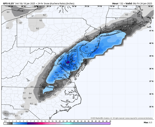
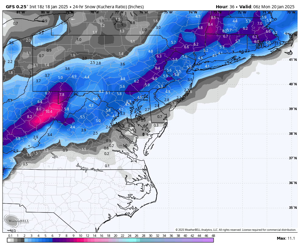
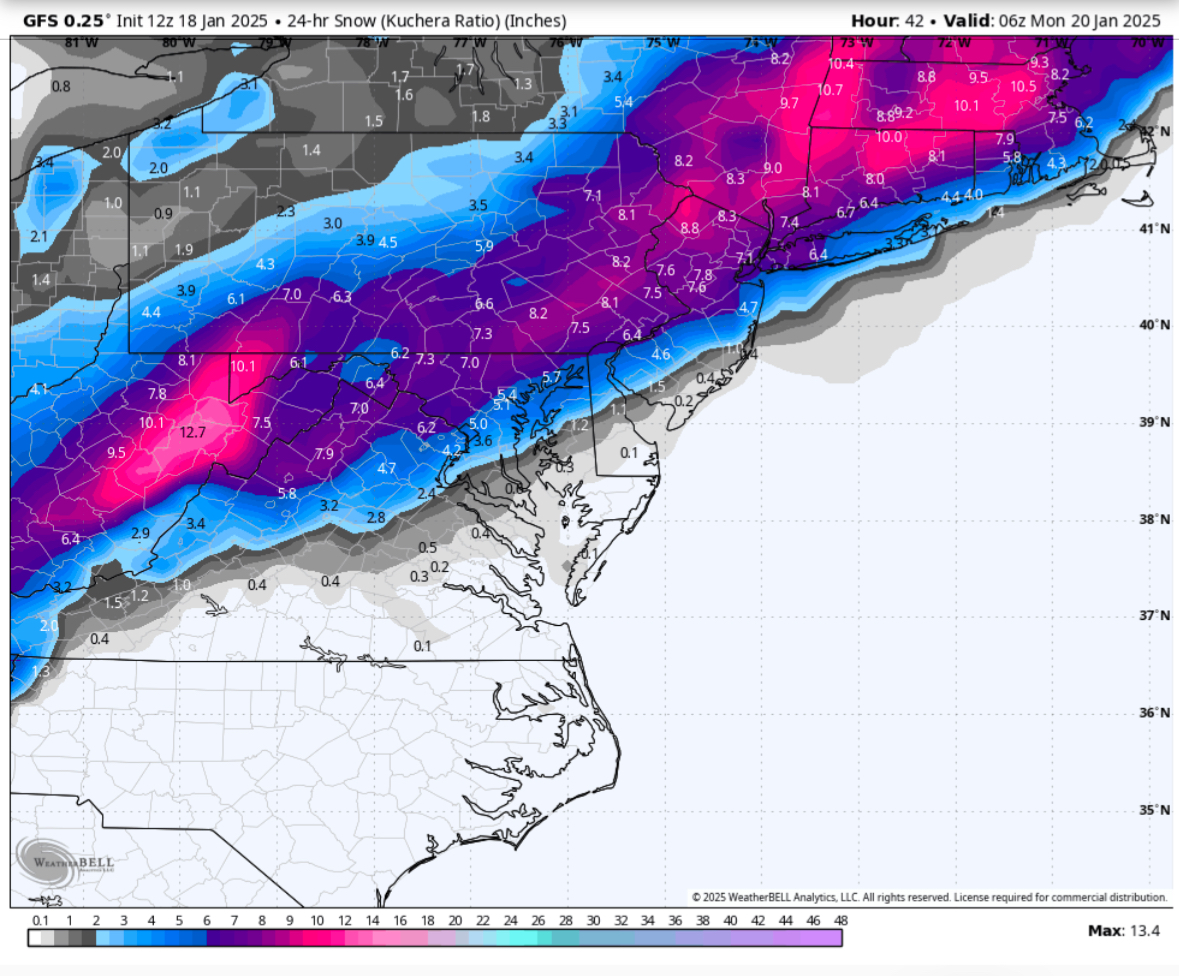
Behind this storm though. Holy hell.

-
3
-
-
Just now, Ralph Wiggum said:
Is anyone with access going to post the kuchie?

-
 1
1
-
-
1 minute ago, stormtracker said:
True. I mean, I get it. It's ok to be transparent. If I were you, I'd be pulling for the RGEM too. But it's on its own. Either it is gonna score a serious coup or it's gonna fall flat. I'd rather not have to rely on the R/GEM tho vs...everything else.
I don’t want the Rgem. Maybe if it was what it shows but like 75 miles south. Don’t want to be that close to the line.
-
1 minute ago, aldie 22 said:
Did you post the icon?
People already posted it before I even loaded it. But here ya go

-
2
-
1
-
-
Just now, winter_warlock said:
Cause he's in the snow zone on that map lol
Or I post every model?
-
3 minutes ago, stormtracker said:
He lives in a good spot on the RGEM
Or it’s an option just like the rest. I’d rather have the Nam or icon output.
-
Rgem not folding. 36hrs out

-
What am I even looking at?

-
2
-
 1
1
-
-
2 minutes ago, clskinsfan said:
0z HRRR starting to get a clue. Still bad. But not running the low up the Shenandoah Valley anymore.
Almost Rgem like.
-
1
-
-
Euro looking like the Nam before the Nam juiced up lol. So many ens members with nothing or even weaker than op. I think it’s out to lunch.


January Medium/Long Range: A snowy January ahead?
in Mid Atlantic
Posted
H5 doesn’t look bad. Hopefully it gets a little better and brings it up the coast more.