

JTA66
-
Posts
4,394 -
Joined
-
Last visited
Content Type
Profiles
Blogs
Forums
American Weather
Media Demo
Store
Gallery
Posts posted by JTA66
-
-
RGEM I-95 crush job
-
 1
1
-
-
I don’t think the punters are gonna see a lot of work tonight
-
 1
1
-
 1
1
-
-
I said 4” imby yesterday and I’ll ride with that.
-
5 hours ago, JTA66 said:
Yeah, but GFS close next Sunday/Mon. Verbatim NJ & DE see some action.
GFS trying at 126, has some light snow into SE PA.
What a sick hobby! Haven’t seen flake one from tomorrow’s storm and I’m already looking for the next one.

-
2
-
-
38F/DP 36F
Hopefully all downhill from here.
-
RGEM still tucked in, brings the low across the Delmarva.
-
 1
1
-
-
34 minutes ago, RedSky said:
Not 100% sure but think I heard thunder during last February's I78 death band that dumped mash potatoes for a couple hours
Was that 2011? Now that I think about it, it was a dynamic storm with rain changing to snow. There must have been thunder because a bunch of us were online debating if we were getting hail or sleet.
-
Had thunder snow with the 2006 storm.
-
2
-
-
Think we can get through the 1st quarter tomorrow without the announcers crying, “These are the same fans who threw snowballs at Santa in 1682.”??
-
3
-
 1
1
-
-
Yeah, but GFS close next Sunday/Mon. Verbatim NJ & DE see some action.
-
1
-
-
Give me the wrapped up RGEM solution with the NAM thermals. (I’m not greedy or anything.)
-
1
-
-
FV3 looks like a compromise between the RGEM & HRRR vs the NAM. In other words, we just can’t know!
-
1
-
-
36 minutes ago, PhiEaglesfan712 said:
The 2013 one is the closest to the conditions we will have on Sunday. That was the famous LeSean McCoy snow game, and Stafford's passing numbers were down that day, for what it's worth.
McCoy set the all time rushing yards by an Eagle in a single game that day.
Saquan broke that record against the Rams this year.
So there’s that
-
1
-
-
GFS looking good!
-
So we can put off talk about merging with the NYC forum for a few more weeks?
-
1
-
1
-
-
Now let’s get the RGEM to play nice.
Setting the over/under imby at 4”.
-
-
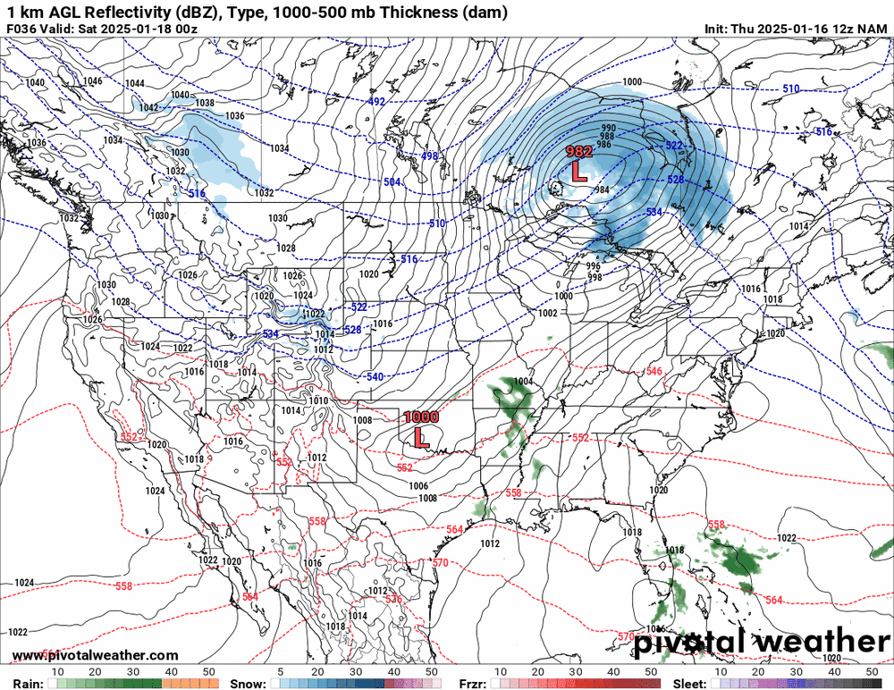
Looks like the NAM is kinda, sorta, almost getting a clue. 12K has some light precip over eastern areas as opposed to 300 miles OTS like yesterday.
-
19 minutes ago, Ralph Wiggum said:
Just read in another sub that half the eps members look like the NAM....a nothingburger. Luckily we are at a range where the ens are a little less dependent. I would venture to guess the NAM gives is a NAMming by 12z tomorrow at the latest. It is slowwwwwwly coming around.
If the NAM scores a coup over the Euro AI, I'll read every one of Albedoman's posts from start to finish.
-
1
-
4
-
 1
1
-
-
Some yellow snow around my fire hydrant this morning. Deep winter!
15F/DP 12F
-
1
-
-
First salt truck of the day. Bet they weren’t expecting to work tonight.
-
1
-
-
It's an official car topper here, 25F/DP 21F
-
Flurries are picking up in intensity. Getting a coating in the flower beds.
-
11 minutes ago, Hurricane Agnes said:
12z NAM is sliding the low sort of OTS from the Carolinas, so it swings and misses
 .
.
Isn't this the old "convective feedback" issue, where the NAM would jump the low out by the thunderstorms and not along the baroclinic zone close to the coast? We're still several days out, so who knows? Maybe the NAM at range is right...for once.
-
1
-
Sunday 1/19 Eagles Game Snow and Stuff
in Philadelphia Region
Posted
I’m far from the biggest Sirianni fan, but can we stop with the, “but Dan Campbell plays his starters in the preseason. Dan Campbell doesn’t rest his starters, they play all 17.”
Where is Detroit now? That teams is decimated by injuries and is one and done!
Go Birds!!