Siberian-Snowcover-Myth
-
Posts
291 -
Joined
-
Last visited
Content Type
Profiles
Blogs
Forums
American Weather
Media Demo
Store
Gallery
Everything posted by Siberian-Snowcover-Myth
-
January/February Mid/Long Range Disco IV: A New Hope
Siberian-Snowcover-Myth replied to stormtracker's topic in Mid Atlantic
You can likely shift that North about 500 miles. The SER will win out. -
January/February Mid/Long Range Disco IV: A New Hope
Siberian-Snowcover-Myth replied to stormtracker's topic in Mid Atlantic
Hope it’s not like last year when Texas froze and we barley saw any cold air from that arctic outbreak. -
I was wondering the same thing…. Seems the 540 doesn’t exist anymore.
-
My Daffodils are gonna love the watering over the next couple of weeks.
-
I could go for a good ole fashioned Alberta Clipper or Manitoba Mauler right now! Do they even exist anymore???
-
That’s a great look… if it holds true.?
-
January Mid/Long Range Disco 2
Siberian-Snowcover-Myth replied to WinterWxLuvr's topic in Mid Atlantic
The snowpack (or lack thereof) in the US. Talked to a friend in Cadillac Michigan who said there is no snow on the ground at all. It’s been warm most of the winter, in the 30s and 40’s. Folks up there are enjoying no snow, while we are here hoping to see blue on a model, 10 days out! So don’t give up hope, it’s not just the Mid Atlantic going through a snowless season.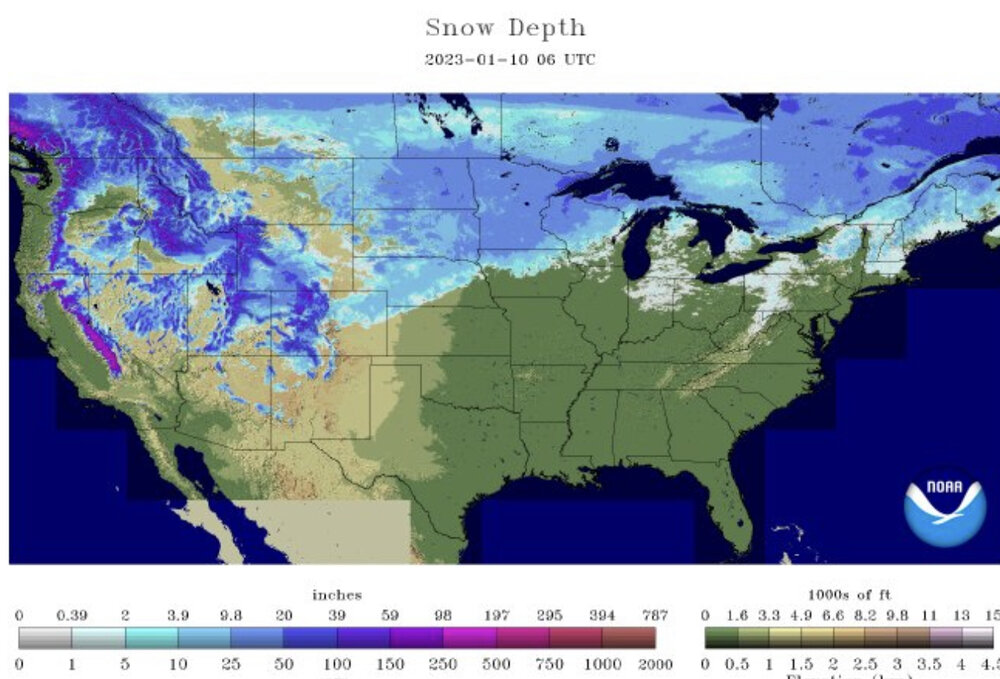
-
January Mid/Long Range Disco 2
Siberian-Snowcover-Myth replied to WinterWxLuvr's topic in Mid Atlantic
The 540 line isn’t even in this country. -
January Mid/Long Range Disco 2
Siberian-Snowcover-Myth replied to WinterWxLuvr's topic in Mid Atlantic
When the 540 line is near the Hudson Bay…. I’d say you’re right. -
January Mid/Long Range Disco 2
Siberian-Snowcover-Myth replied to WinterWxLuvr's topic in Mid Atlantic
Exactly -
January Mid/Long Range Disco 2
Siberian-Snowcover-Myth replied to WinterWxLuvr's topic in Mid Atlantic
Seems most of our storms aren’t picked up until 3/4 days out -
December 2022 Medium-Long Range Disco
Siberian-Snowcover-Myth replied to WxUSAF's topic in Mid Atlantic
Honestly I’d be happy with 2-4” and an arctic blast, for Christmas… meanwhile waiting on the 27th storm to arrive. -
December 2022 Medium-Long Range Disco
Siberian-Snowcover-Myth replied to WxUSAF's topic in Mid Atlantic
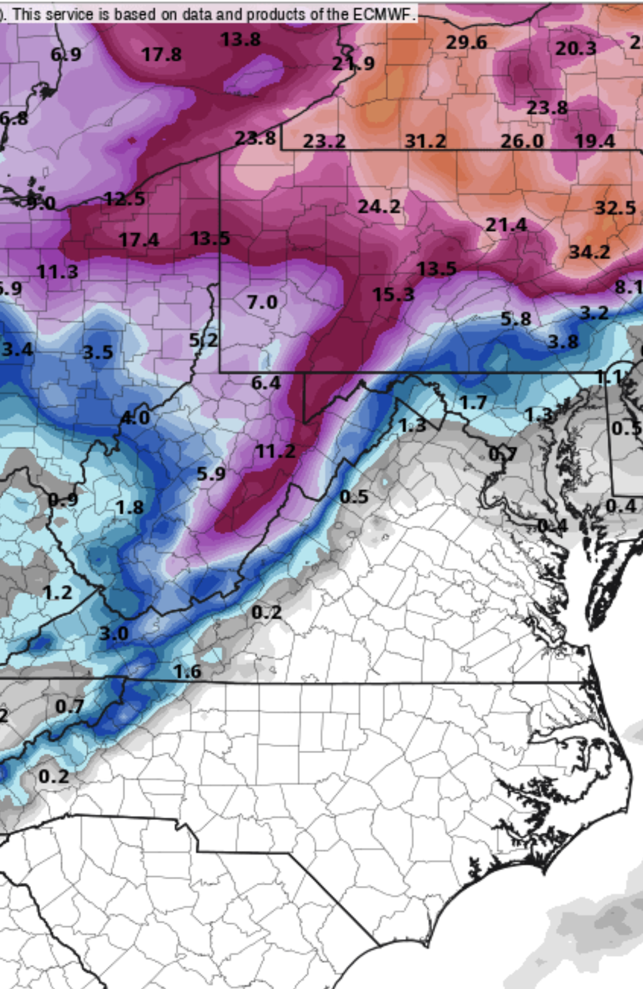
Total (kuchera) thru the 28th. Clown map but the 2nd storm on the 27th looked to be an extended training plume of moisture flowing in from the SW.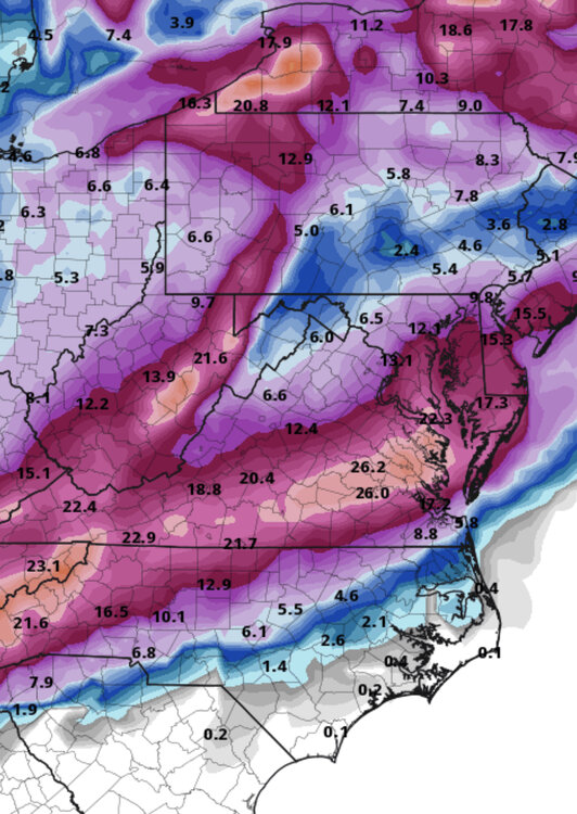
-
December 2022 Medium-Long Range Disco
Siberian-Snowcover-Myth replied to WxUSAF's topic in Mid Atlantic
Per GFS…Looks like the wave catches up too late. Start cranking just off shore. Eastern Va gets a good thumping. Still a week out, things can change.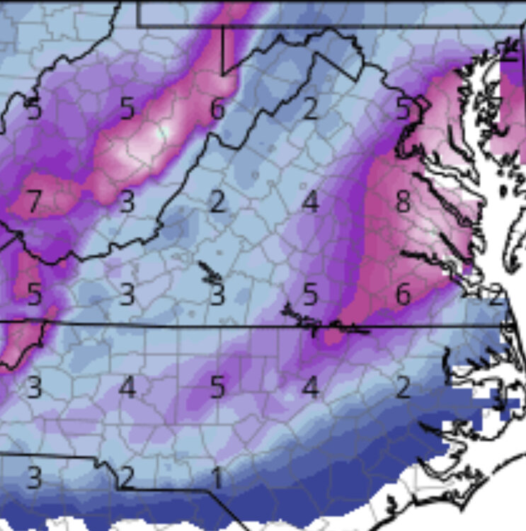
-
December 2022 Medium-Long Range Disco
Siberian-Snowcover-Myth replied to WxUSAF's topic in Mid Atlantic
The King Giveth…. The King Taketh.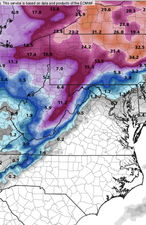
-
December 2022 Medium-Long Range Disco
Siberian-Snowcover-Myth replied to WxUSAF's topic in Mid Atlantic
Good thing most are asleep and didn’t see the Euro. -
December 2022 Medium-Long Range Disco
Siberian-Snowcover-Myth replied to WxUSAF's topic in Mid Atlantic
January 1987. -

-
Richmond Metro/Hampton Roads Discussion
Siberian-Snowcover-Myth replied to RIC Airport's topic in Mid Atlantic
Anybody here remember the Christmas ice storm of 1998. We lost power for 12 days here. It was a narrow swath that cut SW to NE across Richmond thru Henrico, Charles City and New Kent. Hopefully this won’t be as bad, but looking at these early models, has me worried. -
Jan 31 - Feb 1 Event - STORM MODE THREAD
Siberian-Snowcover-Myth replied to stormtracker's topic in Mid Atlantic
Might be the most ragged, epic storm in recent history. -
Typical Miller B Pennsylvania snowstorm.
-
January Storm Term Threat Discussions (Day 3 - Day 7)
Siberian-Snowcover-Myth replied to WxUSAF's topic in Mid Atlantic
Old Yeller > GFS -
January Storm Term Threat Discussions (Day 3 - Day 7)
Siberian-Snowcover-Myth replied to WxUSAF's topic in Mid Atlantic
Here we go again! -
January Storm Term Threat Discussions (Day 3 - Day 7)
Siberian-Snowcover-Myth replied to WxUSAF's topic in Mid Atlantic
Always thought it would end up being a blend of yesterdays Euro and yesterday’s GFS. Starting to head in that direction. I think sometime Sunday the gfs will start to cave. By late Monday there will probably be a much clearer solution. -
January Storm Term Threat Discussions (Day 3 - Day 7)
Siberian-Snowcover-Myth replied to WxUSAF's topic in Mid Atlantic
Not buying into the gfs until Tuesday. I’ll go with the Euro/Canadian until then. The gfs is having some serious issues analyzing its data.