

TauntonBlizzard2013
-
Posts
34,186 -
Joined
-
Last visited
Content Type
Profiles
Blogs
Forums
American Weather
Media Demo
Store
Gallery
Everything posted by TauntonBlizzard2013
-

"Don’t do it" 2026 Blizzard obs, updates and pictures.
TauntonBlizzard2013 replied to Ginx snewx's topic in New England
That was Jan 22. This beats that. I didn’t really complain about this. Mid week it looked like a miss. -
"Don’t do it" 2026 Blizzard obs, updates and pictures.
TauntonBlizzard2013 replied to Ginx snewx's topic in New England
Some of the short range guidsnce suggesting an additional 3-5” here -
"Don’t do it" 2026 Blizzard obs, updates and pictures.
TauntonBlizzard2013 replied to Ginx snewx's topic in New England
It’s like cement. Snowblower really struggling -
"Don’t do it" 2026 Blizzard obs, updates and pictures.
TauntonBlizzard2013 replied to Ginx snewx's topic in New England
It’s going to be days to dig out here. -
"Don’t do it" 2026 Blizzard obs, updates and pictures.
TauntonBlizzard2013 replied to Ginx snewx's topic in New England
Executive order travel ban in Bristol Plymouth and Bars table counties. Cars stuck on 24 and 495. -
"Don’t do it" 2026 Blizzard obs, updates and pictures.
TauntonBlizzard2013 replied to Ginx snewx's topic in New England
-
"Don’t do it" 2026 Blizzard obs, updates and pictures.
TauntonBlizzard2013 replied to Ginx snewx's topic in New England
Going to be impossible to get a true measurement here, but I’d say it’s over 30 easy -
"Don’t do it" 2026 Blizzard obs, updates and pictures.
TauntonBlizzard2013 replied to Ginx snewx's topic in New England
Truly never see. Anything like this. Someone is going to make a run at 40 -
"Don’t do it" 2026 Blizzard obs, updates and pictures.
TauntonBlizzard2013 replied to Ginx snewx's topic in New England
Probably 2-3” an hour currently. Plows being pulled off the roads -
"Don’t do it" 2026 Blizzard obs, updates and pictures.
TauntonBlizzard2013 replied to Ginx snewx's topic in New England
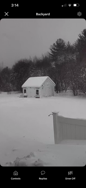
Took me an hour to get my snowblower from my shed to driveway. Going to take days to dig out. Never seen anything like this. literally had to wade through chest deep snow to get to the shed -
"Don’t do it" 2026 Blizzard obs, updates and pictures.
TauntonBlizzard2013 replied to Ginx snewx's topic in New England
Might snow through 8-9 pm, at lesser intensity of course -
"Don’t do it" 2026 Blizzard obs, updates and pictures.
TauntonBlizzard2013 replied to Ginx snewx's topic in New England
Sim radar has this band pivoting around and west of Boston and slowerly tapering off. Boston points south could still be snowing at 8pm -
"Don’t do it" 2026 Blizzard obs, updates and pictures.
TauntonBlizzard2013 replied to Ginx snewx's topic in New England
We’ll see how long this lasts -
"Don’t do it" 2026 Blizzard obs, updates and pictures.
TauntonBlizzard2013 replied to Ginx snewx's topic in New England
Low 30s? Not sure what 78 was here -
"Don’t do it" 2026 Blizzard obs, updates and pictures.
TauntonBlizzard2013 replied to Ginx snewx's topic in New England
Of course, wouldn’t anyone? This is going to take days to cleanup. Plows retreated in my immediate area. Probably goi by to need a front end loader now -
"Don’t do it" 2026 Blizzard obs, updates and pictures.
TauntonBlizzard2013 replied to Ginx snewx's topic in New England
This is going to be the all time storm for this area I think -
"Don’t do it" 2026 Blizzard obs, updates and pictures.
TauntonBlizzard2013 replied to Ginx snewx's topic in New England
We’re going to cruise past 30. Someone might see 40 -
"Don’t do it" 2026 Blizzard obs, updates and pictures.
TauntonBlizzard2013 replied to Ginx snewx's topic in New England
This is truly insane -
"Don’t do it" 2026 Blizzard obs, updates and pictures.
TauntonBlizzard2013 replied to Ginx snewx's topic in New England
Can’t even open my front door. Must be at around 2 feet -
"Don’t do it" 2026 Blizzard obs, updates and pictures.
TauntonBlizzard2013 replied to Ginx snewx's topic in New England
Just woke up. Visibility is feet, all windows are pasted with snow. Can’t see shit -
"Don’t do it" 2026 Blizzard obs, updates and pictures.
TauntonBlizzard2013 replied to Ginx snewx's topic in New England
Nasty out -
"Don’t do it" 2026 Blizzard obs, updates and pictures.
TauntonBlizzard2013 replied to Ginx snewx's topic in New England
Not doing much -
“Cory’s in NYC! Let’s HECS!” Feb. 22-24 Disco
TauntonBlizzard2013 replied to TheSnowman's topic in New England
You guys have been mocking me relentlessly. Cant take a little back? -
"Don’t do it" 2026 Blizzard obs, updates and pictures.
TauntonBlizzard2013 replied to Ginx snewx's topic in New England
What is eroding? Good luck to y’all? . What are you expecting there, 6 inches? -
“Cory’s in NYC! Let’s HECS!” Feb. 22-24 Disco
TauntonBlizzard2013 replied to TheSnowman's topic in New England
Nice 1/3 cut


