NycStormChaser
-
Posts
2,374 -
Joined
-
Last visited
Content Type
Profiles
Blogs
Forums
American Weather
Media Demo
Store
Gallery
Everything posted by NycStormChaser
-
August 2019 General Discussions & Observations Thread
NycStormChaser replied to bluewave's topic in New York City Metro
Hrrr says no but you never know. -
August 2019 General Discussions & Observations Thread
NycStormChaser replied to bluewave's topic in New York City Metro
First time I've seen a clap of thunder set off car alarms -
August 2019 General Discussions & Observations Thread
NycStormChaser replied to bluewave's topic in New York City Metro
Yeah I would not call it a bust to be honest. If the models DID NOT correct themselves leading up to yesterday then it would be a bust in my opinion. As others said the euro picked up on this. The NAM and the HRRR also picked up on it monday night as well. By yesterday morning the writing was on the wall before the event even started. The models are only tools. -
August 2019 General Discussions & Observations Thread
NycStormChaser replied to bluewave's topic in New York City Metro
Baby storm heading for the city with some lightning. -
August 2019 General Discussions & Observations Thread
NycStormChaser replied to bluewave's topic in New York City Metro
We may actually have more storms tomorrow morning than we did today. -
August 2019 General Discussions & Observations Thread
NycStormChaser replied to bluewave's topic in New York City Metro
You should have seen may 20th when I was chasing in Oklahoma. It was a high risk day by the spc. We saw a tornado but the high risk did not come close to verifying. -
August 2019 General Discussions & Observations Thread
NycStormChaser replied to bluewave's topic in New York City Metro
Agreed. It should be canceled at this point. The models handled this setup poorly. Unfortunately it happens from time to time. -
August 2019 General Discussions & Observations Thread
NycStormChaser replied to bluewave's topic in New York City Metro
Thunderstorms and flash flooding aren't out of the question today for our area. Wait until the event is over before calling a bust. -
August 2019 General Discussions & Observations Thread
NycStormChaser replied to bluewave's topic in New York City Metro
What do you mean? They did cut back on the northern extent of the slight and marginal. The writing was on the wall yesterday -
August 2019 General Discussions & Observations Thread
NycStormChaser replied to bluewave's topic in New York City Metro
I think they tighten up the northern extent of the marginal and slight -
August 2019 General Discussions & Observations Thread
NycStormChaser replied to bluewave's topic in New York City Metro
I'm likely heading to SEPA for the chance of tornadoes. Might be a bit further south but it's definitely on the table IMO -
August 2019 General Discussions & Observations Thread
NycStormChaser replied to bluewave's topic in New York City Metro
Certainly not something you see often in the Northeast. Tornado: 5% - Slight Wind: 30% - Enhanced Hail: 15% - Slight -
August 2019 General Discussions & Observations Thread
NycStormChaser replied to bluewave's topic in New York City Metro
All modes of severe weather are possible Tuesday including tornadoes. I think the Philly area will be the center point and the slight risk may shift north. Wouldnt be surprised to see an enhanced risk Tuesday either if the forecast models hold its current course. -
August 2019 General Discussions & Observations Thread
NycStormChaser replied to bluewave's topic in New York City Metro
Tuesday looks like our next chance for severe weather. Does not look like a bad setup either. -
August 2019 General Discussions & Observations Thread
NycStormChaser replied to bluewave's topic in New York City Metro
Last evenings Aurora Borealis from the Adirondacks. Violet colored pillars filled the night sky as a weak geometric solar storm affected Earth. This was a new photography spot and dealing with the light pollution was very challenging. -
August 2019 General Discussions & Observations Thread
NycStormChaser replied to bluewave's topic in New York City Metro
Keep your eyes to the sky tonight if you live in some of our dark northern suburbs. The Aurora Borealis may make an appearance. It's only forecasted to be a KP5 but it does surprise us sometimes. I will be photographing it from the Adirondacks if it makes an appearance -
August 2019 General Discussions & Observations Thread
NycStormChaser replied to bluewave's topic in New York City Metro
We will see. Both the HRRR and 3kNAM have storms across the NYC Metro today. 3k NAM is more aggressive. Storms already firing up with some hail in the Hudson Valley. -
August 2019 General Discussions & Observations Thread
NycStormChaser replied to bluewave's topic in New York City Metro
Most of areas that saw storms last night should see them storms again this evening. -
Well supposedly the tow line broke but who knows. The last I heard the state may keep it.
-
This boat washed up at field 6 Jones Beach a few days ago. I went there last night to photograph it. I was surprised how dark it was that close to the light pollution.
-
I put together some of the best timelapse sequences I shot during my storm chasing trip a few weeks ago. I will have a second video coming this week that is more of a behind the scenes chase video.
-
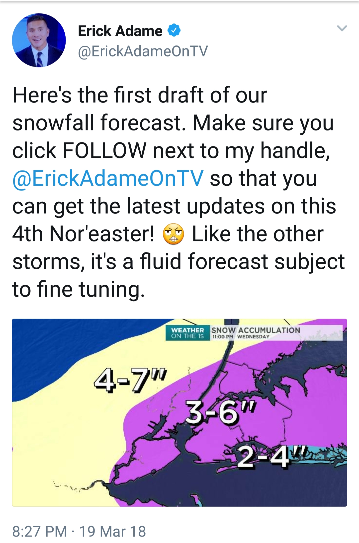
Vendor, Blog and TV Channel Forecasts Thread Part 2
NycStormChaser replied to Rjay's topic in New York City Metro
NY1...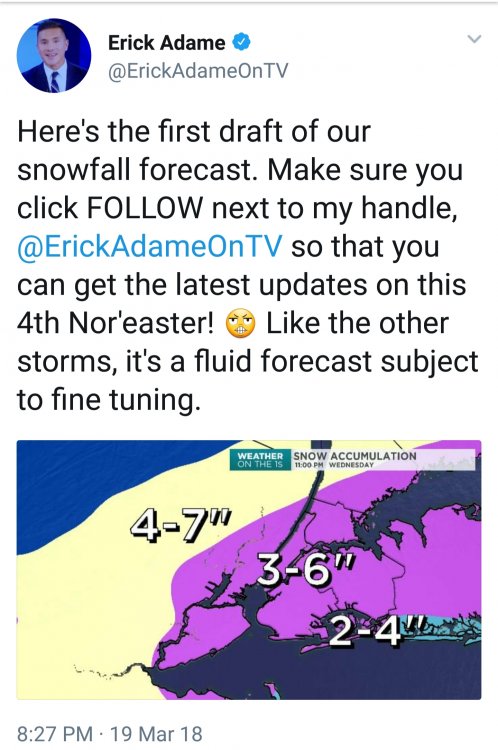
-
Pam. Not William.
-
Give it up already dude
-
.....