Sydney Claridge
-
Posts
532 -
Joined
-
Last visited
Content Type
Profiles
Blogs
Forums
American Weather
Media Demo
Store
Gallery
Everything posted by Sydney Claridge
-
That line east of Shreveport may be encountering storm relative helicity of up to 700m^2/s^2 per SPC Mesoanalysis.
-

Easter Weekend Severe Thread
Sydney Claridge replied to janetjanet998's topic in Central/Western States
New tornado warning includes Leander and Cedar Park. This is very concerning now that highly-populated areas are in the path. -
Easter Weekend Severe Thread
Sydney Claridge replied to janetjanet998's topic in Central/Western States
Uptick in precipitation cores over Parker, Tarrant, and Hood counties could be a problem for DFW if they intensify. All the precipitation in the area should be stabilizing things, but SPC Mesoanalysis still indicates plenty of CAPE in the region. Not thinking too much of it though. There may even be twin tornadoes south of Marble Falls. Two tight couplets are showing up on radar velocity. -
Easter Weekend Severe Thread
Sydney Claridge replied to janetjanet998's topic in Central/Western States
Right turn in the storm approaching Round Mountain could be a problem for the northernmost suburbs of the Austin area (especially Leander and Georgetown) if it continues on this track. -
Easter Weekend Severe Thread
Sydney Claridge replied to janetjanet998's topic in Central/Western States
Correlation coefficient suggests tornado on ground E of Eckert, TX. -
Easter Weekend Severe Thread
Sydney Claridge replied to janetjanet998's topic in Central/Western States
That cell definitely seems to be falling apart. It is no longer severe-warned. Question is if less convection tonight means there will be less junk convection across the southeast during the day tomorrow. Though I guess that could depend on the forward motion of the “main round” to develop in the next few hours. -
Easter Weekend Severe Thread
Sydney Claridge replied to janetjanet998's topic in Central/Western States
The supercell just north of Uvalde seems to have taken somewhat of a left turn, now aiming it towards the San Antonio metro area, provided that it holds together and remains on this track. The most intense part of the storm is probably about halfway between Del Rio and San Antonio now, though I would not expect the storm to impact the San Antonio area until after 12am (likely sometime after that). -
Easter Weekend Severe Thread
Sydney Claridge replied to janetjanet998's topic in Central/Western States
Additional convection is now going up, behind the initial supercell, from around Langtry, TX south to the Serranias del Burro. Unfortunately it is going to be difficult to clearly see any rotation on the initial supercell near Brackettville as it passes near/over the radar site. Radar imagery should get better again once the storm approaches the east end of the current warning polygon (provided that severe weather doesn't damage the radar, of course). -
Easter Weekend Severe Thread
Sydney Claridge replied to janetjanet998's topic in Central/Western States
Updated image just came out from SPC Mesoanalysis. The rapid increase in effective SigTor values is apparent just across the Mexican border: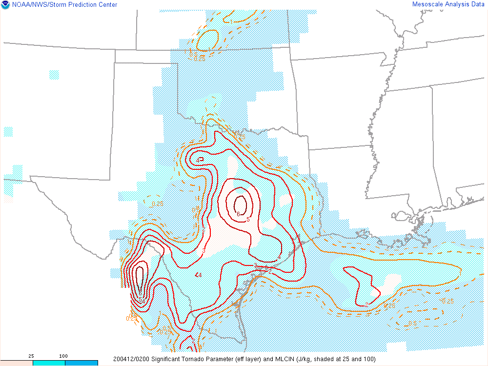
-
Easter Weekend Severe Thread
Sydney Claridge replied to janetjanet998's topic in Central/Western States
Yikes, RAP has the effective SigTor values exploding west of San Antonio over the next few hours. Another plume of increased effective SigTor is apparent moving towards DFW. This does not mean that storms will exploit this, especially for DFW, but San Antonio might as well be playing with fire given that storms might actually exploit those SigTor values down that way. Might be a different story for DFW if that storm west of Mineral Wells holds together, but that seemed to weaken once it hit the cooler airmass. -
Easter Weekend Severe Thread
Sydney Claridge replied to janetjanet998's topic in Central/Western States
That's what I was thinking. It would need to follow US-90 for that to happen though; if the storm continues to take a right turn it might pass just south of the metro if it holds together. Even if it took somewhat of a left turn relative to the US-90 corridor (that's doubtful), San Antonio sprawls out much more to the north than to the south. The most intense part of the storm is still about 40 minutes from Brackettville; eastward motion is only 25 mph. San Antonio has several hours before this particular storm hits, but if anything develops ahead of this they could get storms sooner. -
Easter Weekend Severe Thread
Sydney Claridge replied to janetjanet998's topic in Central/Western States
Here’s the couplet near Del Rio. If anything, that RFD looks pretty strong. Probably had some strong winds in Ciudad Acuña with that activity.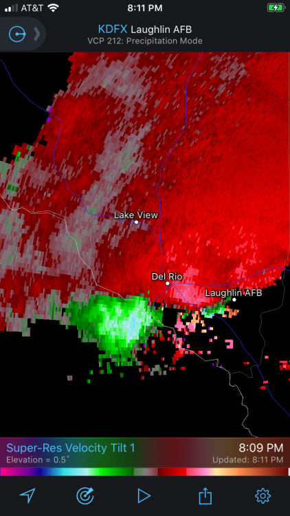
-
Easter Weekend Severe Thread
Sydney Claridge replied to janetjanet998's topic in Central/Western States
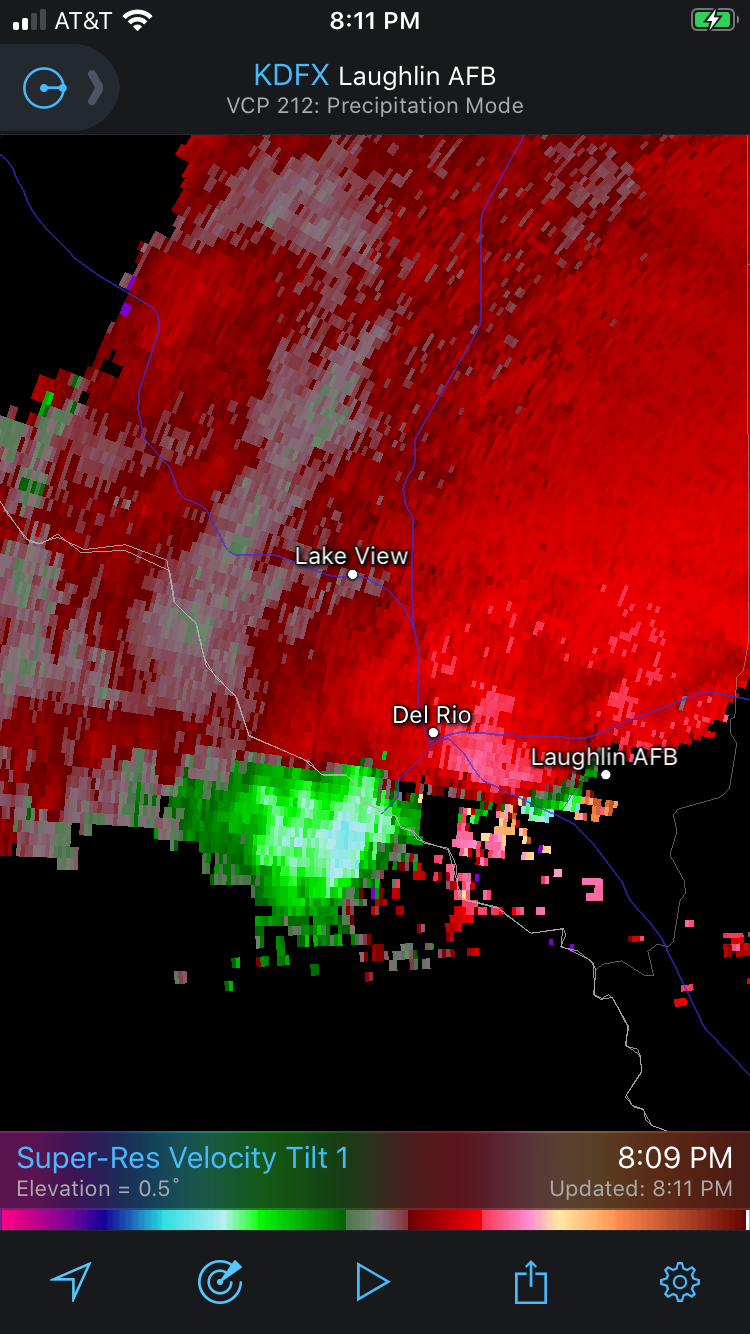
It also looks as if there is a possible couplet just SW of Del Rio based on velocity data. Given storm motions, this area of rotation will go right over Del Rio. No tornado warning at this time though. -
Easter Weekend Severe Thread
Sydney Claridge replied to janetjanet998's topic in Central/Western States
The severe thunderstorm warning for Del Rio and points north is now up. The storm is warned for 1.25 inch hail and 60 mph wind gusts. -
Easter Weekend Severe Thread
Sydney Claridge replied to janetjanet998's topic in Central/Western States
There is a huge storm coming into the north side of the Del Rio area right now. The storm core is still on the Mexican side of the border, but I'm surprised that there is not a severe thunderstorm warning out already given the proximity. We are getting some rain right now, so that might have a stabilizing effect. Interestingly enough the area of rain seems to be under the cloud debris from the storms that went up down by San Angelo. Many years ago I remember how anvil rain eroded a cap over the Metroplex and caused supercells to form unexpectedly; not expecting tonight will be like that though. -
Easter Weekend Severe Thread
Sydney Claridge replied to janetjanet998's topic in Central/Western States
Big hook between Lueders and Albany. Artifacts on the KDYX radar near the radar site might make the strength of the rotation look stronger that it actually is, but I would not be surprised to see a tornado warning if the rotation strengthens. EDIT: good news is that the rotation looks pretty ragged as it moves into Albany. This could change, however. -
Easter Weekend Severe Thread
Sydney Claridge replied to janetjanet998's topic in Central/Western States
The storm over Lueders seems to be developing a hook and may be showing signs of strengthening rotation. Any rotation that develops out of this storm could move closer to (or even over) Albany. I do not want to see this happen seeing that Albany got hit with a tornado less than a month ago on March 19th. -
Easter Weekend Severe Thread
Sydney Claridge replied to janetjanet998's topic in Central/Western States
What's crazy is that area near Albany was hit with tornadoes just a few weeks ago. -
Easter Weekend Severe Thread
Sydney Claridge replied to janetjanet998's topic in Central/Western States
There's definitely a push of warmer, more humid air towards the DFW Metroplex now. Cleburne is now reporting 70 with a dewpoint of 66, and Waxahachie has now warmed to near 70 (they were in the cold pool earlier). Those severe storm parameters (EHI, SigTor, Supercell composite, etc.) are starting to creep northwards. If this airmass pushes any further north (and it will), provided we get storms tonight, that might be cause for concern, especially if a boundary is in the vicinity. -
Easter Weekend Severe Thread
Sydney Claridge replied to janetjanet998's topic in Central/Western States
Also watch that storm SW of the tornado-warned storm near Haskell. That severe-warned storm E of Roby looks like it is trying to form a hook as well. Rotation does not look as good at this time, though. EDIT: well it looked like it was developing a hook. Seems less obvious now. EDIT 2: the hook is back. -
Easter Weekend Severe Thread
Sydney Claridge replied to janetjanet998's topic in Central/Western States
Agreed. Definitely some rotation trying to form on it. The question is how long these storms can remain intense with eastward extent, given the cooler temperatures further east. You have mid-70s temperatures at Haskell, but two counties east at Graham, the temperature is in the upper-60s. That said, areas to the east are warming and moistening as the cold pool from the earlier convection tries to erode. Seems like that cold pool is persistently stubborn, especially just south of DFW, where Waxahachie continues to report 63F, but just south of there temperatures seem a lot warmer; Hillsboro is in the lower-70s. And there is another severe-warned storm north of Ardmore, OK as well. -
Easter Weekend Severe Thread
Sydney Claridge replied to janetjanet998's topic in Central/Western States
I'm awaiting the results of the 18z HRRR run, but the 17z run puts a big storm through the DFW area between 9-10pm (16z run also shows a big storm, and 15z shows lesser storms). That said, HRRR is showing warmer temperatures than what we are actually observing at the present moment though (currently 66F in Fort Worth, but 17z HRRR projected 70 to 71F by now). Once this cold pool shifts northeast, the Metroplex may try to destabilize (though the cloud cover seems to be hampering things a little bit), and the boundary left behind is always a concern if a storm comes into proximity with it. EDIT: 18z run did back off on placing storms in the DFW area. -
Easter Weekend Severe Thread
Sydney Claridge replied to janetjanet998's topic in Central/Western States
You don’t see hatching on a 15% wind risk that often, as SPC has out now up to and SW of San Antonio; most times hatched wind is not seen unless there is a 30%+ wind risk. Looks like the more intense storms could initiate around the Serranias del Burro of northern Mexico. I also got a quick-hitting convective shower at my location. The question is how much of a cold pool these storms over N TX are leaving behind. There is a prominent cold pool (lower 60s temperatures) just south of the Metroplex, and a lesser cold pool just to the NW of the Metroplex, but most DFW-area temperatures (except for Denton and Waxahachie) are in the mid-60s. The urban heat island could account for this, but the more intense storm cores went south and NW of the center of the Metroplex. SPC did trim the ENH risk further SW from N TX, however. Convective initiation is also underway SE of Lubbock at this time. -
Easter Weekend Severe Thread
Sydney Claridge replied to janetjanet998's topic in Central/Western States
The field of agitated cumulus south of Lubbock could evolve into one of the severe storm threats later today, as it moves east. This is where the CAMs suggested convective activity would initiate later, but said models did not predict the activity currently over north Texas (earlier NAM3k runs did, but more widespread than current observations). Outside of the larger storms near Graham and the complex NW of Waco, the current convective activity over north Texas seems to be doing very little to suppress insolation in the surrounding area (there is still plenty of sunshine at my location in west Fort Worth for instance), although satellite imagery does show cloudier conditions behind this activity. The back edge of this activity also looks to be a straight line from Waco to Graham, with almost nothing behind that. Unless we get additional convective activity immediately behind this, I think north-central Texas ends up seeing a good amount of surface-based instability this afternoon. What to watch for is if this initial convective activity lays down any outflow boundaries that Round 2 could exploit. -
Easter Weekend Severe Thread
Sydney Claridge replied to janetjanet998's topic in Central/Western States
This leading convective activity from west of Waco to northeast of Abilene may put a wrench into any possible model solutions for today. Even the NAM3k backed off on showing widespread morning convection. But it is all moving northeasterly, and the warm, moist airmass lies to the west of these initial elevated storms. Unless more widespread convection develops in the wake of these storms, I would not be surprised to see surface instability move in after the passage of these storms. If surface temperatures and dewpoints were higher, I would be much more concerned with severe storm activity, especially considering that I am seeing sunshine here in west Fort Worth. That said, the storm north of Albany, TX could also be on the verge of turning severe for large hail. EDIT: it just went severe for up to half-dollar sized hail and 60 mph wind gusts.