

Sydney Claridge
-
Posts
507 -
Joined
-
Last visited
Content Type
Profiles
Blogs
Forums
American Weather
Media Demo
Store
Gallery
Posts posted by Sydney Claridge
-
-
I've updated the title to account for the Slight risk for today (April 29) in Texas as well as the broad Slight risk on Wednesday (May 1) as well. Where I'm at (DFW) seems like our highest risk is going to be Wednesday, per the SPC outlook, unless something drastically changes for tomorrow.
-
Day 3 Slight but over a broader area than previous outlooks:
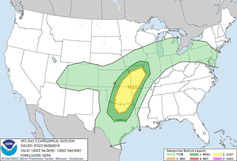
Seems like the threat area is shifting northeast per SPC. -
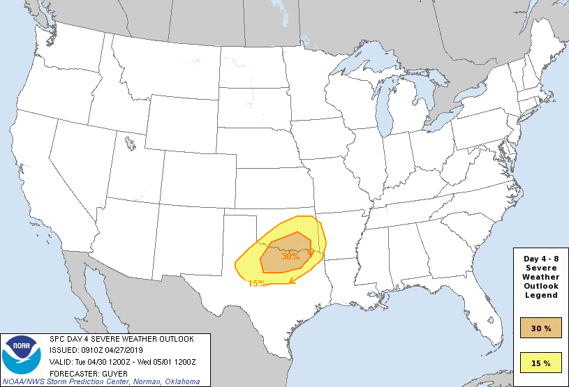
And now SPC has a Day 4 30% risk area out for North Texas (including DFW) and southern Oklahoma. Starting to wonder if this might be a significant event for someone in or near the DFW area.
-
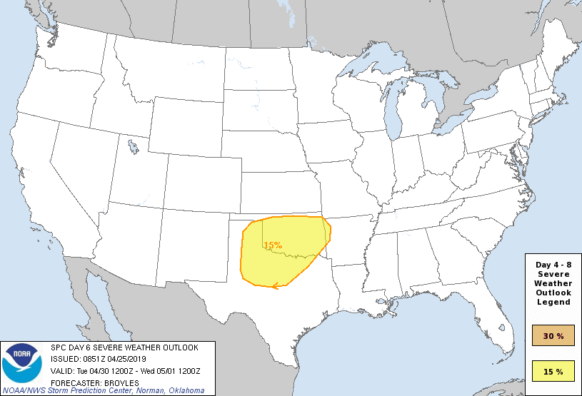
SPC has introduced an outlined area for Day 6:
The GFS-based models have quite a moist airmass over the warm sector (mid-60s to lower-70s dewpoints), but upper level support, in terms of the jet stream winds, seems a little lacking except across northern OK and southern KS from what I can tell (0z FV3 has the warm sector well into KS, while the 0z regular GFS keeps KS in the cool sector). -
And a severe thunderstorm warning in Tarrant County as well. I'm starting to hear the rain pick up here on the west side of Fort Worth, but the winds don't seem too strong right now. Storm is warned for 65 mph wind gusts.
-
3 minutes ago, cheese007 said:
Line full of severe storms now. Looks like it may bisect the DFW area though thanks to that break but we will see
That said, I believe those storms may have a northeasterly motion, so DFW may indeed get hit by storms.
-
It seems that the echo tops and radar returns estimated by the DFW radar have increased on that area of precipitation near Hico and Meridian; let's see if this is trying to initiate into something.
-
It looks pretty minor on radar right now, but I wonder about that little area of precipitation around Hico and Meridian right now, though it looks like it is struggling. If it can initiate into something bigger, on the track the storms seem to be taking, it could be a threat to DFW later on. Otherwise, it looks like DFW may have to wait for the storms that are currently down around Brownwood, unless something else tries to fire up. I've also noticed light radar returns over Parker County and have been wondering if they represent some sort of wind shift or boundary; there also seems to be some sort of boundary about midway between Breckenridge and Mineral Wells.
-
Surface CAPE has also rapidly increased (3000-3500 J/kg) and so has the MLCAPE (2000-2500 J/kg) per SPC Mesoanalysis for Fort Worth and Tarrant County. Once this cap breaks I have a feeling there could be some big storms.
-
Got some good clearing (partly cloudy) here in Fort Worth. Now it’s just a matter of waiting for the storms to fire up I guess.
-
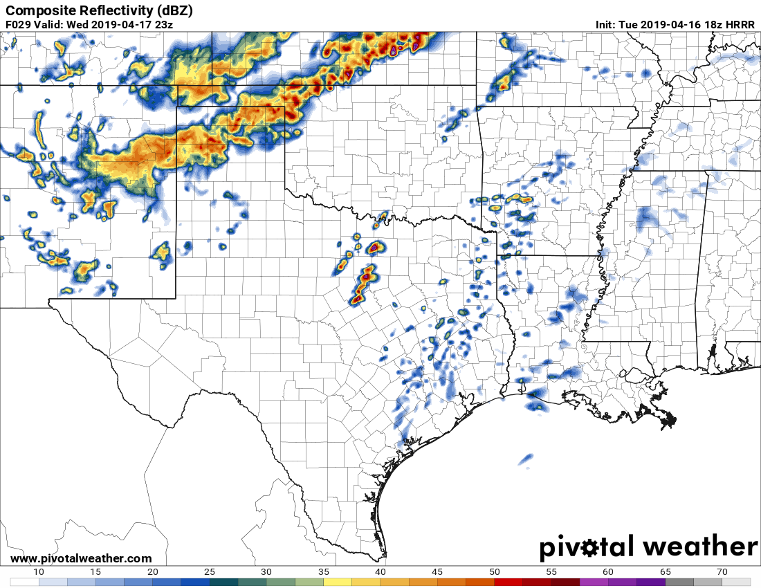
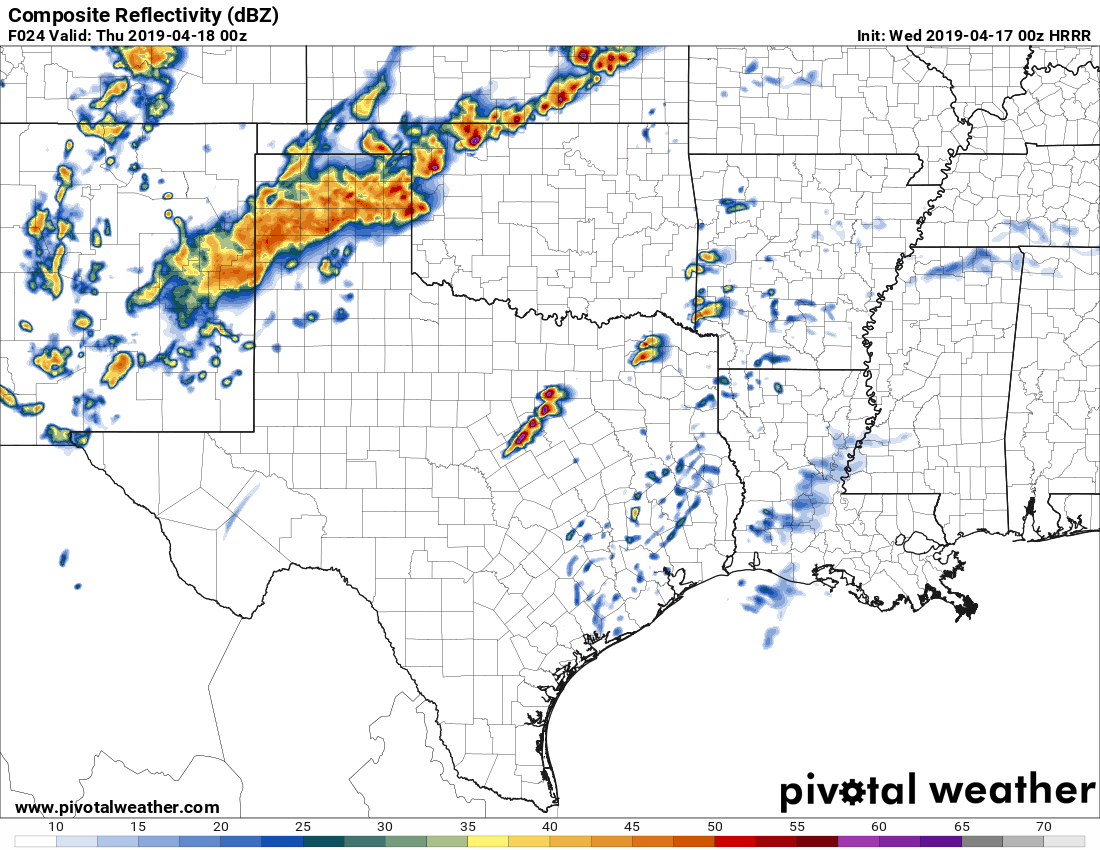
18z and 00z HRRR runs have discrete storms forming up near DFW at around 6-7pm or so:
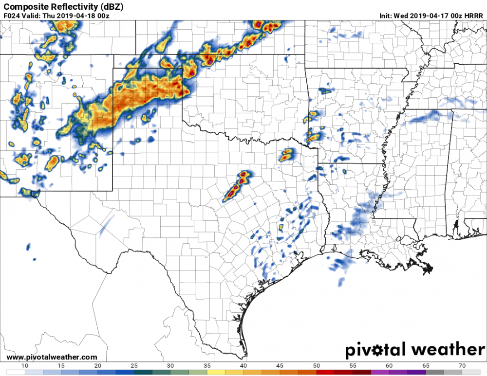
NAM and NAM3K (0z) have the storms moving through DFW about 3 hours later (and more linear on the 3K). Texas Tech's model also shows storms for DFW around the 7pm timeframe as well. Not total agreement among the CAMs shown on Pivotal Weather (including the HRW models) though; that said, I'm getting a bit concerned about the possibility of another damaging hailstorm in/near DFW if one of the models showing discrete storms does verify. I know there were some issues about VBV brought up with respect to the tornado threat though, but some of the models I've been looking at seem to lessen that a little bit (I believe). -
SPC sticking with an Enhanced Risk for Day 2. Northern edge of the 30% hatched zone shifted north to include OKC now as well. The entire 30% hatched zone encompasses the I-35 corridor from OKC to Austin.
Sig hatching is for hail per the maximum risk by hazard section of the outlook, but they also mention 10% TOR probabilities (non-hatched) as a maximum risk too.
-
2 hours ago, MattPetrulli said:
Thinking is some sups initiating along dryline in TX bringing hail and tornado threat for portions of DFW and areas surrounding.
I'm starting to get a bit concerned here in Fort Worth. The 18z NAM-based and GFS-based models show the storm threat a bit later though (either in the evening or early overnight hours), so maybe if those verify that could temper things a bit.
-
The NAM (today's 18z run) is suggesting some potential for tornadic supercells near and east of DFW, albeit with some VBV issues, though like StormChaser4Life said, it's long-range NAM so take it with a grain of salt. GFS-based models show less EHI across the North Texas area, and would suggest more of a threat in East Texas.
-
 1
1
-
-
TOR probabilities dropped back to 5% in SE OH.
-
And it looks like another batch of precipitation is trying to get going east of Cincinnati (but west of that band extending across KY into central OH), in the area near Mt Orab.
-
4 minutes ago, janetjanet998 said:
ATIONAL WEATHER SERVICE WILMINGTON OH
310 PM EDT SUN APR 14 2019
THE NATIONAL WEATHER SERVICE IN WILMINGTON HAS ISSUED A
* TORNADO WARNING FOR...
CENTRAL CHAMPAIGN COUNTY IN WEST CENTRAL OHIO...
NORTHWESTERN CLARK COUNTY IN WEST CENTRAL OHIO...
* UNTIL 345 PM EDT.
* AT 309 PM EDT, A SEVERE THUNDERSTORM CAPABLE OF PRODUCING A TORNADO
WAS LOCATED NEAR NEW CARLISLE, MOVING NORTHEAST AT 40 MPH.
HAZARD...TORNADO.Looks like that storm has also left behind a gust front from Springfield down towards Xenia.
-
Columbus is going to have to watch that area of storms moving in from the south, especially for the eastern half of the metro area. I believe that was the line that the earlier models really wanted to blow up into something significant. The HRRR has kind of backed down a bit though, but it is also not handling the storms near Dayton very well either.
-
1 minute ago, geddyweather said:
Watching the leading storm near Dayton trying to wrap up. Wondering if it can pull it off or not.
I thought for some reason it looked like that storm near Dayton was trying to develop a hook. I have a friend who is from New Carlisle so I'm definitely watching this.
-
Definitely eying those storms near Cincinnati for sure. Seems to be a pretty good environment there per SPC mesoanalysis.
-
Looks like an area of convection might be trying to go up west of Cincinnati, near Versailles, IN. Looks fairly insignificant even relative to the storms SW of Bloomington, IN for the moment, though.
EDIT: Meanwhile, based on this weather station at OSU, temperatures in Columbus are rising fast. Mid-60s are already present at the time of this edit. -
10 minutes ago, janetjanet998 said:
TOR probs increased
Not surprised at all. I had thought the area between Columbus and Pittsburgh was going to be the primary focus for tornadic development, but I'm wondering a bit about areas to the west of that 10% outline as well. The train of thought so far (and supported by the models, esp. HRRR) seems to be that storms will develop out ahead of those storms currently in south-central Indiana at the moment, which look like they have started to strengthen (though still sub-severe) based on the radar returns.
-
35 minutes ago, NTXYankee said:
Sun is making its way out in Columbus now.
Those temperatures seem to be rising like a rocket ship... upper 60s to near 70 around Cincinnati now, with mid-to-upper 50s in Columbus based on Wundermap data. I'm eagerly awaiting the 1630z SPC outlook.
The storms west of Louisville seem to be behaving themselves right now, but with temperatures in the lower-to-mid-70s (and dews in the upper 50s to lower 60s) out ahead of them, I don't know how much longer that will be the case. If those dews can get any higher, I bet it's only a matter of time before they strengthen. -
28 minutes ago, NTXYankee said:
ILN doing a nice job in their Twitter feed keeping people updated, posted recently that the atmosphere is becoming rapidly unstable with the clearing going on and folks need to pay attention.
That area with the clearing near and east of Cincinnati has rapidly warmed into the mid-60s, per Wundermap. Though I'm not sure of the reliability of the observations there, some personal weather stations are showing dewpoints in the lower 60s.
April 29-May 1 Severe Weather
in Central/Western States
Posted
I'm starting to wonder if storms could form earlier in the day (about 5-6 hours from now) over north-central Texas given the recent HRRR runs showing discrete activity around that time. RAP is depicting the same thing pretty much.
EDIT: interestingly enough SPC just downgraded most of DFW to a marginal risk.