

Sydney Claridge
-
Posts
532 -
Joined
-
Last visited
Content Type
Profiles
Blogs
Forums
American Weather
Media Demo
Store
Gallery
Posts posted by Sydney Claridge
-
-
Another weaker area of rotation seems to be either over or just north of Washington, IL as well, associated with the tornado-warned storm that went through Peoria.
-
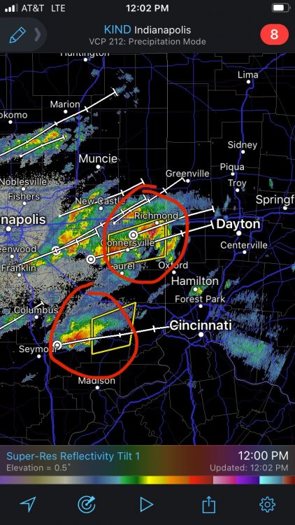
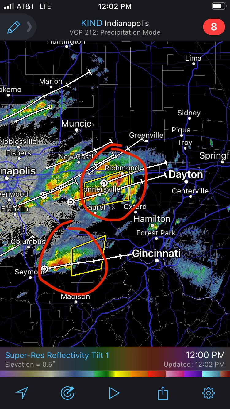
Time to start watching these severe-warned storms in SE Indiana. They are tracking towards Dayton and Cincinnati, will be potential for hail if they hold together.
-
That convection over western MO seems to be modeled (according to the 11z HRRR and the RAP shown on the SPC Mesoanalysis site) to make it to the Quad Cities in about 4 hours or so. The setup is not looking as potent as it did yesterday, but there may be some time to destabilize after this line passes.
-
10z HRRR still has high EHI and STP values around the IA/IL/MO border region, and now brings those values further east into NW IL, although I am not sure if this is the start of a trend. We'll see what happens with the "crapvection" and precipitation shield in NE OK and SE KS as it moves northeast, but I do not want to rule out a localized tornado outbreak just yet, though that MDT risk should be trimmed back away from the Chicago metro area. The warm front from central Illinois into southwest Pennsylvania may also need to be watched closely as well, and I would not be surprised to see a higher risk category added along that boundary.
EDIT: I definitely spoke too soon earlier about that convection in OK weakening, although that severe-warned storm near Tulsa appears to be weakening as it does not look as well organized as it was earlier. EDIT 2: severe t-storm warning dropped, and now that line is developing down into central Texas. Looks like I may get some thunder soon. -
Some of those storms in OK may be trying to drop in intensity, especially north of OKC. I’m starting to see more yellows and a little less of reds and oranges on the radar (with radar returns around the stronger cores), although I am not sure if this is the start of a weakening trend. Perhaps some cloud/anvil debris is interfering with storms to the north of OKC?
-
6 minutes ago, janetjanet998 said:
The current OK stuff is the crapvection..the northern edge precip/clouds will be over IL by midday
Makes sense. I guess on the bright side a lot of worries about strong, long-tracked tornadoes could be alleviated, provided that this convection holds together. That said, it looks like the risk for severe thunderstorms might have increased along the I-70 corridor in Indiana, Ohio, and SW Pennsylvania. Cities like Indianapolis, Dayton, Columbus, and Pittsburgh could now be in the line of fire, and what's crazy is that 08z HRRR outputs PDS soundings at 18z near Pittsburgh. Several HRRR and RAP runs, for about the last day or so (though on-and-off to an extent as I recall), have shown an area of increased parameters in E OH and SW PA.
-
One of those storms in Oklahoma just went severe, and it is moving extremely fast to the northeast. Although this should go in the Central/Western States subforum, this is the main thread for this severe weather event, so I’ll go ahead and post this warning here.
QuoteBULLETIN - IMMEDIATE BROADCAST REQUESTED
Severe Thunderstorm Warning
National Weather Service Norman OK
342 AM CDT Sat Mar 28 2020The National Weather Service in Norman has issued a
* Severe Thunderstorm Warning for...
North central Comanche County in southwestern Oklahoma...
Northwestern Grady County in central Oklahoma...
Southern Caddo County in southwestern Oklahoma...
East central Kiowa County in southwestern Oklahoma...* Until 415 AM CDT.
* At 342 AM CDT, a severe thunderstorm was located 6 miles northwest
of Boone, moving northeast at 85 mph.HAZARD...Ping pong ball size hail and 60 mph wind gusts.
SOURCE...Radar indicated.
IMPACT...People and animals outdoors will be injured. Expect hail
damage to roofs, siding, windows, and vehicles. Expect
wind damage to roofs, siding, and trees.* Locations impacted include...
Anadarko, Carnegie, Apache, Fort Cobb, Verden, Amber, Gracemont,
Pocasset, Meers, Boone, Albert, Lake Chickasha, Fort Cobb
Reservoir, Stecker and northeastern Wichita Mountains Wildlife
Refuge.PRECAUTIONARY/PREPAREDNESS ACTIONS...
For your protection move to an interior room on the lowest floor of a
building.EDIT: the activity in central IL (from Springfield to Champaign) looks like it may be trying to fall apart. Unless more convection tries to form later on (as twistingtornado suggests if the 06z HRRR run verifies), the warm front may not have too much of a problem moving northwards towards the I-80 corridor. However, 08z HRRR is showing storms in northeastern MO at around 15z, and the HRRR model says that this would be the northeastern continuation of the activity currently approaching Oklahoma City.
-
17 minutes ago, twistingtornado said:
06z HRRR run has no discrete cells forming in Northern Illinois due to earlier crapvection. Compare 00z run to 06z run valid at 18z. The cap doesn't hold as a shortwave trough ejects northeast over Iowa in the late morning. Threat for northern Illinois would be nil. A messy storm mode ensues in west and central Illinois, but looks like there could be a few discrete cells that take advantage of their environment in that region. This is trending toward an enhanced risk instead of a high risk.
What is interesting right now, however, is that much of the “crapvection” is well north of the surface warm front, aside from what is present in central IL north of I-70, and an area of convection trying to form a line way back in western Oklahoma and northern Texas. The entire state of Missouri seems to be free of convection for the moment, so I am starting to wonder about the impact that TX/OK activity might have if it holds together.
-
06z HRRR may be attempting to re-orient the threat area away from northern IL and is firing up storms along a frontal boundary from central IL to SW PA.
-
13 minutes ago, Indystorm said:
HRRR just won't back off. Now develops tornadic cells ahead of the main line including one nw of LAF area.
If those HRRR runs verify I would not be surprised to see (potentially tornadic?) supercells as far east as Pittsburgh. This (05z) HRRR run puts a cell pretty close to Columbus, OH (at 20z) as well, not to mention RAP also shows precipitation along that warm frontal boundary in Indiana/Ohio/SW Pennsylvania.
-
1 minute ago, yoda said:
30% hatched hail is JUST south of Chicago metro
Almost all of the Chicago metro is in the 30% hatched hail risk. And a 10% hatched tornado risk all the way to the lake, with the 15% hatched tornado risk getting into the western parts of the metro.
-
SPC MD says the storms in central MO are elevated, but I am starting to wonder about that cell approaching Jefferson City. SPC Mesoanalysis shows 1000+ J/kg SBCAPE, 0-3km EHI between 2 and 3, and little CIN in that area.
This looks to be a major hail producer nevertheless. -
SPC Mesoanalysis is showing an area of upper-60s dewpoints just east of St. Louis right now. If these high dewpoints are already in place, I do not want to discount the possibility of dewpoints around 70 in Illinois tomorrow.
-
26 minutes ago, joshwx2003 said:
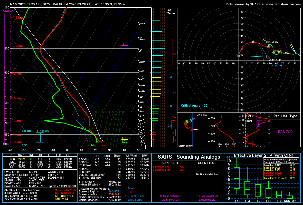
Holy cow STP values are maxed out with the 12z HRRR 33 hours out
I believe those maxed-out STP values are from convectively-contaminated model output, which is not reflective of the background environment. Nevertheless the 12z HRRR still shows high STP values in the background environment.
EDIT: never mind, given the linked post from Vortex Crew below. I was looking at the 12z HRRR output on Pivotal Weather. -
06z HRRR has a major storm complex moving through Illinois, Indiana, and Ohio (and even into SW PA/N WV) during the morning hours on Saturday (overnight/early morning in IL), before the main action would get started in Illinois. While generally elevated, some of this complex is modeled to get fairly close to some SBCAPE. If this complex verifies we might see outflow boundaries come into play later in the day, but my experience with HRRR models is that they are quite bullish.
-
1 minute ago, Hoosier said:
It is a pretty good setup, but 11/17/13 had a larger area of better tornado potential than this does. I am not sure I agree with the comparison even if we limit it to Illinois, but you can make a better case with that vs a larger regional comparison.
I agree with that. April 9, 2015 may be the better comparison here, especially with the similarities in expected areal coverage for significant tornadoes. 11/17/13 was generally further east with the favorable area for tornadoes extending across Indiana and even into Ohio (though few tornadoes occurred in OH, several touched down in northern IN).
-
With that drastic risk increase, I am getting more concerned that a scenario comparable to the November 17, 2013 tornado outbreak could be within the realm of possibilities, at least for Illinois.
-
11 minutes ago, Bob's Burgers said:
WRF firing up quite a few cells as well
0z WRF-ARW also fires up cells along the warm front in central Ohio as well, including a decent looking cell in the vicinity of the Columbus area around 20z Saturday. While I do expect the main tornado threat to be in Illinois, if this verifies there might be severe thunderstorms (and perhaps tornadoes) further east as well, but the WRF-ARW is definitely an outlier here by showing storms along the warm front.
I'm not sure what to think about comparisons with April 9, 2015 yet. Some of the models showing broken cells in Illinois and a possible precipitation shield along the lower MS/OH valleys (eg. NAM) remind me of the radar returns on November 17, 2013, but that was a major tornado outbreak (though I think that precipitation shield, as it moved northeast, helped to reduce the severity of storms in the eastern half of the high-risk area in IN/W OH). I do not wish to compare with 11/17/13 though since this does not seem to be that type of event.
There is a question of model accuracy though, given the reduction in commercial flights to take weather data that can be fed into the computer models. -
Laredo got well into the triple-digits today for their high temperature today (3/26). And I believe my location (Fort Worth, TX) got to 90 yesterday, although temperatures were cooler today. What is interesting is that I am seeing what could be convection trying to go up over north-central Texas, both on satellite imagery and outside my window.
I know there is a cool down coming, but it seems that summer wants to try and appear early. If heat like this tries to show up again in April (we will likely see this again by the end of May), I am wondering about the effects on the severe storm season; for Texas that would probably mean more capping and a stronger EML, but elsewhere (further north and further east) that might mean more severe storms. For instance, I know the EML is modeled to move north-east over Missouri and Illinois for their severe storm event on Saturday. -
This same 18z NAM run also ramps up tornado parameters along the warm front in eastern Ohio at the same time as well, as per this forecast sounding. The NAM does not initiate precipitation in this area though, so it seems the threat there would be much more conditional if this run verifies. Forecast parameters are lower in the area between E OH and IL.
Lapse rates on the 18z NAM run are also pretty high, with Plains-like 7.5-8.5 values from Illinois over into Ohio.
-
I am now in the precipitation shield here in west Fort Worth, hearing occasional rumbles of thunder. Hopefully this will put a damper on any severe storm activity here in DFW moving forward, although the 10z HRRR does show a strong supercell moving into the southern metro around 2 hours from the time of this post (I doubt that will happen though; EDIT: 11z HRRR does not show storms nearly as strong). There might be more storms around in the afternoon, but that is nowhere near guaranteed for the DFW area (maybe areas to the east are more likely to see more severe storms).
Some of the following pertains more to the Lakes/Ohio Valley subforum, but I am going to post it here considering this has been the main thread for this event.
I have noticed several HRRR and RAP runs might keep the warm front in Iowa a bit further south than anticipated. While southern IA was not the highest-risk area for tornadoes on the initial Day 1 outlook (SE MO to SW IN was), I am wondering whether the risk there might be a bit overstated. On the other hand, there may be the possibility for severe storm activity further east, as HRRR and RAP runs suggest an area of high helicity will move over IN and OH. If these HRRR and RAP runs are correct, this area of high helicity may correspond with some surface instability and precipitation in the area around 0z this evening, although the 10z HRRR backs off and does not get surface instability up into central Ohio (while other HRRR/RAP model runs do bring this instability at least as far northeast as Columbus). I would not be surprised to see tornado and severe storm probabilities increased further to the east, in association with what appears to be a warm frontal zone, if these models are on to something.EDIT: it seems SPC thinks that SW Iowa and SE Nebraska could be a hotspot for later severe thunderstorm activity. A 10% tornado contour was added there as well.
-
Rotation appears to be getting weaker and more disorganized around Jacksboro. Hopefully this storm is finally starting to wind down, and if so, that would be a relief for places like Chico and Alvord that were hit earlier. But you never know if it might restrengthen.
EDIT: tornado warning has been dropped. I believe this storm had a tornado warning continuously since prior to moving over/near Sterling City, NW of San Angelo. -
Graham is once again under a tornado warning, albeit at the northeastern-most edge of the warning polygon. It seems they had a tornado in the area with the previous round of storms, and this new warning only adds insult to injury.
I'm worried that this supercell might try to take a similar path to the earlier storm that moved over Chico and Alvord. -
The storm north of Breckenridge is now beginning to enter areas previously impacted by tornado-warned supercells several hours ago. Areas like Graham, Bryson, and Jacksboro could be in the path once again if this storm stays on its present path.

March 26-28 Severe Threat
in Lakes/Ohio Valley
Posted
Very strong rotation evident as this storm moves towards Rockford. Hopefully the cool surface temperatures temper things a little bit, but I wouldn’t bet on it.
EDIT: rotation seems to have weakened in the last frame or so.