

Sydney Claridge
-
Posts
507 -
Joined
-
Last visited
Content Type
Profiles
Blogs
Forums
American Weather
Media Demo
Store
Gallery
Posts posted by Sydney Claridge
-
-
Tornado warning for cell over the Augusta area, about to move into SC. I was thinking that this cell needed to be watched with it being almost out by itself.
-
Going to need to watch the open warm-sector convection trying to go up in southern Alabama and southeastern Mississippi. If a supercell can get going, there is a favorable environment for tornadoes there.
Fortunately everything just seems like “popcorn” convection on the radar right now, though there are some sickle shapes on the radar east of Montgomery, near Mobile, and north of Biloxi. Areas between Mobile and Montgomery have the best instability and EHI to work with.
-
Had a dusting of snow up near Texas Motor Speedway earlier today.
-
GFS seems quite the outlier right now, depicting a major snowstorm over the north Texas area (especially just west of DFW) on Wednesday. Most other models (NAM, Euro, etc.) are further north.
-
Looks like activity is now starting to ramp up west of Shreveport. Many storms in that area seem to be getting that "look" (hooks) on the radar.
-
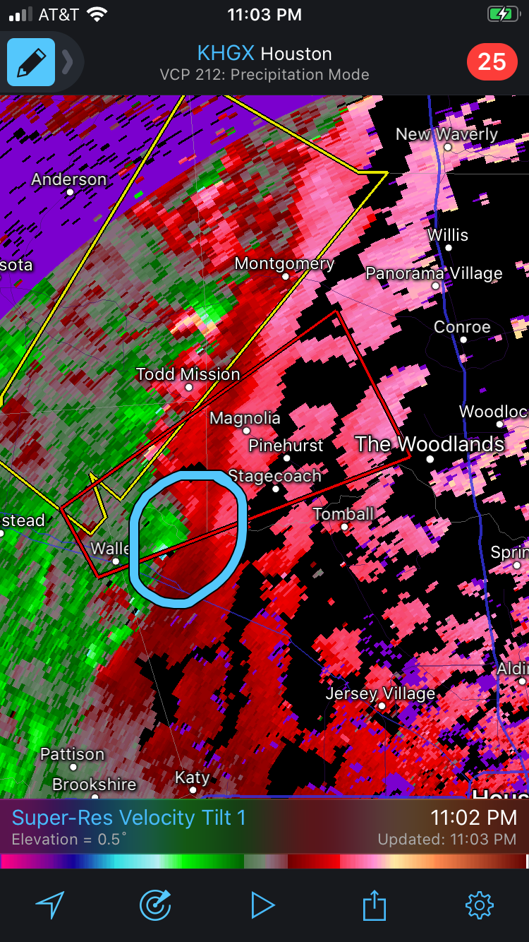
New tornado warning northwest of the Houston metro area. Portions of the northernmost Houston metro area (The Woodlands and Conroe) will need to watch out if this can hold together.

-
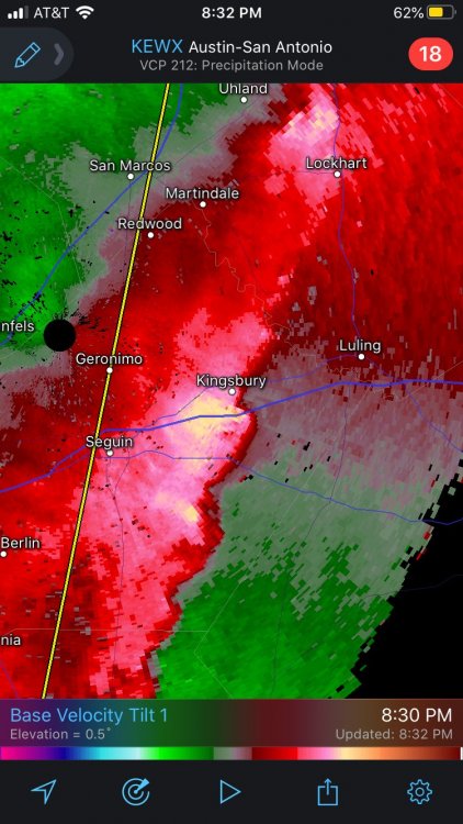
And there’s now a tornado warning on that Kingsbury storm. (there also had been a TW when it passed over Seguin)
-
Looks like Kingsbury, TX (east of Seguin) is getting hammered by straight-line winds right about now.
-
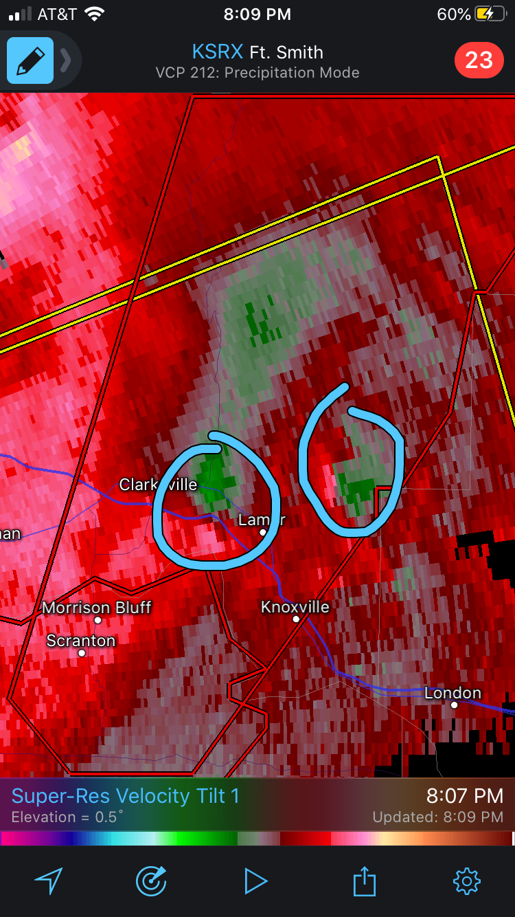
Seems like there are two areas of rotation with the Clarksville cell:

-
2 minutes ago, Chargers09 said:
Looks like the southern portion is racing ahead so that part should. I'm in north central SA, watching closely.
There seems to be a weak area of rotation East of Castroville and moving towards US 90 and West Loop 1604, nothing impressive though. Will need to watch how it interacts with the outflow though.
-
6 minutes ago, Chargers09 said:
Not sure if it picked up on an extra boundary (or outflow) but yeah, seeing a lot of small hooks and kinks in the line now.
Yeah, there seems to be an outflow boundary in place. If these hooks can get out ahead of the outflow (of which I’ve drawn below), watch out:
-
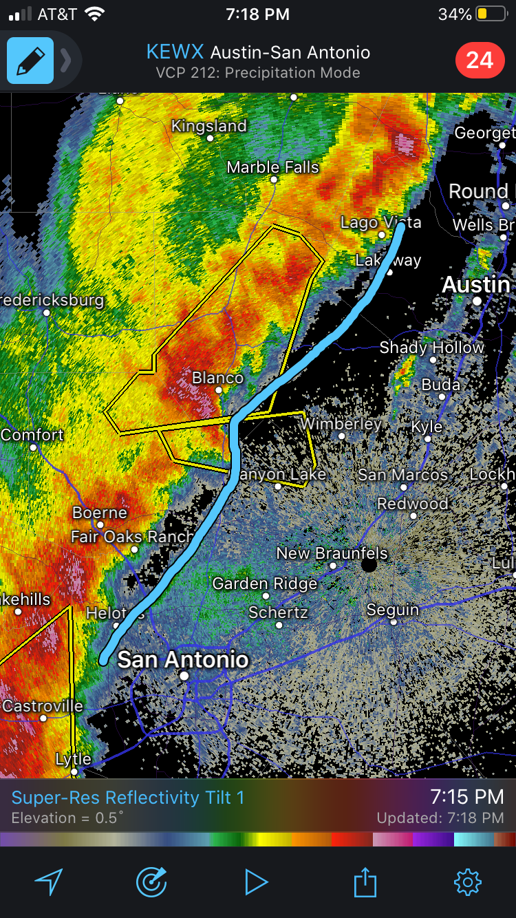
1 minute ago, Chargers09 said:
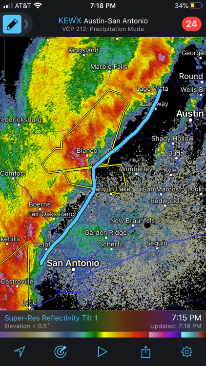
Nasty hook/notch on the leading edge of the tornado warned cell just north of San Antonio.
I was about to mention the storms moving towards the San Antonio and Austin metro areas. I’m starting to get a little concerned about these storms, especially if they start showing hooks (and velocity couplets) on radar as you mentioned.
-
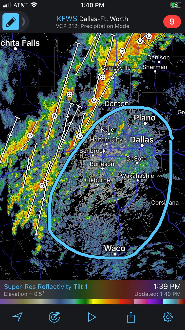
For the DFW area I would be more concerned if I saw stronger radar returns trying to form in the circled area below.
Also any right-movers developing out of that area of heavy precipitation to the west could be a risk for the western Metroplex.

-
5 minutes ago, Drz1111 said:
Some of the more active updrafts seem to be "drilling down" through the inversion. IIRC there's a case study of that from an upper Midwest outbreak several years ago where conditions were otherwise quite favorable
I remember one time several years ago there was a situation where storms to the west of DFW acted to remove a capping inversion over DFW due to rain-cooled air falling out of the storm anvils, and then storms rapidly went up over the Metroplex. So I could completely see how rain-cooled air aloft could remove an inversion.
-
Tornado watch now out for north-central Texas.
-
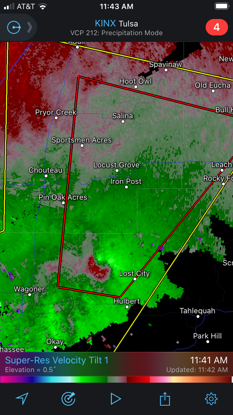
Severe-warned storm coming into Muskogee seems to be developing a fairly-pronounced hook echo with a velocity couplet.
EDIT: and now it is tornado-warned. -
Meanwhile radar returns are increasing over and near the DFW Metroplex, primarily Denton County at this time. These particular areas of development seem primed to become more of a severe thunderstorm threat as they move further north.
In terms of a DFW-area severe storm threat, I'm continuing to watch for potential development south or southwest of the DFW area, though, and (fortunately) there is nothing in that area yet.
The rotation has also weakened on that NE OK storm too. -
Some strong low-level rotation is ongoing with a storm in NE OK right now.

-
And it has started. Two tornado warnings now up in central Oklahoma, one near Prague and one near Atwood.
-
With all of that warm, humid air out ahead of this storm system, the lack of instability forecasted seems unfortunate. I don't think it would take much CAPE at all to get severe-criteria thunderstorms from a storm system like this. Though I wouldn't be surprised to see a line of showers with severe wind gusts anywhere from SE IL to eastern OH with several models showing a potent low-level jet.
(there wasn't a severe thread in this sub, as warm-sector severe isn't expected, so I thought it was best to put that here since it does relate to this storm)-
 3
3
-
-
1 hour ago, cheese007 said:
Not looking forward to my drive from Fort Worth to Dallas around 2 - 3 PM tomorrow
I'll be driving from the west side of Fort Worth to northern Tarrant County around that same time (just before that) as well. Today's 12z NAM3k and HRRR runs both suggest storm initiation around 2pm or so for DFW. If the 12z NAM3k verifies things wouldn't be too bad in Tarrant County, but that 12z HRRR run spells trouble with semi-discrete activity.
-
1 hour ago, cheese007 said:
Coldest highs for DFW in most 10 day forecasts are in the upper 50s at the coldest. Might hit the 70s later this week. Makes me dread the summer
Maybe an early start to the spring severe season is in order? Not going to comment on summer at this time.
GFS gives some threat across the SPC-delineated regions for Friday and Saturday though the Euro runs look more amped (bringing a fairly-humid warm sector as far north as the Ohio Valley next weekend); if those Euro runs verify then a stronger storm system would track from central Texas to the Midwest-Great Lakes region.
EDIT: The only cold I see for DFW is way out in GFS fantasy land. I guess we know how that tends to go. -
I'll guess 1250 total tornadoes, first high risk April 1st.
-
I know we are only in a marginal risk zone, but the storm parameters over the DFW area look somewhat interesting right now. Temperatures in the lower 70s (in places) with upper 60s dew points, in conjunction with some high helicity values (ESRH in the 300-500+ m2/s2 range), could produce some potentially severe storms if we can get storm initiation, though veer-back-veer seems to be an issue based on the change in wind directions between the 700mb and 500mb levels (based on the available SPC mesoanalysis data at the time of this post).

Texas/New Mexico/Louisiana/Mexico Obs And Discussion Thread Part 8
in Central/Western States
Posted
Storm initiation looks to have started just east of Wichita Falls. Looks to be on the front itself.