

Sydney Claridge
-
Posts
532 -
Joined
-
Last visited
Content Type
Profiles
Blogs
Forums
American Weather
Media Demo
Store
Gallery
Posts posted by Sydney Claridge
-
-
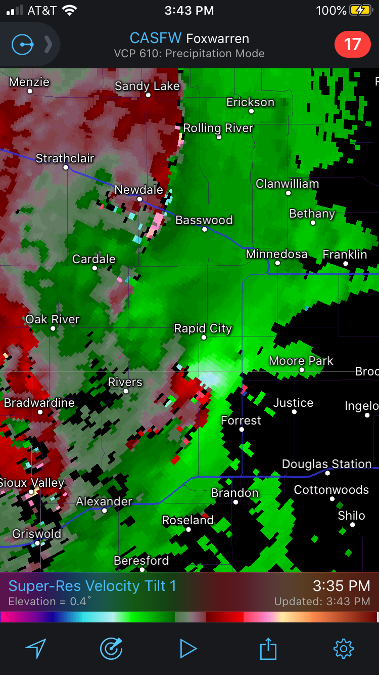
I'm starting to wonder about those storms west of the Twin Cities. Not seeing anything too strong with rotation at this time, but they are all isolated storms in a favorable environment. The severe-warned storm south of Buffalo Lake may be one to watch. There also appears to be a couple of couplets near West Union (along I-94), but these look to be on the frontal boundary itself.
-
1 hour ago, yoda said:
First moderate risk day in quite a long time... since mid June? Wind driven... and it's a small mod risk
ETA: never seen a hatched wind on a 15 percent before... on the new Day 2
I've noticed that SPC has included hatching on 15% wind risks, starting earlier this year, when there is potential for a major damaging wind event but there is a degree of uncertainty as to whether said threat will actually materialize (such as capping, etc.).
-
 1
1
-
-
We have a tornado watch in North Dakota for today. Meanwhile, across the Canadian border in Manitoba it looks like there is a storm with significant rotation:

-
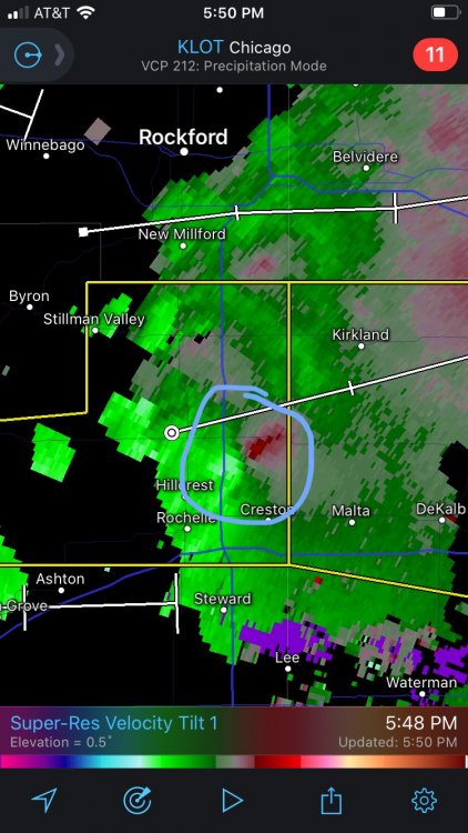
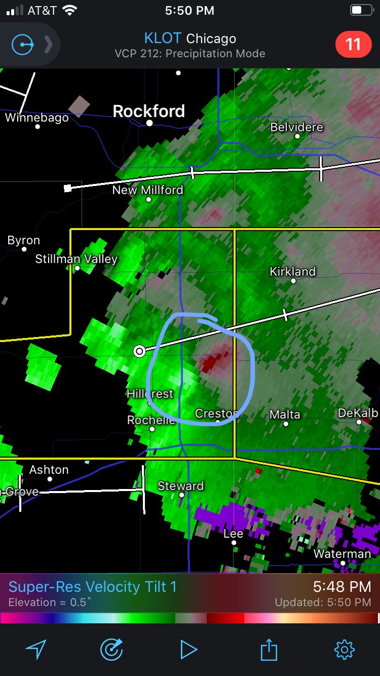
Might that be rotation trying to form northeast of Rochelle?
-
5 minutes ago, HillsdaleMIWeather said:
Surprise Ohio TOR
The National Weather Service in Cleveland has issued a

* Tornado Warning for...
  Southeastern Knox County in north central Ohio...

* Until 645 PM EDT.

* At 611 PM EDT, a severe thunderstorm capable of producing a tornado
  was located near Mount Vernon, moving southeast at 25 mph.

  HAZARD...Tornado and quarter size hail.

  SOURCE...Radar indicated rotation.

  IMPACT...Flying debris will be dangerous to those caught without
           shelter. Mobile homes will be damaged or destroyed.
           Damage to roofs, windows, and vehicles will occur.  Tree
           damage is likely.
There is also a severe-warned storm behind this one (Marion, OH area). Would not be surprised if that one could clip the northeastern portions of the Columbus area only if that storm takes a right-turn.
Ingredients for tornadoes are much better in northern Illinois per SPC mesoanalysis. Watch those storms west of Rochelle and Rockford as they move east, could be a concern as they approach Chicagoland. -
0-3km EHI is as high as 10 along the OR/WA border. I have never seen values that high in the Pacific Northwest before, but keep in mind that LCL heights are very high. Storm south of (and moving towards) Bend, OR has lower LCL heights.
-
5 minutes ago, Arishtat said:
Just curious, you mean the one north, or the one south of town? Still trying to learn to read radar.
Even though the one to the south is the tornado producer, that storm to the north of Streator (near Ottawa) still bears watching as it is moving straight for the Chicago metro area.
-
Aside from the risk for hail, tornadoes, and wind, I am getting very concerned about flooding potential near and west of Bowie, TX. These storms have stalled over this area for quite some time, with heavy precipitation, and they may only now be starting to increase their forward motion. There are also other storms behind this complex as well.
The big question is whether this complex will take a right turn and impact the northern areas of the Metroplex. -
I wonder if that is an MCV associated with that activity near Bowie, TX? Storm motions seem to be rotating around a point near Bowie.
-
Storm over Wichita Falls looks to be developing rotation. It looks as if that storm has caught up to the outflow boundary ahead of it and is latching onto that OFB.
-
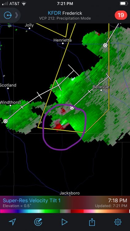
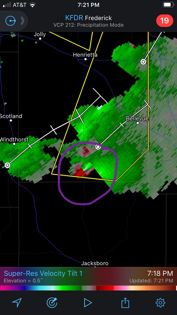
I'm starting to wonder if SPC overestimated the effects of the outflow boundary with respect to their re-positioning of the ENH risk earlier. The significant hail is currently materializing north of the ENH risk and the hatching, but that storm SW of Bellevue, TX still bears watching, especially if it becomes a right-mover. That storm has just taken on supercellular characteristics (including a hook), so it may take a right turn pretty soon.
EDIT: couplet SW of Bellevue:
-
Tornado warning also issued for that storm just northwest of Wichita Falls. Radar indicated at this time.
EDIT: confirmed tornado west of Burkburnett according to livestream from Channel 6 in Wichita Falls. -
Looks like there is a major hail storm ongoing northwest of Wichita Falls now, it is warned for up to 3-inch hail. There may be some additional attempts at convective initation in the Graham/Jacksboro area per radar and satellite imagery; some of the ingredients there seem better for severe weather (supercell composite, SigTor, EHI, etc.), compared with southern OK, although that Red River storm is in a perfect position to produce large hail.
-
Attempts at convective initiation around Graham and Jacksboro seem to be struggling at this moment. Some light radar returns are present there, although nothing significant has formed yet.
-
Looks like some attempts at convective initiation may be occurring near Jacksboro, TX.
-
Enhanced risk is now centered over north Texas, including the Metroplex, and has been trimmed away from southern OK. OFB is now over the Metroplex, albeit with strong heating on the immediate north side of the boundary based on observations and SPC outlook.
-
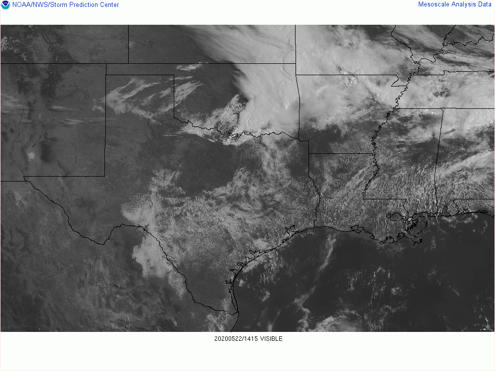
The question will be how much further south the OFB gets before storms initiate (which will be a while). Though not the most current, satellite imagery clearly shows the OFB location just south of the Red River. SPC thinks that the boundary will eventually stall; needless to say I'm going to get a bit concerned about severe storms particularly if the OFB stalls out near the Metroplex, since the OFB may very well be the focal point for afternoon severe storms.
-
2 hours ago, WhiteoutWX said:
With the MCS already nearing the edge of the enhanced me thinks they’ll be trimming that a bit.
Yep, the 10% with SigTor hatching was just removed and the ENH was shifted southwards somewhat. On the flip side, the hatching for significant hail now covers much of the Metroplex (30% hatched), with a 5% tornado probability on top of that.
-
That storm is moving straight for the Columbus metro area. Fortunately the ingredients today are not the most favorable for anything more than brief tornadoes, but it is always something to watch when a major metropolitan area is downstream from a potentially tornadic thunderstorm.
-
1
-
-
13 minutes ago, pbrussell said:
Iowa’s blowing up
Have definitely seen what seem to be some supercell structures on radar there, but overall the storm mode in Iowa seems messy right now.
Obviously today is not a slam-dunk severe weather day, being only a slight risk, but if anything the most intense storm near New Virginia, IA looks to be a possible HP supercell given its radar signature.
-
Just now, cheese007 said:
Supercell near Fort Worth still trucking. Dropping 2 inch hail
Southwest Tarrant County looks to get hammered should this storm continue to hold together.
-
15 minutes ago, TexMexWx said:
Welp. I was thinking the storm would go south through Denton and Tarrant counties but it's taken an interesting turn to the east and looks like it'll hit here in southern Collin County... warned for 65 mph winds and ping pong ball sized hail.
Those storms are definitely outflow-dominant now. The outflow boundary has surged well ahead of the storms, and is currently over central Dallas County and southern Tarrant County (and is just north of the KFWS radar site). If these storms had maintained unimpeded inflow at or near the surface we would probably be having a major hailstorm over DFW right now, but fortunately that outflow surged out ahead of the storms.
-
Interestingly enough there might be some outflow out ahead of this storm, from west of Thackerville over to Muenster and Bowie (which is evident on the KFWS radar). Might be a sign of a possible weakening trend, but this does not appear ahead of the lead storm over Thackerville.
-
8 minutes ago, cheese007 said:
Do wonder if that storm could make it intact to the metroplex
Hopefully the hail potential winds down somewhat before then, but you can never count on that (the cap is one finicky beast at times). Collapsing storms can also produce damaging wind gusts on occasion, so even if the hail threat diminishes, there is that risk (although this storm is already capable of damaging wind as it is). I would not be surprised to see a local extension of the severe thunderstorm watch into Tarrant and Dallas counties.

Severe Weather Threat 8-14-20
in Central/Western States
Posted
That line up by Saint Cloud just lit up with 4 tornado warnings. Looks like another couplet is forming on a tornado-Warner supercell (ahead of the line) just north of Brownton, MN as well. The Brownton storm might try to make a run at the Twin Cities metro if it holds together.