Sydney Claridge
-
Posts
500 -
Joined
-
Last visited
Content Type
Profiles
Blogs
Forums
American Weather
Media Demo
Store
Gallery
Everything posted by Sydney Claridge
-

March 26-28 Severe Threat
Sydney Claridge replied to Tim from Springfield (IL)'s topic in Lakes/Ohio Valley
One of those storms in Oklahoma just went severe, and it is moving extremely fast to the northeast. Although this should go in the Central/Western States subforum, this is the main thread for this severe weather event, so I’ll go ahead and post this warning here. EDIT: the activity in central IL (from Springfield to Champaign) looks like it may be trying to fall apart. Unless more convection tries to form later on (as twistingtornado suggests if the 06z HRRR run verifies), the warm front may not have too much of a problem moving northwards towards the I-80 corridor. However, 08z HRRR is showing storms in northeastern MO at around 15z, and the HRRR model says that this would be the northeastern continuation of the activity currently approaching Oklahoma City. -
March 26-28 Severe Threat
Sydney Claridge replied to Tim from Springfield (IL)'s topic in Lakes/Ohio Valley
What is interesting right now, however, is that much of the “crapvection” is well north of the surface warm front, aside from what is present in central IL north of I-70, and an area of convection trying to form a line way back in western Oklahoma and northern Texas. The entire state of Missouri seems to be free of convection for the moment, so I am starting to wonder about the impact that TX/OK activity might have if it holds together. -
March 26-28 Severe Threat
Sydney Claridge replied to Tim from Springfield (IL)'s topic in Lakes/Ohio Valley
06z HRRR may be attempting to re-orient the threat area away from northern IL and is firing up storms along a frontal boundary from central IL to SW PA.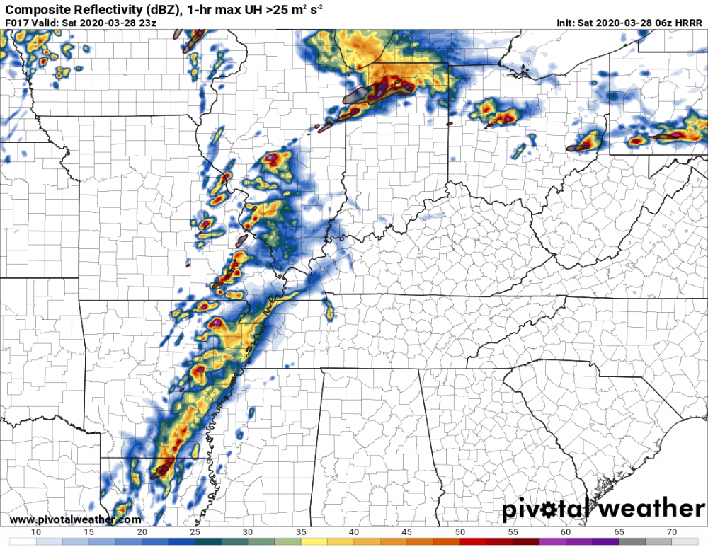
-
March 26-28 Severe Threat
Sydney Claridge replied to Tim from Springfield (IL)'s topic in Lakes/Ohio Valley
If those HRRR runs verify I would not be surprised to see (potentially tornadic?) supercells as far east as Pittsburgh. This (05z) HRRR run puts a cell pretty close to Columbus, OH (at 20z) as well, not to mention RAP also shows precipitation along that warm frontal boundary in Indiana/Ohio/SW Pennsylvania. -
March 26-28 Severe Threat
Sydney Claridge replied to Tim from Springfield (IL)'s topic in Lakes/Ohio Valley
Almost all of the Chicago metro is in the 30% hatched hail risk. And a 10% hatched tornado risk all the way to the lake, with the 15% hatched tornado risk getting into the western parts of the metro. -
March 26-28 Severe Threat
Sydney Claridge replied to Tim from Springfield (IL)'s topic in Lakes/Ohio Valley
SPC MD says the storms in central MO are elevated, but I am starting to wonder about that cell approaching Jefferson City. SPC Mesoanalysis shows 1000+ J/kg SBCAPE, 0-3km EHI between 2 and 3, and little CIN in that area. This looks to be a major hail producer nevertheless. -
March 26-28 Severe Threat
Sydney Claridge replied to Tim from Springfield (IL)'s topic in Lakes/Ohio Valley
SPC Mesoanalysis is showing an area of upper-60s dewpoints just east of St. Louis right now. If these high dewpoints are already in place, I do not want to discount the possibility of dewpoints around 70 in Illinois tomorrow. -
March 26-28 Severe Threat
Sydney Claridge replied to Tim from Springfield (IL)'s topic in Lakes/Ohio Valley
I believe those maxed-out STP values are from convectively-contaminated model output, which is not reflective of the background environment. Nevertheless the 12z HRRR still shows high STP values in the background environment. EDIT: never mind, given the linked post from Vortex Crew below. I was looking at the 12z HRRR output on Pivotal Weather. -
March 26-28 Severe Threat
Sydney Claridge replied to Tim from Springfield (IL)'s topic in Lakes/Ohio Valley
06z HRRR has a major storm complex moving through Illinois, Indiana, and Ohio (and even into SW PA/N WV) during the morning hours on Saturday (overnight/early morning in IL), before the main action would get started in Illinois. While generally elevated, some of this complex is modeled to get fairly close to some SBCAPE. If this complex verifies we might see outflow boundaries come into play later in the day, but my experience with HRRR models is that they are quite bullish. -
March 26-28 Severe Threat
Sydney Claridge replied to Tim from Springfield (IL)'s topic in Lakes/Ohio Valley
I agree with that. April 9, 2015 may be the better comparison here, especially with the similarities in expected areal coverage for significant tornadoes. 11/17/13 was generally further east with the favorable area for tornadoes extending across Indiana and even into Ohio (though few tornadoes occurred in OH, several touched down in northern IN). -
March 26-28 Severe Threat
Sydney Claridge replied to Tim from Springfield (IL)'s topic in Lakes/Ohio Valley
With that drastic risk increase, I am getting more concerned that a scenario comparable to the November 17, 2013 tornado outbreak could be within the realm of possibilities, at least for Illinois. -
March 26-28 Severe Threat
Sydney Claridge replied to Tim from Springfield (IL)'s topic in Lakes/Ohio Valley
0z WRF-ARW also fires up cells along the warm front in central Ohio as well, including a decent looking cell in the vicinity of the Columbus area around 20z Saturday. While I do expect the main tornado threat to be in Illinois, if this verifies there might be severe thunderstorms (and perhaps tornadoes) further east as well, but the WRF-ARW is definitely an outlier here by showing storms along the warm front. I'm not sure what to think about comparisons with April 9, 2015 yet. Some of the models showing broken cells in Illinois and a possible precipitation shield along the lower MS/OH valleys (eg. NAM) remind me of the radar returns on November 17, 2013, but that was a major tornado outbreak (though I think that precipitation shield, as it moved northeast, helped to reduce the severity of storms in the eastern half of the high-risk area in IN/W OH). I do not wish to compare with 11/17/13 though since this does not seem to be that type of event. There is a question of model accuracy though, given the reduction in commercial flights to take weather data that can be fed into the computer models. -
Laredo got well into the triple-digits today for their high temperature today (3/26). And I believe my location (Fort Worth, TX) got to 90 yesterday, although temperatures were cooler today. What is interesting is that I am seeing what could be convection trying to go up over north-central Texas, both on satellite imagery and outside my window. I know there is a cool down coming, but it seems that summer wants to try and appear early. If heat like this tries to show up again in April (we will likely see this again by the end of May), I am wondering about the effects on the severe storm season; for Texas that would probably mean more capping and a stronger EML, but elsewhere (further north and further east) that might mean more severe storms. For instance, I know the EML is modeled to move north-east over Missouri and Illinois for their severe storm event on Saturday.
-
2020 Short/Medium Range Severe Thread
Sydney Claridge replied to Hoosier's topic in Lakes/Ohio Valley
This same 18z NAM run also ramps up tornado parameters along the warm front in eastern Ohio at the same time as well, as per this forecast sounding. The NAM does not initiate precipitation in this area though, so it seems the threat there would be much more conditional if this run verifies. Forecast parameters are lower in the area between E OH and IL. Lapse rates on the 18z NAM run are also pretty high, with Plains-like 7.5-8.5 values from Illinois over into Ohio.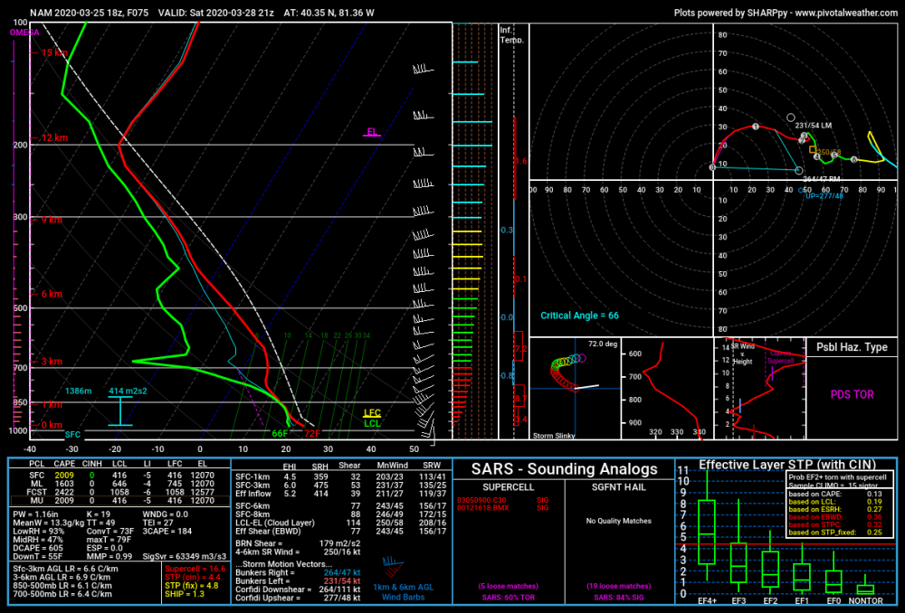
-
Severe Weather March 15-19
Sydney Claridge replied to Sydney Claridge's topic in Central/Western States
I am now in the precipitation shield here in west Fort Worth, hearing occasional rumbles of thunder. Hopefully this will put a damper on any severe storm activity here in DFW moving forward, although the 10z HRRR does show a strong supercell moving into the southern metro around 2 hours from the time of this post (I doubt that will happen though; EDIT: 11z HRRR does not show storms nearly as strong). There might be more storms around in the afternoon, but that is nowhere near guaranteed for the DFW area (maybe areas to the east are more likely to see more severe storms). Some of the following pertains more to the Lakes/Ohio Valley subforum, but I am going to post it here considering this has been the main thread for this event. I have noticed several HRRR and RAP runs might keep the warm front in Iowa a bit further south than anticipated. While southern IA was not the highest-risk area for tornadoes on the initial Day 1 outlook (SE MO to SW IN was), I am wondering whether the risk there might be a bit overstated. On the other hand, there may be the possibility for severe storm activity further east, as HRRR and RAP runs suggest an area of high helicity will move over IN and OH. If these HRRR and RAP runs are correct, this area of high helicity may correspond with some surface instability and precipitation in the area around 0z this evening, although the 10z HRRR backs off and does not get surface instability up into central Ohio (while other HRRR/RAP model runs do bring this instability at least as far northeast as Columbus). I would not be surprised to see tornado and severe storm probabilities increased further to the east, in association with what appears to be a warm frontal zone, if these models are on to something. EDIT: it seems SPC thinks that SW Iowa and SE Nebraska could be a hotspot for later severe thunderstorm activity. A 10% tornado contour was added there as well. -
Severe Weather March 15-19
Sydney Claridge replied to Sydney Claridge's topic in Central/Western States
Rotation appears to be getting weaker and more disorganized around Jacksboro. Hopefully this storm is finally starting to wind down, and if so, that would be a relief for places like Chico and Alvord that were hit earlier. But you never know if it might restrengthen. EDIT: tornado warning has been dropped. I believe this storm had a tornado warning continuously since prior to moving over/near Sterling City, NW of San Angelo. -
Severe Weather March 15-19
Sydney Claridge replied to Sydney Claridge's topic in Central/Western States
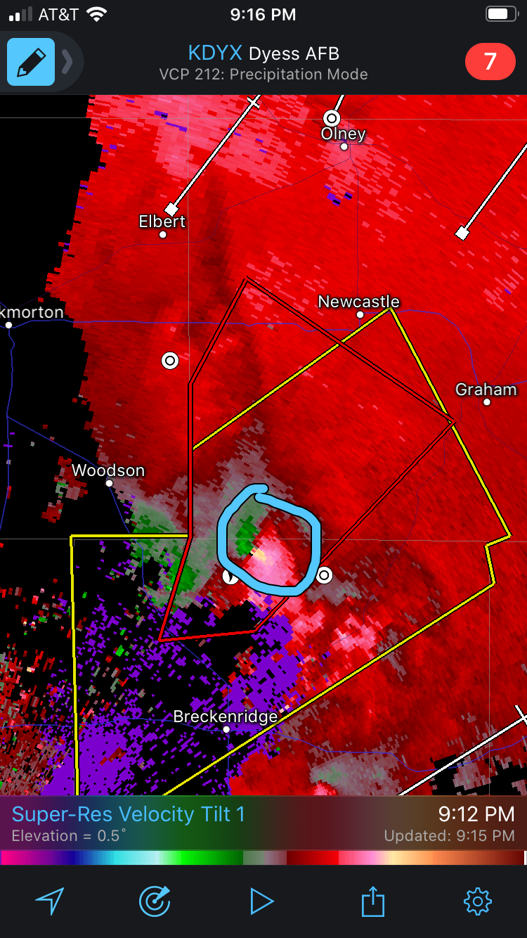
Graham is once again under a tornado warning, albeit at the northeastern-most edge of the warning polygon. It seems they had a tornado in the area with the previous round of storms, and this new warning only adds insult to injury. I'm worried that this supercell might try to take a similar path to the earlier storm that moved over Chico and Alvord. -
Severe Weather March 15-19
Sydney Claridge replied to Sydney Claridge's topic in Central/Western States
The storm north of Breckenridge is now beginning to enter areas previously impacted by tornado-warned supercells several hours ago. Areas like Graham, Bryson, and Jacksboro could be in the path once again if this storm stays on its present path. -
Severe Weather March 15-19
Sydney Claridge replied to Sydney Claridge's topic in Central/Western States
The area of rotation looks like it is going to go over Albany. This could be very bad. -
Severe Weather March 15-19
Sydney Claridge replied to Sydney Claridge's topic in Central/Western States
While this may seem like open country, the area of strong rotation either passed over or close to a major state prison facility (as I mentioned in a previous post). A well-built prison would probably be able to take a tornado hit well, but outbuildings would be a concern. -
Severe Weather March 15-19
Sydney Claridge replied to Sydney Claridge's topic in Central/Western States
I'm starting to get concerned about the track of the current tornado-warned storm. It will be getting pretty close to (or even go through part of) Abilene if it continues on its present track. EDIT: Abilene is now included in a Tornado Warning. Fortunately it says the tornado is radar-indicated (and not the strong wording seen back at Sterling City), although it is late at night and hard to spot as a result, so this warning still needs to be taken very seriously. EDIT 2: KTXS reports power flashes north of Tye. EDIT 3: Rotation moved near Impact/northernmost Abilene area. Hamby and the state prison facilities to the north (French Robertson and John Middleton Units) are now in the path of this possible tornado. Not a very populated area aside from the prisons. -
Severe Weather March 15-19
Sydney Claridge replied to Sydney Claridge's topic in Central/Western States
Looks like outflow ahead of this storm on the Palo Pinto/Parker county line may be helping keep it in check. Otherwise, the ingredients here would probably be good for more tornadoes.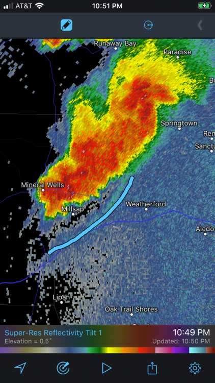
-
Severe Weather March 15-19
Sydney Claridge replied to Sydney Claridge's topic in Central/Western States
Unfortunately those storms west of Mineral Wells are outside of the anvil rain. I am very concerned about intensification as those storms approach the DFW area. Given current storm motions, those storms will impact the Metroplex unless they fall apart first. -
Severe Weather March 15-19
Sydney Claridge replied to Sydney Claridge's topic in Central/Western States
Confirmed tornado north of Breckenridge, near Crystal Falls. Watch that area to the south as well. The area of storms between Breckenridge and Cisco could be trying to develop rotation as well. A right-moving supercell forming there could be a concern for DFW down the line if it holds together.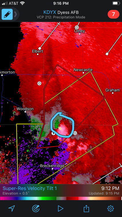
-
Severe Weather March 15-19
Sydney Claridge replied to Sydney Claridge's topic in Central/Western States
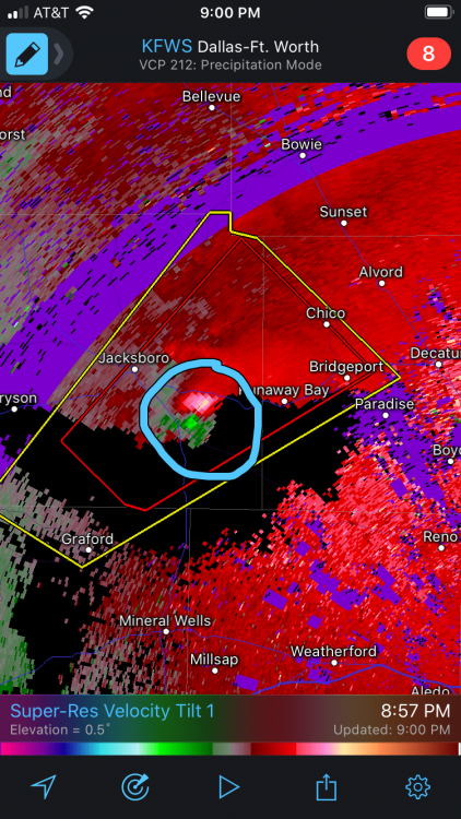
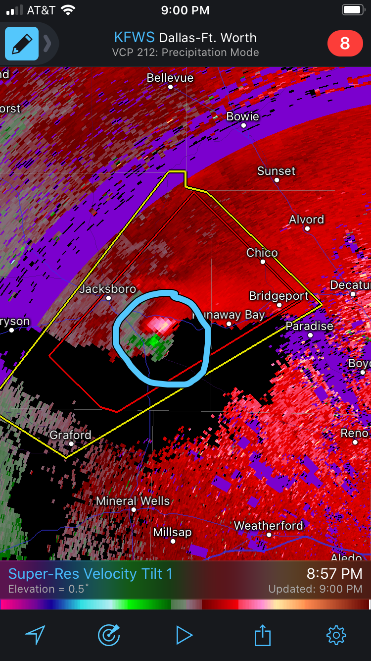
Strong rotation couplet moving east of Jacksboro, near Runaway Bay.