WxJordan
-
Posts
361 -
Joined
-
Last visited
Content Type
Profiles
Blogs
Forums
American Weather
Media Demo
Store
Gallery
Everything posted by WxJordan
-
2021-2022 Fall/Winter Mountains Thread
WxJordan replied to BlueRidgeFolklore's topic in Southeastern States
Mostly snow here, but probably about to mix with sleet. 6 inches and 24 and windy Morganton NC -
Winter Storm Izzy Obs Thread
WxJordan replied to Prismshine Productions's topic in Southeastern States
6 inches Morganton NC. 24 -
2021-2022 Fall/Winter Mountains Thread
WxJordan replied to BlueRidgeFolklore's topic in Southeastern States
Got some good size flakes here as well. 5 inches and 24 at 8:45 in Morganton. -
Winter Storm Izzy Obs Thread
WxJordan replied to Prismshine Productions's topic in Southeastern States
24 and around 5 in around 8:45 at Morganton -
2021-2022 Fall/Winter Mountains Thread
WxJordan replied to BlueRidgeFolklore's topic in Southeastern States
It's starting to snow heavier here in Morganton. Flakes have been small so far, so I am looking forward to the bigger flakes! Around an inch or so. -
Winter Storm Izzy Obs Thread
WxJordan replied to Prismshine Productions's topic in Southeastern States
Morganton, NC 30 degrees and a good dusting on the ground. Snowing moderately -
2021-2022 Fall/Winter Mountains Thread
WxJordan replied to BlueRidgeFolklore's topic in Southeastern States
When I was in school at Asheville (UNC-A) studying meteorology, it literally did not snow any in 2011 and 2012 winters LOL. I graduated in Dec 2013 and, if my memory serves correctly, it began snowing again. The weather in Asheville is crazy, so it can do anything in that valley LOL. @Met1985 @calculus1 @BretWx -
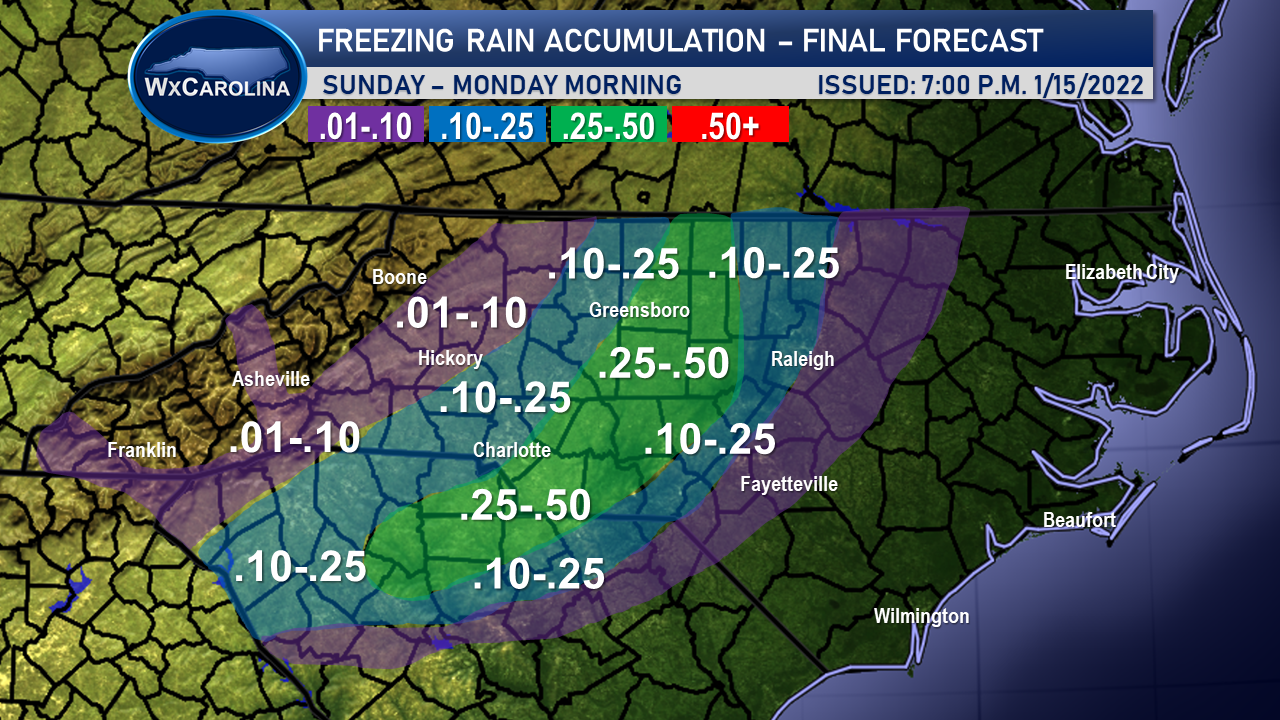
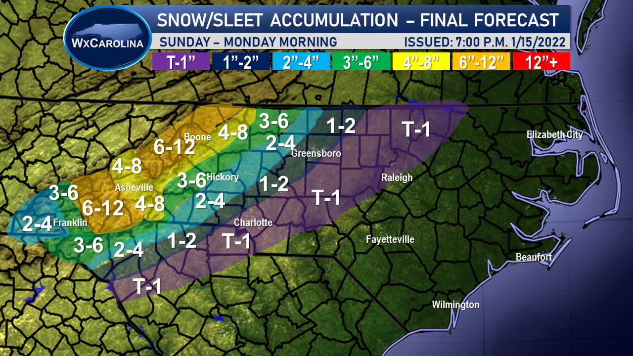
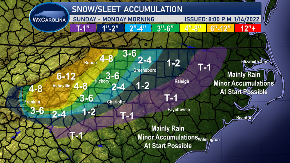
Final forecast maps attached. I cut down on the snow/sleet totals in the west due to the warm nose. The cut off line in western NC between a inches of snow/sleet and an inch of snow/sleet will be less than a few miles, and it is very very difficult to pin down.

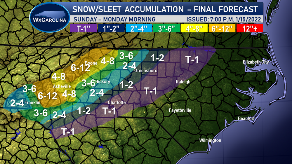
-
2021-2022 Fall/Winter Mountains Thread
WxJordan replied to BlueRidgeFolklore's topic in Southeastern States
40 in Morganton, NC. I cut down on my totals overall due to the warm nose for the final forecast. The gradient in western NC is going to be so sharp (2-4 inch difference over a couple of miles), it will be impossible to forecast). I really think it will occur somewhere around the Newton / Shelby / Statesville areas.

-
2021-2022 Fall/Winter Mountains Thread
WxJordan replied to BlueRidgeFolklore's topic in Southeastern States
Looking at the SkewTs on the NAM3km, it is so close once you get west of 321. Literally we are talking about a layer that is one degree or so above freezing. Always a difficult forecast, but usually that warm nose wins out. Still yet, I think most of the foothills gets a good 4-6 at least from the storm before it changes over late morning. -
2021-2022 Fall/Winter Mountains Thread
WxJordan replied to BlueRidgeFolklore's topic in Southeastern States
I have my penguin ready to go to measure the snow for me....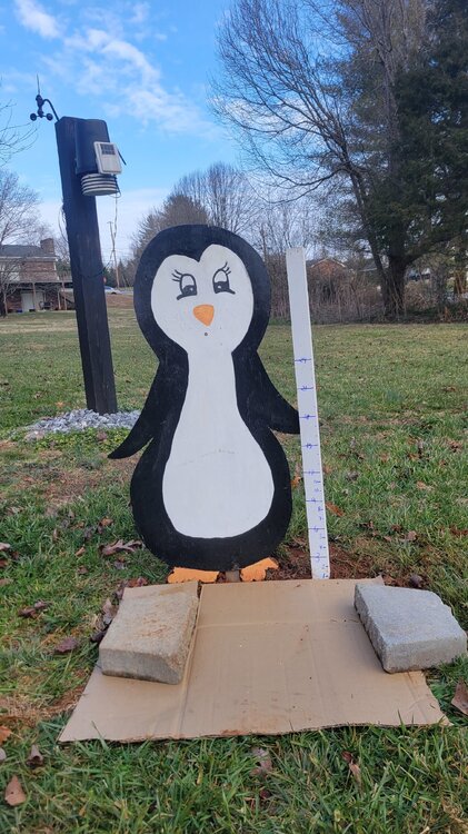
-
2021-2022 Fall/Winter Mountains Thread
WxJordan replied to BlueRidgeFolklore's topic in Southeastern States
I think NWS has a pretty good handle on it for our area. I really think the lower ends will probably verify. Usually once a changeover from snow to sleet occurs, it doesn't change back easily. The NAM is a higher resolution model, so throughout the day we need to monitor all the short range models closely for any trends. NAM usually is a little biased and too warm, in my experience. -
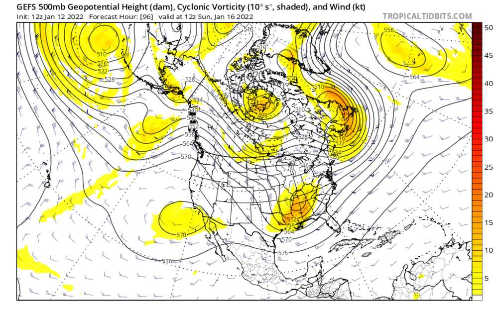
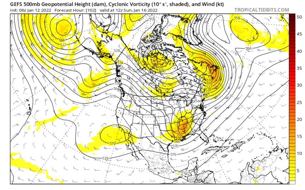
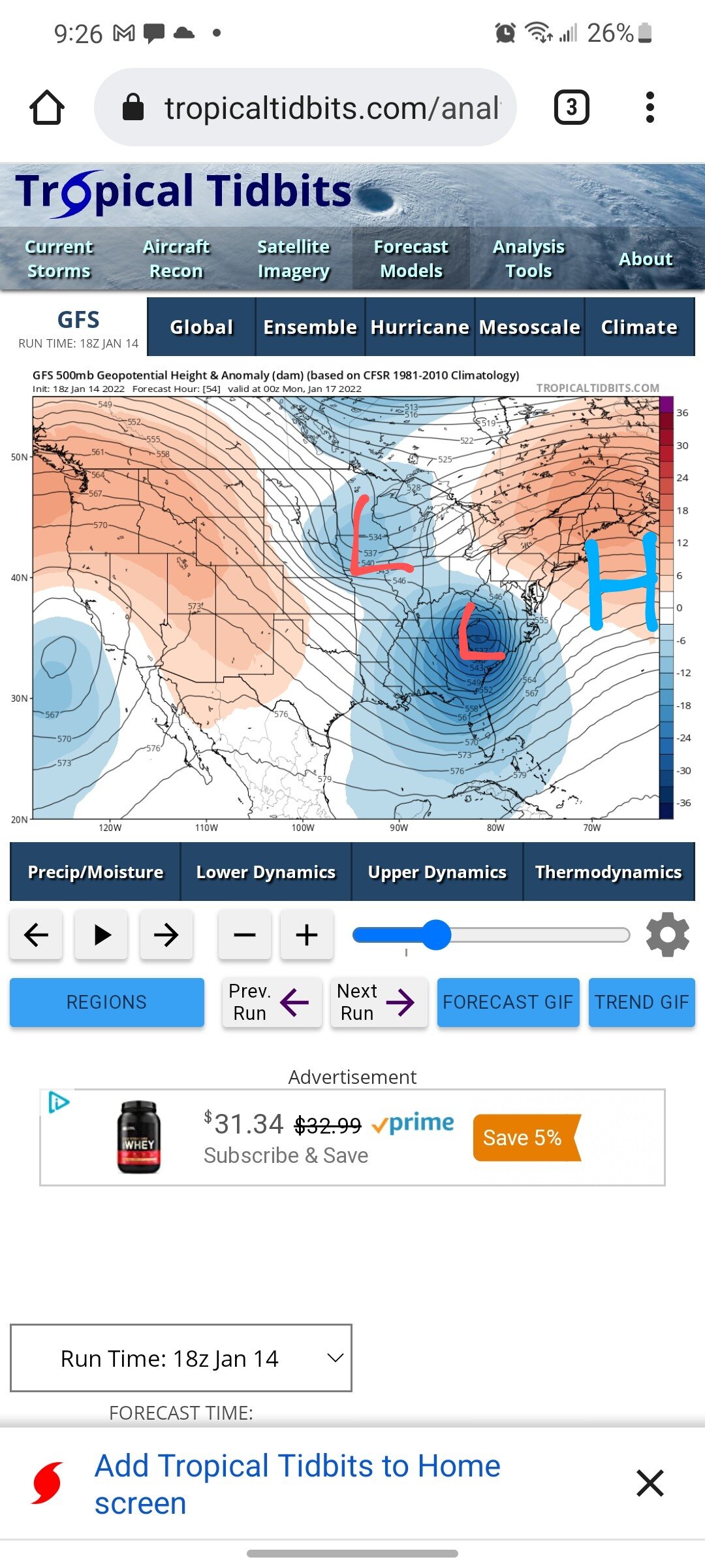
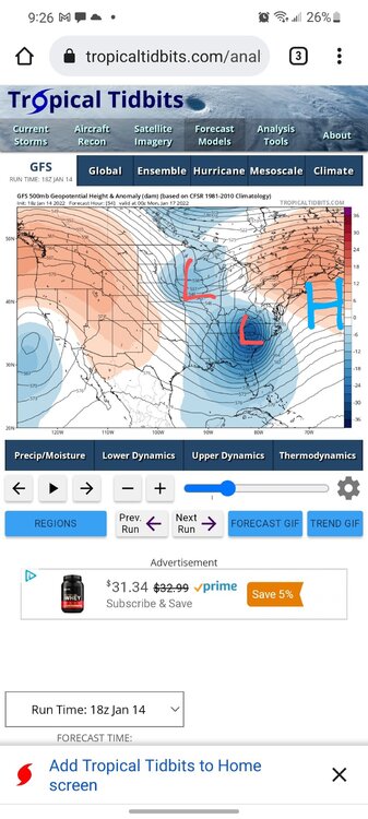
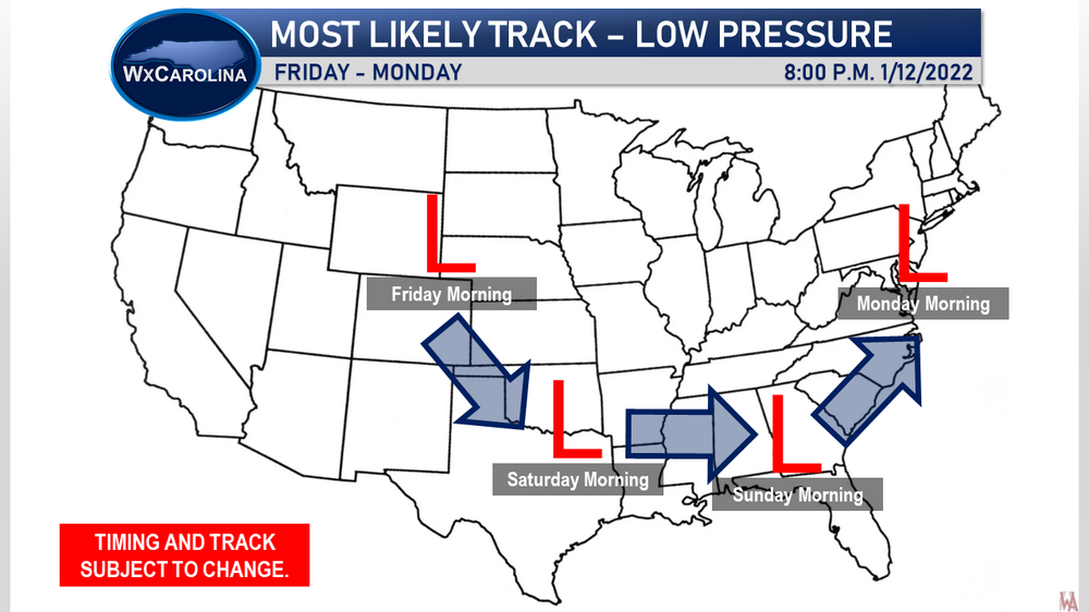
The SL strengthens quickly because the ULL is so strong and closed off. The ULL begins to interact with a shortwave shown on the 500 mb map and its pulls the ULL northward quickly. The ridge off the coast allows the ULL to escape, and we get an inland track. Definitely not a normal track.
-
It's been so nice to be back in the forum! My life kind of changed in 2020 with the birth of my first daughter. Being a dad is very important, so other things took a back seat. Then the pandemic hit with all its uncertainty. Then the supply shortages hit at work and we have been swamped. So, it's been nice to be back forecasting weather once again. I told my wife that I missed it so much, but the break probably helped me gather myself. I am hoping to become more active again.
-
I have the Vantage Pro2 and I love it. Overall has been very accurate and has lasted a very good while. I think I got it in 2014ish I belive.
-
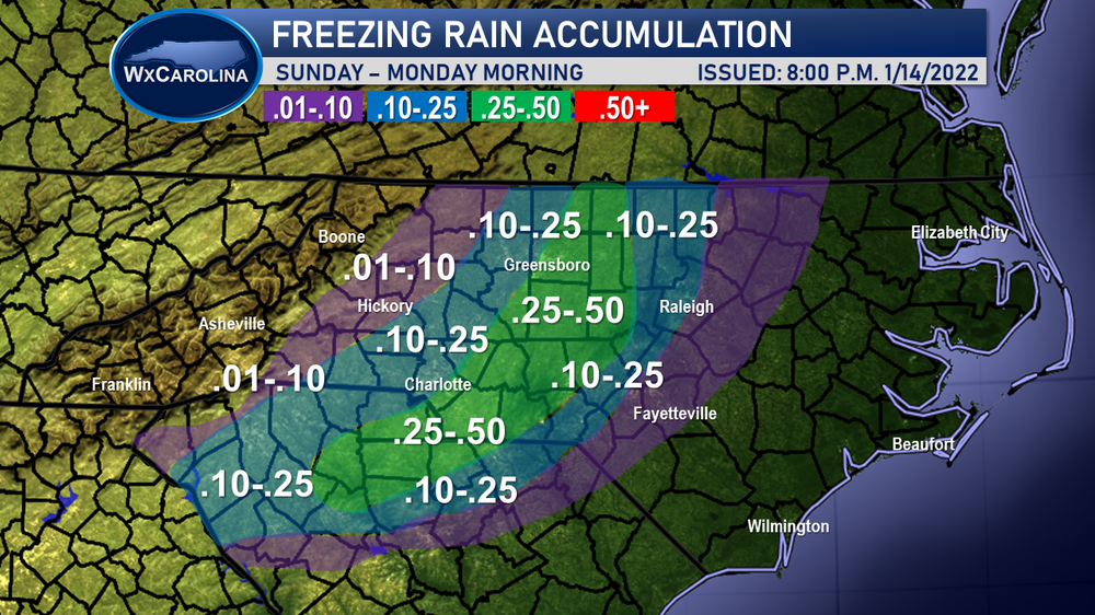
I have always said that sleet and freezing rain is such a waste of wintry weather....... Unfortunately that warm nose looks to be very very strong. Current forecast for all attached as well. Unfortunately I had a very very busy day today and was away from my computer. The really unique aspect for me is how strong the storm is getting without being off the coast. The storm goes from 1001 mb on the Gulf to 996 mb in southern GA to 995 mb in NC to 987 mb in VA without really ever moving over the Gulf Stream. Anyways, the wind is going to be something that will cause issues where the freezing rain area sets up. I think there will be numerous power outages in the freezing rain zone. Kind of just a messy messy storm if you will. Anyways, enjoy and I will be glad to answer any questions to the best of my ability. Video attached as well:
-
Here is the link to the video I posted on Facebook that I uploaded to YouTube as well. I kept it pretty simple, so I am not sure if it would interest anyone, but I figured I would post the link. https://www.youtube.com/watch?v=suJFqvY2W5A&t=145s
-
Thank you! The warm air is going to be an issue, no doubt. I really think the higher end forecast may need to come back down if the models hold this amount of sleet and freezing rain.
-
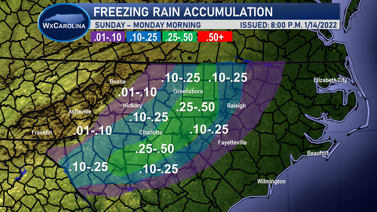
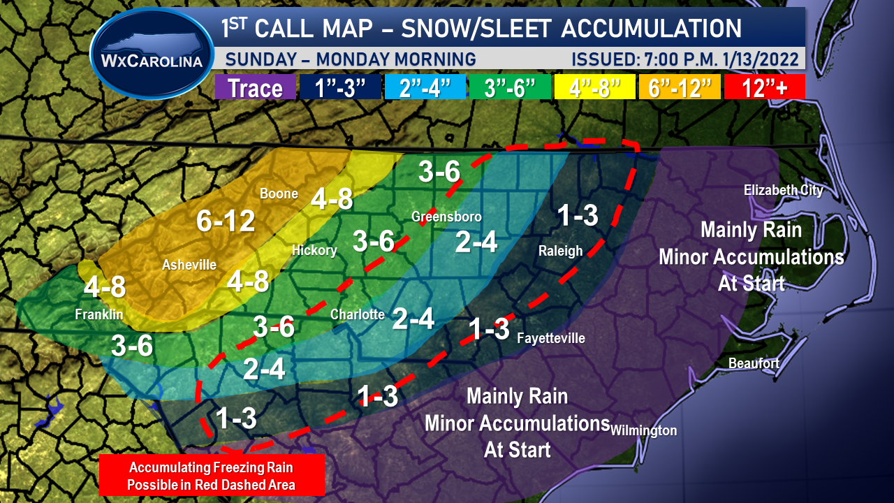
I just released my first snow/sleet accumulation map this evening. Pretty much in line with most other forecast. Wouldn't be shocked for 12+ inches in mountains. Maybe a little conservative in the foothills and western piedmont, but I really think this warm nose is going to be an issue. If the storm was a little further east, my forecast would change. But I do believe with a track this close to the coast, and with the storm strengthening, I believe we are going to have sleet issues everywhere outside the mountains. In central locations, I kept the freezing rain area kind of large. I personally do not think it will be quiet this large, so it will probably need to be scaled down as we get closer to the event. The warm air advection shown on the models is tough.

-
Tonight, mainly because of so much "misinformation" going on. Probably will go conservative being the first map and due to the uncertainty with the amount of sleet mixing in. Many local people here are saying 12+ is a guarantee.... Possible, but not the most likely scenario with the sleet mixing in. The weather apps....
-
NAM looks a little too warm aloft in my opinion, but sleet is going to be an issue, even north of 85 if the track hold. NAM track is very very similar to what I am thinking.
-
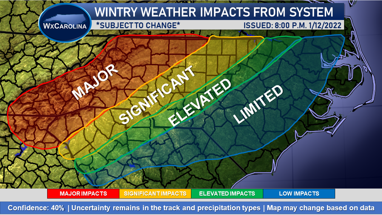
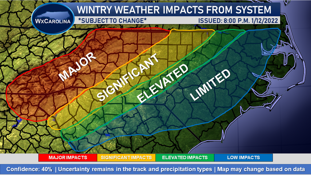
My thoughts on the overall system where we stand right now. Really, the models have remained relatively in agreement over the past few days with some changes in the track, ie. bringing closer to the coast. This really impacted the eastern Carolinas, but this is really setting up to be just a normal NC/SC winter storm with snow north of I-85 and all kinds of precip south of I-85. I really think that the RDU and Fayetteville areas are not totally out of the woods yet, and I wouldn't be shocked for the models to push the parent low a little further east. What really has me concerned is the warm nose in the western areas north of I-85. I think this is going to keep totals lower unless the low does push a little further west. So far it has been a fun system to track, and I look forward to seeing any trends in the 0z guidance!
-
Pretty good agreement with the models on the overall evolution. 12z EURO is a good hit for western NC, not so much for eastern NC, and the middle is going to be a mess with all kinds of wintry and non-wintry precipitation. It looks to be a typical winter storm with a nearly normal track on the way.
-
It's hard to get the system to go far enough south when it is moving so quickly and closing off so far west. I will admit, the current data model data has been relatively consistent. The warm nose is going to be a big issue IMO, even up into the foothills.
-
Hi everyone! It's been a while since I have been on the form, but we do finally have a chance of a winter storm, especially across western and central NC. Its been amazing how consistent overall the models, and especially the ensembles, have been over the past few days. While the system has definitely trended a further west than originally thought, it still appears most areas along and north of 85 stand a good chance of wintry weather from this system. The 06z GEFS and 12z GEFS are similar in the progression of the system, and that leads to increasing confidence in the forecast. Will be interesting to see what happens over the next 24-36 hours with the trends, but as of right now, 85 and north looks pretty good. RDU and points south are very big question marks without a track further south.